Trail Walking Suzette - Suzette-saint Amand-pas du loup - Photo

Suzette-saint Amand-pas du loup

© OpenStreetMap contributors
Length
Length
8.7 km
Max alt
Max alt
725 m
Uphill gradient
Uphill gradient
381 m
Km-Effort
Km-Effort  
13.8 km
Min alt
Min alt
385 m
Downhill gradient
Downhill gradient
381 m
Boucle
Boucle
Yes
Creation date :
2021-10-10 10:53:00.362
Updated on :
2021-10-13 09:34:14.417

(0 Reviews)

Walking
Walking
3h57
Difficulty : Medium

Scan this QR Code to open this trail in the SityTrail application

FREE GPS app for hiking

Logo SityTrail SityTrail

IGN / Geographical institutes

Download SityTrail from the App Store Download SityTrail from Google Play

Logo SityTrail SityTrail World

The world is yours!

Download SityTrail from the App Store Download SityTrail from Google Play Download SityTrail on Huawei AppGallery

About

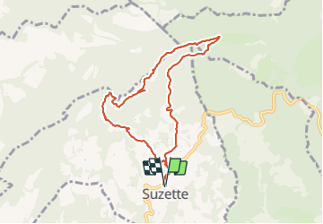
Trail Walking of 8.7 km to be discovered at Provence-Alpes-Côte d'Azur, Vaucluse, Suzette. This trail is proposed by Thierry0032.

Description

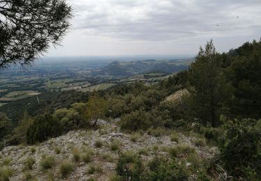
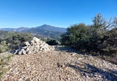
Montée jusqu'au point de vue du mont Saint Amand, on prend le chemin des crêtes (petit sentier sur la gauche après les antennes) jusqu'au pas su loup. Et un retour tranquille.
La promenade à été faite à faible allure.
Le chemin des crêtes peut être évité car il ne convient pas à tout le monde.

Elevation profile

Photos

24 photos in total. Please click on a photo to see them all in the gallery.

Positioning

Country:
France
Region :
Provence-Alpes-Côte d'Azur
Department/Province :
Vaucluse
Municipality :
Suzette
Location:
Unknown
Start:(UTM)
665395 ; 4892646 (31T) N.

Trails nearby

Trail Walking Séguret - 170917 EnCours - Photo
Walking
MarcheEtReve

Walking

Very easy
(1)
Séguret, Provence-Alpes-Côte d'Azur, Vaucluse, France
6.3 km | 9.8 km-effort
2h 8min
Yes
Trail Walking Lafare - Le tour du Grand Montmirail - Lafare - Photo
Walking
tracegps

Walking

Medium
(3)
Lafare, Provence-Alpes-Côte d'Azur, Vaucluse, France
9.1 km | 13.9 km-effort
2h 30min
Yes
Trail Walking Saint-Hippolyte-le-Graveyron - Le graveron petit circuit  - Photo
Walking
Vero7684

Walking

Easy
(1)
Saint-Hippolyte-le-Graveyron, Provence-Alpes-Côte d'Azur, Vaucluse, France
5.7 km | 8.8 km-effort
2h 5min
Yes
Trail Walking Lafare - Une approche des Dentelles de Montmirail - Photo
Walking
tracegps

Walking

Medium
(2)
Lafare, Provence-Alpes-Côte d'Azur, Vaucluse, France
6.6 km | 11.4 km-effort
3h 0min
Yes
Trail Walking Le Barroux - Lac du Barroux - Photo
Walking
alainbarrot

Walking

Very easy
(2)
Le Barroux, Provence-Alpes-Côte d'Azur, Vaucluse, France
5.8 km | 8 km-effort
1h 42min
Yes
Trail Running Le Barroux - Sortie Barroux - Photo
Running
ssi6159

Running

Very easy
(1)
Le Barroux, Provence-Alpes-Côte d'Azur, Vaucluse, France
12.9 km | 20 km-effort
1h 47min
Yes
Trail Walking Gigondas - les dentelles de Montmirail depuis Gigondas - Photo
Walking
alpha-pyxidis

Walking

Medium
(4)
Gigondas, Provence-Alpes-Côte d'Azur, Vaucluse, France
6.6 km | 11.3 km-effort
2h 26min
Yes
Trail Walking Sablet - 2024-01-12_13h24m19_sablet-prebayon-seguret-reco-validee - Photo
Walking
Maryma

Walking

Medium
(1)
Sablet, Provence-Alpes-Côte d'Azur, Vaucluse, France
19 km | 27 km-effort
6h 9min
Yes
Trail Walking La Roque-Alric - Les 4 sommets de la Roque Alric - Photo
Walking
supercolas

Walking

Medium
La Roque-Alric, Provence-Alpes-Côte d'Azur, Vaucluse, France
10.9 km | 18 km-effort
3h 32min
Yes


Close
My subscriptions