Trail Walking Meudon - Meudon- Chaville - Ville d'Avray - Photo

Meudon- Chaville - Ville d'Avray

 chessyca
chessyca

User

© OpenStreetMap contributors
Length
Length
28 km
Max alt
Max alt
188 m
Uphill gradient
Uphill gradient
544 m
Km-Effort
Km-Effort  
35 km
Min alt
Min alt
72 m
Downhill gradient
Downhill gradient
546 m
Boucle
Boucle
Yes
Creation date :
2022-01-23 07:37:35.039
Updated on :
2022-01-23 16:48:18.958

(0 Reviews)

Walking
Walking
6h03
Difficulty : Difficult

Scan this QR Code to open this trail in the SityTrail application

FREE GPS app for hiking

Logo SityTrail SityTrail

IGN / Geographical institutes

Download SityTrail from the App Store Download SityTrail from Google Play

Logo SityTrail SityTrail World

The world is yours!

Download SityTrail from the App Store Download SityTrail from Google Play Download SityTrail on Huawei AppGallery

About

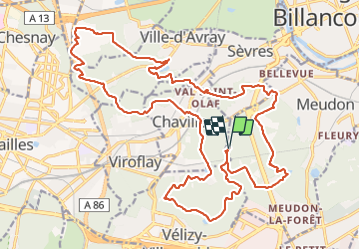
Trail Walking of 28 km to be discovered at Ile-de-France, Hauts-de-Seine, Meudon. This trail is proposed by chessyca.

Description

7 étangs , 500 mètres de dénivelés : une rando menée par Roland pour se remettre en forme

Elevation profile

Photos

Positioning

Country:
France
Region :
Ile-de-France
Department/Province :
Hauts-de-Seine
Municipality :
Meudon
Location:
Unknown
Start:(UTM)
441661 ; 5405815 (31U) N.

Trails nearby

Trail Walking Chaville - Le Sentier des 7 étangs - Photo
Walking
tracegps

Walking

Difficult
(5)
Chaville, Ile-de-France, Hauts-de-Seine, France
23 km | 31 km-effort
5h 0min
Yes
Trail Walking Verrières-le-Buisson - Sur les sentiers de découverte du Bois de Verrières - Photo
Walking
tracegps

Walking

Medium
(2)
Verrières-le-Buisson, Ile-de-France, Essonne, France
22 km | 27 km-effort
4h 40min
Yes
Trail Walking Viroflay - Les 3 Forêts; Meudon, Fausses Reposes et Versailles - Photo
Walking
tracegps

Walking

Difficult
(2)
Viroflay, Ile-de-France, Yvelines, France
25 km | 32 km-effort
5h 19min
Yes
Trail Walking Chaville - Sentier des deux Forêts - Meudon et Verrières - Photo
Walking
tracegps

Walking

Difficult
(2)
Chaville, Ile-de-France, Hauts-de-Seine, France
23 km | 29 km-effort
5h 0min
Yes
Trail Walking Boulogne-Billancourt - Parc de St Cloud et forêt de Fausses Reposes - Photo
Walking
tracegps

Walking

Medium
(1)
Boulogne-Billancourt, Ile-de-France, Hauts-de-Seine, France
18.2 km | 23 km-effort
4h 30min
No
Trail Walking Clamart - Tour des etangs - Bois de Clamart et de Meudon - Photo
Walking
GUIDE
affinetataille

Walking

Easy
Clamart, Ile-de-France, Hauts-de-Seine, France
8 km | 9.9 km-effort
2h 16min
Yes
Trail Cycle Chaville - chaville - maison lafitte - Photo
Cycle
Letizia

Cycle

Medium
(1)
Chaville, Ile-de-France, Hauts-de-Seine, France
44 km | 50 km-effort
3h 27min
No
Trail Mountain bike Chaville - grand circuit VTT - Photo
Mountain bike
macleon

Mountain bike

Very easy
(1)
Chaville, Ile-de-France, Hauts-de-Seine, France
32 km | 40 km-effort
Unknown
Yes
Trail Walking Ville-d'Avray - Etang Corot - Photo
Walking
mallovon

Walking

Easy
Ville-d'Avray, Ile-de-France, Hauts-de-Seine, France
3.8 km | 5 km-effort
1h 12min
Yes


Close
My subscriptions