Trail Walking Pourcieux - Crêtes du Mont Aurélien - Photo

Crêtes du Mont Aurélien

 ETMU5496
ETMU5496

User

© OpenStreetMap contributors
Length
Length
19.4 km
Max alt
Max alt
874 m
Uphill gradient
Uphill gradient
827 m
Km-Effort
Km-Effort  
30 km
Min alt
Min alt
367 m
Downhill gradient
Downhill gradient
829 m
Boucle
Boucle
Yes
Creation date :
2022-02-09 07:44:03.0
Updated on :
2023-03-09 16:47:11.956

(0 Reviews)

Walking
Walking
4h37
Difficulty : Difficult

Scan this QR Code to open this trail in the SityTrail application

FREE GPS app for hiking

Logo SityTrail SityTrail

IGN / Geographical institutes

Download SityTrail from the App Store Download SityTrail from Google Play

Logo SityTrail SityTrail World

The world is yours!

Download SityTrail from the App Store Download SityTrail from Google Play Download SityTrail on Huawei AppGallery

About

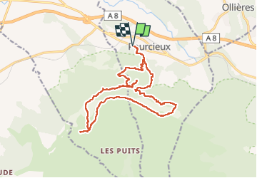
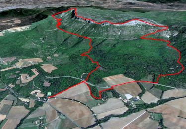
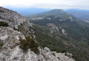
Trail Walking of 19.4 km to be discovered at Provence-Alpes-Côte d'Azur, Var, Pourcieux. This trail is proposed by ETMU5496.

Description

Départ aire de repos DN7 à proximité de Pourcieux.
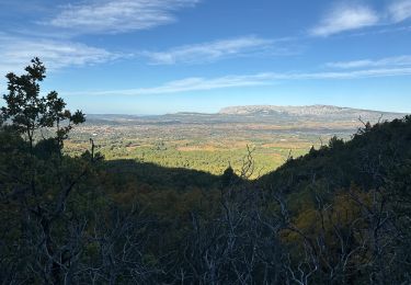
Suivre la large piste forestière qui monte jusqu’à une ruine juste à coté d’une ancienne carrière. Prendre le sentier caillouteux à droite qui grimpe jusqu’à rejoindre le chemin des contrebandiers. Quelques points orange-rouge peuvent aider à s’orienter. Juste avant d’atteindre la large piste, sur la gauche, on peut trouver l’épave d’un avion touristique. Bifurquer à gauche direction Est et suivre le chemin des contrebandiers sur un peu plus de 2 kms. Arrivé à une clairière plate » héliport du Mont Aurélien  » virer à droite direction Sud, une sente grimpe sèchement mais régulièrement jusqu’à une antenne puis le Pas des Ifs. Poursuivre le long de la crête par un petit sentier, passer le Pas de La croix ou se dressent des panneaux photovoltaïques brisés puis le Pas de Titet et remonter vers le rocher de l’Olympe à 872 m d’altitude. Suivre la sente qui redescend vers le Pas du Facteur. Faire un crochet (A/R) vers le rocher de onze heures puis redescendre pour retrouver le chemin des contrebandiers sur la gauche. Poursuivre la large piste sur environ 2 kms pour trouver juste à coté d’un sentier qui redescend vers Roquefeuille, une sente qui grimpe vers les ruines du Château de Saint-Barthélémy. Revenir sur la piste et poursuivre sur 1 km environ. Arrivé à une citerne, bifurquer sur la gauche direction Nord. Un petit sentier caillouteux grimpe régulièrement jusqu’à la Croix de Pourcieux et son magnifique panorama. Revenir sur la piste et prendre le chemin à droite. Puis rattraper la piste en contrebas et redescendre vers l'aire de repos, notre point de départ.

Elevation profile

Photos

Positioning

Country:
France
Region :
Provence-Alpes-Côte d'Azur
Department/Province :
Var
Municipality :
Pourcieux
Location:
Unknown
Start:(UTM)
724744 ; 4816691 (31T) N.

Trails nearby

Trail Walking Pourrières - JPS Monts  Aurélien-17655561 - Photo
Walking
GUIDE
affinetataille

Walking

Medium
(1)
Pourrières, Provence-Alpes-Côte d'Azur, Var, France
17.3 km | 27 km-effort
7h 0min
Yes
Trail Walking Pourcieux - 2022-11-11_17h53m46_pourcieux - Photo
Walking
Levant

Walking

Very difficult
(1)
Pourcieux, Provence-Alpes-Côte d'Azur, Var, France
18.2 km | 28 km-effort
6h 21min
Yes
Trail Walking Pourcieux - pas des iifs - Photo
Walking
coureurdegarrigue

Walking

Easy
(1)
Pourcieux, Provence-Alpes-Côte d'Azur, Var, France
15.8 km | 24 km-effort
5h 55min
Yes
Trail Walking Pourrières - Mt Olympe et le pas du Titet - Photo
Walking
ETMU5496

Walking

Difficult
Pourrières, Provence-Alpes-Côte d'Azur, Var, France
19.9 km | 32 km-effort
7h 15min
Yes
Trail Walking Pourcieux - 2024-03-02_17h01m33_La chouette d'Or Pourcieux - Photo
Walking

Walking

Medium
(1)
Pourcieux, Provence-Alpes-Côte d'Azur, Var, France
7.2 km | 11.9 km-effort
2h 41min
Yes
Trail Walking Trets - SityTrail - mont olympe + crête  - Photo
Walking
frizou83

Walking

Very difficult
(1)
Trets, Provence-Alpes-Côte d'Azur, Bouches-du-Rhône, France
13 km | 21 km-effort
4h 44min
Yes
Trail Walking Pourrières - Pourcieux :Mont Olympe et Pas du Titet - Photo
Walking
ETMU5496

Walking

Very difficult
(1)
Pourrières, Provence-Alpes-Côte d'Azur, Var, France
20 km | 32 km-effort
7h 22min
No
Trail Walking Pourcieux - Pourcieux - ¨Pas des Ifs, de la Croix et de Titet - Olympe - Rocher de Onze Heures - Croix de Pourcieux - Photo
Walking
LtZIP

Walking

Difficult
Pourcieux, Provence-Alpes-Côte d'Azur, Var, France
19.2 km | 30 km-effort
4h 49min
Yes
Trail Walking Pourcieux - Croix de pourcieux - Photo
Walking
gaggiroland

Walking

Difficult
Pourcieux, Provence-Alpes-Côte d'Azur, Var, France
9.9 km | 15 km-effort
3h 31min
Yes


Close
My subscriptions