
Wildenstein Pourri Faing Blockloch

bob68
User
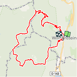

Length
11.7 km

Max alt
1108 m

Uphill gradient
563 m
Km-Effort
19.2 km

Min alt
567 m

Downhill gradient
564 m
Boucle
Yes
Creation date :
2014-12-10 00:00:00.0
Updated on :
2014-12-10 00:00:00.0
3h21
Difficulty : Medium

FREE GPS app for hiking
 SityTrail
IGN / Geographical institutes
SityTrail Plus
The world is yours!
About
Trail Walking of 11.7 km to be discovered at Grand Est, Haut-Rhin, Wildenstein. This trail is proposed by bob68.
Photos


Positioning
Country:
France
Region :
Grand Est
Department/Province :
Haut-Rhin
Municipality :
Wildenstein
Location:
Unknown
Start:(Dec)
Start:(UTM)
347824 ; 5315745 (32T) N.
Comments