Trail On foot Val de Louyre et Caudeau - Boucle du Maquis - Photo

Tous les sentiers balisés d’Europe PRO

© OpenStreetMap contributors
Length
Length
4.9 km
Max alt
Max alt
254 m
Uphill gradient
Uphill gradient
111 m
Km-Effort
Km-Effort  
6.4 km
Min alt
Min alt
177 m
Downhill gradient
Downhill gradient
110 m
Boucle
Boucle
Yes
Signpost
Signpost
Creation date :
2022-02-15 17:53:20.496
Updated on :
2022-03-02 20:01:40.908

(0 Reviews)

On foot
On foot
1h27
Difficulty : Easy

Scan this QR Code to open this trail in the SityTrail application

FREE GPS app for hiking

Logo SityTrail SityTrail

IGN / Geographical institutes

Download SityTrail from the App Store Download SityTrail from Google Play

Logo SityTrail SityTrail World

The world is yours!

Download SityTrail from the App Store Download SityTrail from Google Play Download SityTrail on Huawei AppGallery

About

Trail On foot of 4.9 km to be discovered at New Aquitaine, Dordogne, Val de Louyre et Caudeau. This trail is proposed by SityTrail - itinéraires balisés pédestres.

Positioning

Country:
France
Region :
New Aquitaine
Department/Province :
Dordogne
Municipality :
Val de Louyre et Caudeau
Location:
Cendrieux
Start:(UTM)
330256 ; 4981264 (31T) N.

Trails nearby

Trail Walking Val de Louyre et Caudeau - Boucle de Cendrieux - Photo
Walking
CC.RIDER

Walking

Difficult
Val de Louyre et Caudeau, New Aquitaine, Dordogne, France
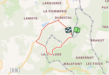
13.3 km | 16.6 km-effort
3h 45min
Yes
Trail Walking Val de Louyre et Caudeau - boucle boissiere - Photo
Walking
fab0202

Walking

Easy
Val de Louyre et Caudeau, New Aquitaine, Dordogne, France
13.1 km | 16.5 km-effort
2h 38min
Yes
Trail Walking Val de Louyre et Caudeau - Les Truffières st Avére  - Photo
Walking
Isabelle Nadaud

Walking

Medium
Val de Louyre et Caudeau, New Aquitaine, Dordogne, France
8.4 km | 11 km-effort
3h 20min
Yes
Trail Walking Val de Louyre et Caudeau - boucle des truffiers - Photo
Walking
fab0202

Walking

Easy
Val de Louyre et Caudeau, New Aquitaine, Dordogne, France
10.9 km | 14.2 km-effort
2h 12min
No
Trail Walking Paunat - Paunat 12,5km - Photo
Walking
amelie14

Walking

Easy
Paunat, New Aquitaine, Dordogne, France
12.8 km | 16.4 km-effort
2h 45min
Yes
Trail Walking Journiac - boucle journiac - Photo
Walking
fab0202

Walking

Very easy
Journiac, New Aquitaine, Dordogne, France
12.2 km | 15.6 km-effort
3h 3min
Yes
Trail Walking Saint-Avit-de-Vialard - Boucle de Saint Avit de Vialard - Photo
Walking
lacostej

Walking

Medium
(1)
Saint-Avit-de-Vialard, New Aquitaine, Dordogne, France
21 km | 29 km-effort
4h 5min
Yes
Trail Walking Mauzens-et-Miremont - Mauzens et Miremont  - Photo
Walking
houbart

Walking

Difficult
(1)
Mauzens-et-Miremont, New Aquitaine, Dordogne, France
10.1 km | 13 km-effort
2h 57min
Yes
Trail Running Val de Louyre et Caudeau - Ste Alvère - Photo
Running
amelie14

Running

Medium
Val de Louyre et Caudeau, New Aquitaine, Dordogne, France
9.3 km | 12.4 km-effort
56min
Yes


Close
My subscriptions