Trail Walking Montauriol - 20220220 Boucle Montauriol - Photo

20220220 Boucle Montauriol

 ThonyM
ThonyM

User

© OpenStreetMap contributors
Length
Length
15.8 km
Max alt
Max alt
405 m
Uphill gradient
Uphill gradient
445 m
Km-Effort
Km-Effort  
22 km
Min alt
Min alt
197 m
Downhill gradient
Downhill gradient
445 m
Boucle
Boucle
Yes
Creation date :
2022-02-20 08:00:32.0
Updated on :
2022-02-20 12:45:57.619

(0 Reviews)

Walking
Walking
3h42
Difficulty : Medium

Scan this QR Code to open this trail in the SityTrail application

FREE GPS app for hiking

Logo SityTrail SityTrail

IGN / Geographical institutes

Download SityTrail from the App Store Download SityTrail from Google Play

Logo SityTrail SityTrail World

The world is yours!

Download SityTrail from the App Store Download SityTrail from Google Play Download SityTrail on Huawei AppGallery

About

Trail Walking of 15.8 km to be discovered at Occitania, Pyrénées-Orientales, Montauriol. This trail is proposed by ThonyM.

Description

Pour une bonne promenade dominicale. Certains passages à re-évaluer à cause des pistes retracées (coupe-feux.

Elevation profile

Photos

Positioning

Country:
France
Region :
Occitania
Department/Province :
Pyrénées-Orientales
Municipality :
Montauriol
Location:
Unknown
Start:(UTM)
477365 ; 4713743 (31T) N.

Trails nearby

Trail Walking Tordères - 66 TORDÈRES - LLAURO, promenade en forêt méditerranéenne, cistes, genêts, bruyères. Arbousiers, chênes Lièges, chênes verts, pins - Photo
Walking
jeff66

Walking

Difficult
(1)
Tordères, Occitania, Pyrénées-Orientales, France
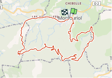
11.9 km | 17.5 km-effort
2h 23min
Yes
Trail Walking Llupia - 66 LLUPIA - FOURQUES - TERRATS promenade dans les ASPRES et son vignoble  - Photo
Walking
jeff66

Walking

Medium
(1)
Llupia, Occitania, Pyrénées-Orientales, France
15 km | 18.2 km-effort
2h 36min
Yes
Trail Walking Fourques - Fourques  - Photo
Walking
Fildesir

Walking

Very easy
(1)
Fourques, Occitania, Pyrénées-Orientales, France
14.2 km | 16.4 km-effort
5h 17min
Yes
Trail Walking Castelnou - Thuir  - Photo
Walking
Jean-François BALANGER

Walking

Very easy
(1)
Castelnou, Occitania, Pyrénées-Orientales, France
9.3 km | 12.1 km-effort
4h 4min
No
Trail Walking Llauro - Col de Llauro- Roc del Quers - Photo
Walking
perittel

Walking

Easy
(1)
Llauro, Occitania, Pyrénées-Orientales, France
8.9 km | 12.9 km-effort
3h 11min
Yes
Trail Walking Montauriol - Montauriol : les points de vue. - Photo
Walking
prehault

Walking

Easy
(4)
Montauriol, Occitania, Pyrénées-Orientales, France
4 km | 5.3 km-effort
1h 8min
Yes
Trail Walking Fourques - fourques sentier des histoires  - Photo
Walking
66Gribouille83

Walking

Medium
Fourques, Occitania, Pyrénées-Orientales, France
9.1 km | 10.9 km-effort
2h 47min
Yes
Trail Walking Fourques - fourques - Photo
Walking
66Gribouille83

Walking

Medium
Fourques, Occitania, Pyrénées-Orientales, France
7.9 km | 9.3 km-effort
3h 13min
Yes
Trail Walking Sainte-Colombe-de-la-Commanderie - 20230316 Sté Colombe-Castelnou - Photo
Walking
ThonyM

Walking

Medium
Sainte-Colombe-de-la-Commanderie, Occitania, Pyrénées-Orientales, France
16.3 km | 23 km-effort
3h 55min
Yes


Close
My subscriptions