Trail Walking Artigue - 2022-02-26 Artigue - cabane de peyrehitte - mont Majou -  luchonais - Photo

2022-02-26 Artigue - cabane de peyrehitte - mont Majou - luchonais

 jacq58
jacq58

User

© OpenStreetMap contributors
Length
Length
12 km
Max alt
Max alt
1943 m
Uphill gradient
Uphill gradient
730 m
Km-Effort
Km-Effort  
22 km
Min alt
Min alt
1214 m
Downhill gradient
Downhill gradient
733 m
Boucle
Boucle
Yes
Creation date :
2022-02-26 09:09:28.222
Updated on :
2022-02-28 19:39:04.962

(0 Reviews)

Walking
Walking
3h33
Difficulty : Difficult

Scan this QR Code to open this trail in the SityTrail application

FREE GPS app for hiking

Logo SityTrail SityTrail

IGN / Geographical institutes

Download SityTrail from the App Store Download SityTrail from Google Play

Logo SityTrail SityTrail World

The world is yours!

Download SityTrail from the App Store Download SityTrail from Google Play Download SityTrail on Huawei AppGallery

About

Trail Walking of 12 km to be discovered at Occitania, Haute-Garonne, Artigue. This trail is proposed by jacq58.

Description

départ du parking juste à l'entrée de Artigue, aller jusqu'à l'église et prendre le chemin qui monte légèrement à droite et suivre le balisage blanc et rouge du GR10.

Elevation profile

Photos

Positioning

Country:
France
Region :
Occitania
Department/Province :
Haute-Garonne
Municipality :
Artigue
Location:
Unknown
Start:(UTM)
305409 ; 4744678 (31T) N.

Trails nearby

Trail Snowshoes Juzet-de-Luchon - JUZET - PAS DE LA COMBE (LABACH) - Photo
Snowshoes
Marcocroco

Snowshoes

Medium
(1)
Juzet-de-Luchon, Occitania, Haute-Garonne, France
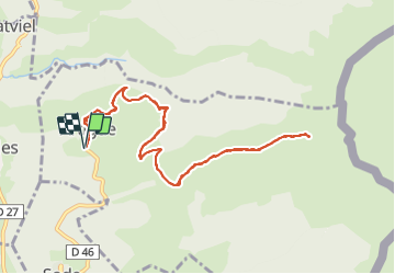
7.1 km | 12.5 km-effort
2h 33min
Yes
Trail Walking Saccourvielle - Cap de Salières en boucle depuis Saccourvielle - Photo
Walking
GUIDE
lhomme.ph

Walking

Medium
Saccourvielle, Occitania, Haute-Garonne, France
12.1 km | 24 km-effort
6h 23min
Yes
Trail Walking Baren - mail de la Pique 01 2018 - Photo
Walking
chrisgps

Walking

Very easy
(1)
Baren, Occitania, Haute-Garonne, France
7.6 km | 19.1 km-effort
4h 55min
Yes
Trail Walking Bagnères-de-Luchon - GR 10 - 3 - Photo
Walking
loic09

Walking

Medium
(2)
Bagnères-de-Luchon, Occitania, Haute-Garonne, France
250 km | 489 km-effort
89h 8min
No
Trail Walking Artigue - ARTIGUE - Gouaux de Luchon - chemin forestier - Photo
Walking
josy31

Walking

Medium
(1)
Artigue, Occitania, Haute-Garonne, France
13.7 km | 23 km-effort
3h 21min
Yes
Trail Walking Artigue - Artigue par la cabane du plan Bosc et la cabane de Saunères - Photo
Walking
swp648

Walking

Difficult
Artigue, Occitania, Haute-Garonne, France
10.5 km | 18.3 km-effort
4h 10min
Yes
Trail Walking Baren - Mail de la Pique depuis Baren - Photo
Walking
GUIDE
lhomme.ph

Walking

Difficult
Baren, Occitania, Haute-Garonne, France
9.8 km | 23 km-effort
6h 43min
Yes
Trail On foot Artigue - Pic de Bacanère - Photo
On foot
PRO

On foot

Easy
Artigue, Occitania, Haute-Garonne, France
8.3 km | 18.3 km-effort
4h 9min
No
Trail Walking Artigue - Le Montmajou en boucle depuis Artigue - Photo
Walking
GUIDE
lhomme.ph

Walking

Medium
Artigue, Occitania, Haute-Garonne, France
11.1 km | 23 km-effort
6h 7min
Yes


Close
My subscriptions