Trail Walking Monein - LE SENTIER DU LARING - Photo
© OpenStreetMap contributors
Length
Length
12.4 km
Max alt
Max alt
349 m
Uphill gradient
Uphill gradient
340 m
Km-Effort
Km-Effort  
16.9 km
Min alt
Min alt
196 m
Downhill gradient
Downhill gradient
338 m
Boucle
Boucle
Yes
Creation date :
2022-03-07 07:57:26.397
Updated on :
2022-03-08 16:52:25.434

(0 Reviews)

Walking
Walking
3h15
Difficulty : Difficult

Scan this QR Code to open this trail in the SityTrail application

FREE GPS app for hiking

Logo SityTrail SityTrail

IGN / Geographical institutes

Download SityTrail from the App Store Download SityTrail from Google Play

Logo SityTrail SityTrail World

The world is yours!

Download SityTrail from the App Store Download SityTrail from Google Play Download SityTrail on Huawei AppGallery

About

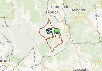
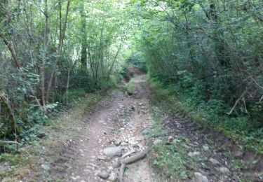
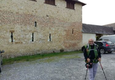
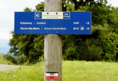
Trail Walking of 12.4 km to be discovered at New Aquitaine, Pyrénées-Atlantiques, Monein. This trail is proposed by marche64110.

Description

ATTENDRE LES BEAUX  JOURS

Elevation profile

Positioning

Country:
France
Region :
New Aquitaine
Department/Province :
Pyrénées-Atlantiques
Municipality :
Monein
Location:
Unknown
Start:(UTM)
701824 ; 4791640 (30T) N.

Trails nearby

Trail Nordic walking Estialescq - GR 653 D  Barat / Lacombe  Lacommande Haut d'Estialecq fait  2020 - Photo
Nordic walking
GUIDE
marmotte65

Nordic walking

Easy
(1)
Estialescq, New Aquitaine, Pyrénées-Atlantiques, France
8.7 km | 11.8 km-effort
4h 9min
No
Trail Walking Aubertin - AUBERTIN (PPT) de la hélère à la baïse  fait (G3)  2641287 - Photo
Walking
GUIDE
marmotte65

Walking

Easy
Aubertin, New Aquitaine, Pyrénées-Atlantiques, France
12 km | 17.1 km-effort
3h 13min
Yes
Trail Walking Lacommande - LACOMMANDE/HAUT D'ESTIALECQ balisage GR 653D - Photo
Walking
GUIDE
marmotte65

Walking

Difficult
Lacommande, New Aquitaine, Pyrénées-Atlantiques, France
10.2 km | 14.8 km-effort
2h 58min
No
Trail Walking Saint-Faust - Coteaux de St Faust de Bas - Photo
Walking
tracegps

Walking

Easy
(2)
Saint-Faust, New Aquitaine, Pyrénées-Atlantiques, France
7.6 km | 9.9 km-effort
2h 0min
Yes
Trail Walking Lacommande - La voie d'Arles de Lacommande à Oloron - Photo
Walking
tracegps

Walking

Difficult
Lacommande, New Aquitaine, Pyrénées-Atlantiques, France
15.2 km | 22 km-effort
3h 0min
No
Trail Mountain bike Saint-Faust - ch pau - Photo
Mountain bike
pascal.davancens

Mountain bike

Very easy
Saint-Faust, New Aquitaine, Pyrénées-Atlantiques, France
16.6 km | 18.6 km-effort
29min
No
Trail Walking Lasseube - croix de daguet - Photo
Walking
gnedellec

Walking

Medium
Lasseube, New Aquitaine, Pyrénées-Atlantiques, France
51 km | 82 km-effort
8h 39min
No
Trail sport Précilhon - Gites - Photo
sport
licasino

sport

Very easy
Précilhon, New Aquitaine, Pyrénées-Atlantiques, France
4.8 km | 6.8 km-effort
Unknown
Yes
Trail Walking Lacommande - Trace G3 Lacommande Guy - Photo
Walking
mitch1952

Walking

Lacommande, New Aquitaine, Pyrénées-Atlantiques, France
13.4 km | 18.2 km-effort
5h 12min
Yes


Close
My subscriptions