Trail Walking Alos - Le chemin de la Quère - Alos  - Photo

Le chemin de la Quère - Alos

 tracegps
tracegps

User

© OpenStreetMap contributors
Length
Length
11.5 km
Max alt
Max alt
1133 m
Uphill gradient
Uphill gradient
683 m
Km-Effort
Km-Effort  
21 km
Min alt
Min alt
658 m
Downhill gradient
Downhill gradient
689 m
Boucle
Boucle
Yes
Creation date :
2014-12-10 00:00:00.0
Updated on :
2014-12-10 00:00:00.0

(1 Reviews)

Walking
Walking
4h00
Difficulty : Difficult

Scan this QR Code to open this trail in the SityTrail application

FREE GPS app for hiking

Logo SityTrail SityTrail

IGN / Geographical institutes

Download SityTrail from the App Store Download SityTrail from Google Play

Logo SityTrail SityTrail World

The world is yours!

Download SityTrail from the App Store Download SityTrail from Google Play Download SityTrail on Huawei AppGallery

About

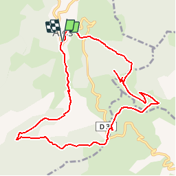
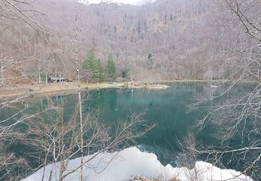
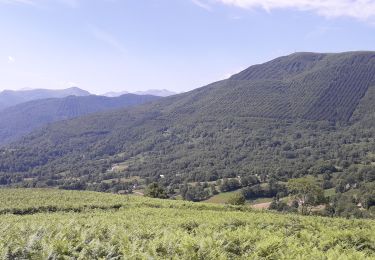
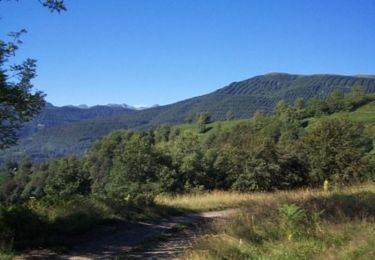
Trail Walking of 11.5 km to be discovered at Occitania, Ariège, Alos. This trail is proposed by tracegps.

Description

Départ au parking aménagé du cimetière d'Alos (Sud d'Alos, sur la D 37). Le circuit parcourt de magnifiques hêtraies et soulanes. Il offre des vues imprenables sur les Pyrénées. Du Pic de la Quère, on peut admirer le dôme du Cap de Bouirex. Le circuit est extrait de "Quelques idées de balades - Sur les chemins de piémont autour de St-Girons" sur le site de l'Office de Tourisme de St-Girons St Lizier.

Elevation profile

Photos

Positioning

Country:
France
Region :
Occitania
Department/Province :
Ariège
Municipality :
Alos
Location:
Unknown
Start:(UTM)
348489 ; 4751990 (31T) N.

Comments

Please log in to post a review or rate the element


Trails nearby

Trail Walking Bethmale - Bethmale - Photo
Walking
Gepeto_22

Walking

Medium
(2)
Bethmale, Occitania, Ariège, France
5.4 km | 8.8 km-effort
2h 20min
Yes
Trail Walking Bethmale - refuge Salvador - Photo
Walking
chrisgps

Walking

Very difficult
Bethmale, Occitania, Ariège, France
16 km | 25 km-effort
5h 46min
Yes
Trail Electric bike Soueix-Rogalle - st girons rogalle 21/06 - Photo
Electric bike
ra2000

Electric bike

Difficult
Soueix-Rogalle, Occitania, Ariège, France
27 km | 42 km-effort
5h 33min
No
Trail Walking Alos - Le Relais du Bouirex - Photo
Walking
tracegps

Walking

Medium
Alos, Occitania, Ariège, France
9.4 km | 17.5 km-effort
4h 30min
Yes
Trail Mountain bike Seix - Les bords du Salat à partir de Seix - Photo
Mountain bike
tracegps

Mountain bike

Medium
Seix, Occitania, Ariège, France
6.8 km | 12.5 km-effort
1h 30min
Yes
Trail Walking Seix - Les bords du Salat à partir de Seix - Photo
Walking
tracegps

Walking

Medium
Seix, Occitania, Ariège, France
6.8 km | 12.5 km-effort
2h 40min
Yes
Trail Walking Seix - La Paloumère par les crêtes - Photo
Walking
tracegps

Walking

Medium
Seix, Occitania, Ariège, France
5.4 km | 8.6 km-effort
2h 0min
Yes
Trail Equestrian Seix - La Paloumère - Photo
Equestrian
tracegps

Equestrian

Medium
Seix, Occitania, Ariège, France
3.8 km | 6 km-effort
1h 0min
Yes
Trail Walking Seix - La Paloumère - Photo
Walking
tracegps

Walking

Medium
Seix, Occitania, Ariège, France
3.8 km | 6 km-effort
1h 19min
Yes


Close
My subscriptions