Trail Walking Gentioux-Pigerolles - Circuit au Nord Est de Gentioux-Pigerolles - Photo

Circuit au Nord Est de Gentioux-Pigerolles

 tracegps
tracegps

User

© OpenStreetMap contributors
Length
Length
17 km
Max alt
Max alt
855 m
Uphill gradient
Uphill gradient
373 m
Km-Effort
Km-Effort  
22 km
Min alt
Min alt
711 m
Downhill gradient
Downhill gradient
366 m
Boucle
Boucle
Yes
Creation date :
2014-12-10 00:00:00.0
Updated on :
2014-12-10 00:00:00.0

(0 Reviews)

Walking
Walking
6h00
Difficulty : Medium

Scan this QR Code to open this trail in the SityTrail application

FREE GPS app for hiking

Logo SityTrail SityTrail

IGN / Geographical institutes

Download SityTrail from the App Store Download SityTrail from Google Play

Logo SityTrail SityTrail World

The world is yours!

Download SityTrail from the App Store Download SityTrail from Google Play Download SityTrail on Huawei AppGallery

About

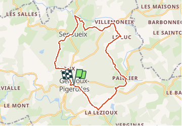
Trail Walking of 17 km to be discovered at New Aquitaine, Creuse, Gentioux-Pigerolles. This trail is proposed by tracegps.

Description

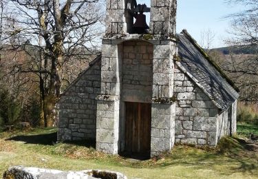
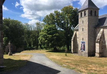
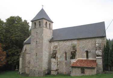
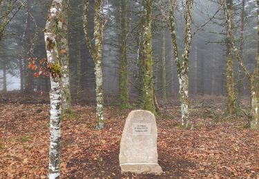
Partant du célèbre Monument aux Morts de Gentioux, le circuit se dirige vers le nord, à travers la forêt pour rejoindre le village de Senoueix et son pont atypique. On rejoint les hameaux de Villemoneix, le Luc puis Paillier avec son église templière. La boucle se termine par le passage via Lalézioux avant de revenir sur Gentioux. Circuit sans grande difficulté et avec un faible dénivelé pour la région.

Elevation profile

Photos

Positioning

Country:
France
Region :
New Aquitaine
Department/Province :
Creuse
Municipality :
Gentioux-Pigerolles
Location:
Unknown
Start:(UTM)
421920 ; 5070608 (31T) N.

Trails nearby

Trail Walking Peyrelevade - Fred Chappelle du Rat - Photo
Walking
arnoultjf

Walking

Easy
Peyrelevade, New Aquitaine, Corrèze, France
3 km | 4.2 km-effort
47min
Yes
Trail Walking Gentioux-Pigerolles - Gentilhomme pigerolles  - Photo
Walking
Alainschost

Walking

Gentioux-Pigerolles, New Aquitaine, Creuse, France
12.8 km | 17.2 km-effort
4h 1min
Yes
Trail Walking Faux-la-Montagne - faux et le lac - Photo
Walking
viam19

Walking

Medium
Faux-la-Montagne, New Aquitaine, Creuse, France
15.2 km | 19 km-effort
4h 6min
Yes
Trail Mountain bike Gentioux-Pigerolles - Circuit au Nord Est de Gentioux-Pigerolles - Photo
Mountain bike
tracegps

Mountain bike

Medium
Gentioux-Pigerolles, New Aquitaine, Creuse, France
17 km | 22 km-effort
2h 0min
Yes
Trail Walking Faux-la-Montagne - Faux la montagne - Le Chammet  - Photo
Walking
Gegetop

Walking

Medium
Faux-la-Montagne, New Aquitaine, Creuse, France
15.8 km | 19.6 km-effort
4h 8min
Yes
Trail Walking La Nouaille - la boucle du Puy Riau - Photo
Walking
marcagif

Walking

Easy
La Nouaille, New Aquitaine, Creuse, France
5.1 km | 6.7 km-effort
1h 20min
Yes
Trail Walking Faux-la-Montagne - tour du lac de Faux - Photo
Walking
martinjacque

Walking

Very easy
Faux-la-Montagne, New Aquitaine, Creuse, France
4.1 km | 4.8 km-effort
1h 27min
Yes
Trail Walking Faux-la-Montagne - Faux-la-Montagne lac de Faux 8km - Photo
Walking
YV24

Walking

Easy
Faux-la-Montagne, New Aquitaine, Creuse, France
7.7 km | 9.2 km-effort
2h 11min
Yes
Trail Walking Faux-la-Montagne - Faux-la-Montagne à Saint-Sètiers / Etape 4 - Photo
Walking
aucamus

Walking

Very difficult
Faux-la-Montagne, New Aquitaine, Creuse, France
29 km | 37 km-effort
8h 24min
No


Close
My subscriptions