Trail Walking Collorgues - Sainte Eulalie - Collorgues - Photo

Sainte Eulalie - Collorgues

 tracegps
tracegps

User

© OpenStreetMap contributors
Length
Length
14.8 km
Max alt
Max alt
217 m
Uphill gradient
Uphill gradient
207 m
Km-Effort
Km-Effort  
17.5 km
Min alt
Min alt
76 m
Downhill gradient
Downhill gradient
208 m
Boucle
Boucle
Yes
Creation date :
2014-12-10 00:00:00.0
Updated on :
2014-12-10 00:00:00.0

(0 Reviews)

Walking
Walking
4h30
Difficulty : Medium

Scan this QR Code to open this trail in the SityTrail application

FREE GPS app for hiking

Logo SityTrail SityTrail

IGN / Geographical institutes

Download SityTrail from the App Store Download SityTrail from Google Play

Logo SityTrail SityTrail World

The world is yours!

Download SityTrail from the App Store Download SityTrail from Google Play Download SityTrail on Huawei AppGallery

About

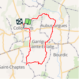
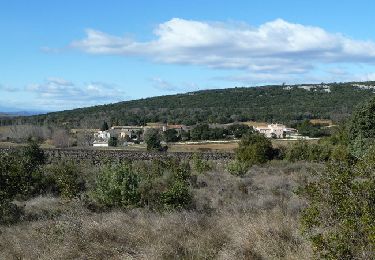
Trail Walking of 14.8 km to be discovered at Occitania, Gard, Collorgues. This trail is proposed by tracegps.

Description

Alternance de forêts et vignobles et passage à la Roche Gravée. Du parking du village, près d ela Mairie, partir vers l'est puis vers le sud pour aller à Sainte Eulalie. Après la visite du village, continuer toujours plein sud Rocher gravé, par un aller-retour. Cheminer parmi le vignoble et traverser "Garrigues" avant de trouver "Aubussargues" et son château. Passer à "la Madone", puis poursuivre par le "sentier des Ânes" avant de regagner le départ. Une rando facile sur de bons chemins.

Elevation profile

Photos

Positioning

Country:
France
Region :
Occitania
Department/Province :
Gard
Municipality :
Collorgues
Location:
Unknown
Start:(UTM)
603566 ; 4873210 (31T) N.

Trails nearby

Trail Walking Collorgues - Château de Castelnau - Collorgues - Photo
Walking
tracegps

Walking

Medium
(1)
Collorgues, Occitania, Gard, France
14.1 km | 17.3 km-effort
4h 0min
Yes
Trail Walking Collorgues - Collorgues dalles  - Photo
Walking
caroline116

Walking

Very easy
(1)
Collorgues, Occitania, Gard, France
7.9 km | 9.7 km-effort
46min
Yes
Trail Walking Collorgues - Aubussargues 2ème parcours - Photo
Walking
caroline116

Walking

Medium
(1)
Collorgues, Occitania, Gard, France
7 km | 8.8 km-effort
1h 50min
Yes
Trail Walking Collorgues - Aubussargues 2ème parcours - Photo
Walking
caroline116

Walking

Medium
(1)
Collorgues, Occitania, Gard, France
7 km | 8.8 km-effort
1h 50min
Yes
Trail Walking Saint-Chaptes - Rome-16-StChaptes-LaCalmette-20150903 - Photo
Walking
patrickdanilo

Walking

Easy
Saint-Chaptes, Occitania, Gard, France
18.8 km | 23 km-effort
4h 53min
No
Trail Mountain bike Collorgues - Château de Castelnau - Collorgues - Photo
Mountain bike
tracegps

Mountain bike

Easy
Collorgues, Occitania, Gard, France
14.1 km | 17.3 km-effort
1h 30min
Yes
Trail Walking Foissac - L'Arque de Baron - Foissac - Photo
Walking
tracegps

Walking

Medium
Foissac, Occitania, Gard, France
14.4 km | 17.6 km-effort
4h 0min
Yes
Trail Walking Bourdic - BOURDIC - Photo
Walking
bernardgouttiere

Walking

Easy
Bourdic, Occitania, Gard, France
13.3 km | 14.6 km-effort
4h 7min
Yes
Trail Mountain bike Saint-Chaptes - Boulanger St. Chapte - Photo
Mountain bike
andremusin

Mountain bike

Easy
Saint-Chaptes, Occitania, Gard, France
4.1 km | 4.6 km-effort
23min
No


Close
My subscriptions