Trail Walking Xonrupt-Longemer - SityTrail - La Roche des Chiens 13 300m +457m - Photo

SityTrail - La Roche des Chiens 13 300m +457m

© OpenStreetMap contributors
Length
Length
13.3 km
Max alt
Max alt
1088 m
Uphill gradient
Uphill gradient
457 m
Km-Effort
Km-Effort  
19.4 km
Min alt
Min alt
799 m
Downhill gradient
Downhill gradient
456 m
Boucle
Boucle
Yes
Creation date :
2022-04-15 14:02:25.039
Updated on :
2022-04-15 14:08:49.855

(0 Reviews)

Walking
Walking
4h24
Difficulty : Very difficult

Scan this QR Code to open this trail in the SityTrail application

FREE GPS app for hiking

Logo SityTrail SityTrail

IGN / Geographical institutes

Download SityTrail from the App Store Download SityTrail from Google Play

Logo SityTrail SityTrail World

The world is yours!

Download SityTrail from the App Store Download SityTrail from Google Play Download SityTrail on Huawei AppGallery

About

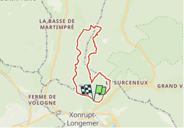
Trail Walking of 13.3 km to be discovered at Grand Est, Vosges, Xonrupt-Longemer. This trail is proposed by DanielROLLET.

Description

2021 09 24 - 9h15 à 15h45 - pauses et accident!  compris
Trés beau temps
Rando évaluation BF
6 participants : Isabelle, Jean-Luc, Claude, Sandrine, Daniel, Jean-Marc
2 formateurs : Jean-Luc et Bernard

Elevation profile

Positioning

Country:
France
Region :
Grand Est
Department/Province :
Vosges
Municipality :
Xonrupt-Longemer
Location:
Unknown
Start:(UTM)
346165 ; 5328283 (32U) N.

Trails nearby

Trail Walking La Bresse - Lac de Lispach et sentier Dielaine  - Photo
Walking
zazie

Walking

Medium
(1)
La Bresse, Grand Est, Vosges, France
9.7 km | 14.9 km-effort
2h 30min
Yes
Trail Walking Ban-sur-Meurthe-Clefcy - La vallée de Belbriette - Ban-sur-Meurthe-Clefcy - Photo
Walking
tracegps

Walking

Medium
(2)
Ban-sur-Meurthe-Clefcy, Grand Est, Vosges, France
9.8 km | 12.6 km-effort
2h 30min
Yes
Trail Walking Gérardmer - gerardmer - la mauselaine . tête grauvelin . Roche boquet . croix claudé . hautes Vannes . la mauselaine  - Photo
Walking
stef789

Walking

Very easy
(1)
Gérardmer, Grand Est, Vosges, France
11.3 km | 16.2 km-effort
3h 42min
Yes
Trail Walking Xonrupt-Longemer - 23-08-17 Lac Longemer - Lispach - Photo
Walking
annefrance70

Walking

Medium
(1)
Xonrupt-Longemer, Grand Est, Vosges, France
7 km | 12.1 km-effort
2h 13min
Yes
Trail Walking La Bresse - Lac de Lispach  - Photo
Walking
Bruca

Walking

Easy
(1)
La Bresse, Grand Est, Vosges, France
2.1 km | 2.4 km-effort
44min
Yes
Trail Walking Xonrupt-Longemer - Le Hohneck et le sentier des roches - Du lac de Longemer au lac de Schiessrothried - Photo
Walking
tracegps

Walking

Difficult
(1)
Xonrupt-Longemer, Grand Est, Vosges, France
15.7 km | 28 km-effort
7h 0min
No
Trail Snowshoes Xonrupt-Longemer - Tour du Lispach - Longemer - Photo
Snowshoes
tracegps

Snowshoes

Medium
(2)
Xonrupt-Longemer, Grand Est, Vosges, France
3.2 km | 6.6 km-effort
2h 0min
Yes
Trail Walking La Bresse - 2023-04-14 Marche Lac de Lispach vers Abri Collet de Etang - Photo
Walking
GUIDE
holtzv

Walking

Very easy
La Bresse, Grand Est, Vosges, France
5.6 km | 9 km-effort
2h 3min
No
Trail Walking Xonrupt-Longemer - Le tour du lac de longemer  - Photo
Walking
GUIDE+

Walking

Medium
Xonrupt-Longemer, Grand Est, Vosges, France
5.2 km | 6.1 km-effort
1h 22min
Yes


Close
My subscriptions