Trail Walking Arrien-en-Bethmale - Les granges de la Serre depuis Tournac-Bouche. - Photo

Les granges de la Serre depuis Tournac-Bouche.

 chrisgps
chrisgps

User

© OpenStreetMap contributors
Length
Length
14.6 km
Max alt
Max alt
1461 m
Uphill gradient
Uphill gradient
799 m
Km-Effort
Km-Effort  
25 km
Min alt
Min alt
716 m
Downhill gradient
Downhill gradient
808 m
Boucle
Boucle
Yes
Creation date :
2022-05-01 06:45:22.23
Updated on :
2022-05-02 15:01:04.884

(0 Reviews)

Walking
Walking
7h33
Difficulty : Medium

Scan this QR Code to open this trail in the SityTrail application

FREE GPS app for hiking

Logo SityTrail SityTrail

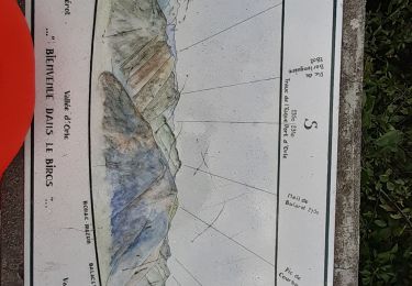
IGN / Geographical institutes

Download SityTrail from the App Store Download SityTrail from Google Play

Logo SityTrail SityTrail World

The world is yours!

Download SityTrail from the App Store Download SityTrail from Google Play Download SityTrail on Huawei AppGallery

About

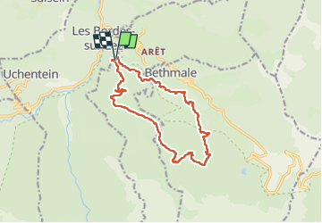
Trail Walking of 14.6 km to be discovered at Occitania, Ariège, Arrien-en-Bethmale. This trail is proposed by chrisgps.

Description

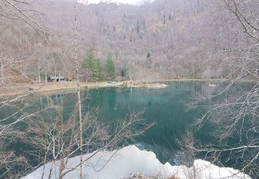
boucle "raccourcie" qui évite le lac de Bethmale.
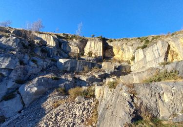
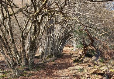
A la montée, à 2 reprises on "évite" la piste en prenant d'anciens chemins bien sûr plus entretenus.
Pour descendre, du parking du Mont Ner, on prend à gauche, l'ancienne piste que mène à la grange du même nom (pique-nique).On suit la lisière du bois jusqu'à la jonction avec le GR 10. Là, bifurcation tout à gauche  pour un "tout droit" pour rejoindre plus bas la piste forestière de MontNer (1230m).
Juste après le 2ème lacet et avant la ravine, repérer à gauche le départ d'un vieux chemin encombré mais "faisable" ou subsistent des balises "vert clair". C'est "un raccourci" qui nous ramène sur le GR10 un peu avant Salabert (grange rénovée).
Rencontre plus bas du canal qui va nous accompagner jusqu'à l'ancien gîte de La Bouche, notre point de départ.

Elevation profile

Photos

Positioning

Country:
France
Region :
Occitania
Department/Province :
Ariège
Municipality :
Arrien-en-Bethmale
Location:
Unknown
Start:(UTM)
339525 ; 4750708 (31T) N.

Trails nearby

Trail Walking Arrien-en-Bethmale - Les granges de la Serre depuis Tournac-La Bouche. - Photo
Walking
chrisgps

Walking

Medium
(1)
Arrien-en-Bethmale, Occitania, Ariège, France
15 km | 26 km-effort
6h 39min
Yes
Trail Walking Bethmale - Bethmale - Photo
Walking
Gepeto_22

Walking

Medium
(2)
Bethmale, Occitania, Ariège, France
5.4 km | 8.8 km-effort
2h 20min
Yes
Trail Walking Bethmale -  Circuit des cinq étangs (2237m) - Photo
Walking
tigrou31

Walking

Difficult
(3)
Bethmale, Occitania, Ariège, France
18.1 km | 33 km-effort
Unknown
Yes
Trail Walking Salsein - Cabane et pic de l'Arraing depuis Salsein - Photo
Walking
chrisgps

Walking

Medium
Salsein, Occitania, Ariège, France
11.7 km | 21 km-effort
4h 43min
Yes
Trail Walking Balacet - Pic de l'Arraing - Photo
Walking
counoise

Walking

Medium
Balacet, Occitania, Ariège, France
11.9 km | 24 km-effort
4h 7min
Yes
Trail Walking Bethmale - refuge Salvador - Photo
Walking
chrisgps

Walking

Very difficult
Bethmale, Occitania, Ariège, France
16 km | 25 km-effort
5h 46min
Yes
Trail Walking Bethmale - cap de l'auternac  en boucle - Photo
Walking
chrisgps

Walking

Difficult
Bethmale, Occitania, Ariège, France
15 km | 30 km-effort
7h 51min
Yes
Trail Walking Bethmale - etang bethmale - Photo
Walking
fbienmuller

Walking

Easy
(1)
Bethmale, Occitania, Ariège, France
12.2 km | 18.2 km-effort
3h 19min
Yes
Trail Walking Balacet - Col de l'Arraing - Photo
Walking
counoise

Walking

Medium
Balacet, Occitania, Ariège, France
7 km | 13 km-effort
2h 5min
Yes


Close
My subscriptions