Trail On foot Masevaux-Niederbruck - de Stoecken(Masevaux)au Lachtelweiher - Photo

de Stoecken(Masevaux)au Lachtelweiher

© OpenStreetMap contributors
Length
Length
23 km
Max alt
Max alt
1070 m
Uphill gradient
Uphill gradient
936 m
Km-Effort
Km-Effort  
35 km
Min alt
Min alt
468 m
Downhill gradient
Downhill gradient
941 m
Boucle
Boucle
Yes
Creation date :
2022-05-23 12:53:44.484
Updated on :
2022-05-23 13:07:27.48

(0 Reviews)

On foot
On foot
6h30
Difficulty : Medium

Scan this QR Code to open this trail in the SityTrail application

FREE GPS app for hiking

Logo SityTrail SityTrail

IGN / Geographical institutes

Download SityTrail from the App Store Download SityTrail from Google Play

Logo SityTrail SityTrail World

The world is yours!

Download SityTrail from the App Store Download SityTrail from Google Play Download SityTrail on Huawei AppGallery

About

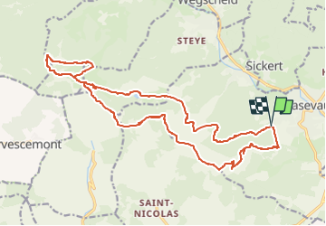
Trail On foot of 23 km to be discovered at Grand Est, Haut-Rhin, Masevaux-Niederbruck. This trail is proposed by senn francis.

Description

départ de Stoecken/auberge de Bruckenwald/Lachtelweiher/
auberge de la Fennemat/piste de la Schlumpf/la Fennematt
Baerenkopf/le Sudel/maison de convalescence/Stoecken

Elevation profile

Positioning

Country:
France
Region :
Grand Est
Department/Province :
Haut-Rhin
Municipality :
Masevaux-Niederbruck
Location:
Masevaux
Start:(UTM)
348771 ; 5292653 (32T) N.

Trails nearby

Trail Walking Masevaux-Niederbruck - Masevaux - Rossberg par le belvédère du Fuchsfelsen - Photo
Walking
Bart2015

Walking

Medium
(1)
Masevaux-Niederbruck, Grand Est, Haut-Rhin, France
19.9 km | 34 km-effort
4h 44min
Yes
Trail Walking Bourbach-le-Haut - 2024-01-12_14h17m14_239006910 - Photo
Walking
GUIDE
mumu.larandonneuse

Walking

Difficult
Bourbach-le-Haut, Grand Est, Haut-Rhin, France
11.4 km | 18.5 km-effort
4h 12min
Yes
Trail Walking Kirchberg - 2022-07-15 Marche Refuge Baerenkopf Auberge Gazon Vert - Photo
Walking
GUIDE
holtzv

Walking

Very difficult
Kirchberg, Grand Est, Haut-Rhin, France
23 km | 38 km-effort
8h 21min
No
Trail Walking Lauw - 2022-07-14 Marche Lauw Refuge CAF Baerenkopf - Photo
Walking
GUIDE
holtzv

Walking

Very difficult
Lauw, Grand Est, Haut-Rhin, France
18.4 km | 31 km-effort
5h 35min
No
Trail On foot Sentheim - Sentheim - Bergwald - Eichwald - Guevenheim - Sentheim - Photo
On foot
patrickbeyrath

On foot

Easy
(1)
Sentheim, Grand Est, Haut-Rhin, France
13.4 km | 16.6 km-effort
Unknown
Yes
Trail Walking Bitschwiller-lès-Thann - 68 Col du Hundsrück  - FA Gsang - retour ThannerHubel - Photo
Walking

Walking

Medium
(1)
Bitschwiller-lès-Thann, Grand Est, Haut-Rhin, France
11.2 km | 18.4 km-effort
3h 48min
Yes
Trail Walking Masevaux-Niederbruck - Rando CLAS du 25/04/2024 - Photo
Walking
boubou68

Walking

Very difficult
Masevaux-Niederbruck, Grand Est, Haut-Rhin, France
17 km | 28 km-effort
4h 24min
Yes
Trail Walking Kirchberg - Rando du 11/04/2024  ..Marcheurs - Photo
Walking
boubou68

Walking

Very difficult
Kirchberg, Grand Est, Haut-Rhin, France
23 km | 37 km-effort
5h 37min
Yes
Trail Walking Kirchberg - Sommerseite 2023 - Photo
Walking
helmut68

Walking

Difficult
Kirchberg, Grand Est, Haut-Rhin, France
13.5 km | 21 km-effort
4h 12min
Yes


Close
My subscriptions