Trail On foot Chauchailles - 2022-05-31_19h34m27_gpx-trace - Photo

2022-05-31_19h34m27_gpx-trace

 audier
audier

User

© OpenStreetMap contributors
Length
Length
22 km
Max alt
Max alt
1034 m
Uphill gradient
Uphill gradient
683 m
Km-Effort
Km-Effort  
31 km
Min alt
Min alt
749 m
Downhill gradient
Downhill gradient
685 m
Boucle
Boucle
Yes
Creation date :
2022-05-31 17:34:27.587
Updated on :
2022-06-01 17:30:28.178

(1 Reviews)

On foot
On foot
7h07
Difficulty : Difficult

Scan this QR Code to open this trail in the SityTrail application

FREE GPS app for hiking

Logo SityTrail SityTrail

IGN / Geographical institutes

Download SityTrail from the App Store Download SityTrail from Google Play

Logo SityTrail SityTrail World

The world is yours!

Download SityTrail from the App Store Download SityTrail from Google Play Download SityTrail on Huawei AppGallery

About

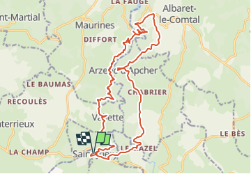
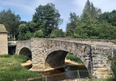
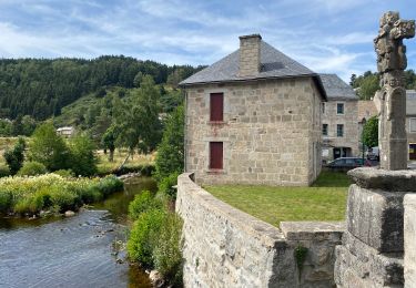
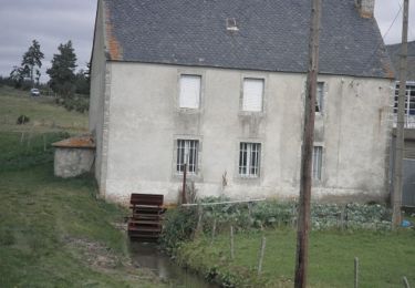
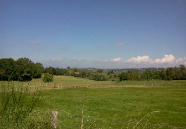
Trail On foot of 22 km to be discovered at Occitania, Lozère, Chauchailles. This trail is proposed by audier.

Description

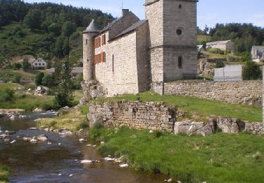
Circuit au départ de Saint Juéry(48),vous mènera au site médiéval de Arzenc d'Apcher,puis un sentier balcon qui domine les gorges de BES. Randonnée proposée par FFRP.

Elevation profile

Positioning

Country:
France
Region :
Occitania
Department/Province :
Lozère
Municipality :
Chauchailles
Location:
Unknown
Start:(UTM)
506696 ; 4963592 (31T) N.

Comments

Please log in to post a review or rate the element


Trails nearby

Trail Walking Maurines - LES GORGES DU BES - Photo
Walking
Phil36

Walking

Medium
(1)
Maurines, Auvergne-Rhône-Alpes, Cantal, France
6.5 km | 9.2 km-effort
2h 5min
Yes
Trail Walking Chauchailles - sentier des espagnols  - Photo
Walking
GUIDE
nadinebondoux

Walking

Difficult
Chauchailles, Occitania, Lozère, France
22 km | 32 km-effort
6h 48min
Yes
Trail Walking Chauchailles - Gorges du Bèz sentier des espagnols - Photo
Walking
GUIDE
Roger Philippe Wallez

Walking

Very difficult
Chauchailles, Occitania, Lozère, France
22 km | 31 km-effort
7h 34min
Yes
Trail Walking Fournels - De Fournels  à St-Chély-d'Apcher - Photo
Walking
tracegps

Walking

Difficult
Fournels, Occitania, Lozère, France
17.7 km | 23 km-effort
4h 10min
No
Trail Walking Chauchailles - Les Gorges du Bes - Photo
Walking
tracegps

Walking

Difficult
(1)
Chauchailles, Occitania, Lozère, France
21 km | 30 km-effort
7h 0min
Yes
Trail Walking Maurines - le bez,départ de Morsange  - Photo
Walking
GILOU440

Walking

Medium
Maurines, Auvergne-Rhône-Alpes, Cantal, France
6.6 km | 9.3 km-effort
2h 45min
Yes
Trail Walking Saint-Juéry - Le Bes - Photo
Walking
viam19

Walking

Difficult
Saint-Juéry, Occitania, Lozère, France
15.3 km | 21 km-effort
7h 20min
Yes
Trail Walking Deux-Verges - Le Puy de la Tuile - Photo
Walking
neitag61

Walking

Medium
Deux-Verges, Auvergne-Rhône-Alpes, Cantal, France
8.9 km | 12.5 km-effort
3h 0min
Yes
Trail Walking Maurines - Les Gorges du Bès - Maurines - Photo
Walking
helmut68

Walking

Easy
Maurines, Auvergne-Rhône-Alpes, Cantal, France
7.9 km | 12.9 km-effort
2h 42min
Yes


Close
My subscriptions