Trail Walking Lurs - lurs à pierrerue.  Le chemin de compostelle  - Photo

lurs à pierrerue. Le chemin de compostelle

 Roger
Roger

User

© OpenStreetMap contributors
Length
Length
8.8 km
Max alt
Max alt
550 m
Uphill gradient
Uphill gradient
174 m
Km-Effort
Km-Effort  
11.2 km
Min alt
Min alt
406 m
Downhill gradient
Downhill gradient
179 m
Boucle
Boucle
Yes
Creation date :
2022-07-08 06:02:36.294
Updated on :
2022-07-08 08:45:56.987

(0 Reviews)

Walking
Walking
2h32
Difficulty : Medium

Scan this QR Code to open this trail in the SityTrail application

FREE GPS app for hiking

Logo SityTrail SityTrail

IGN / Geographical institutes

Download SityTrail from the App Store Download SityTrail from Google Play

Logo SityTrail SityTrail World

The world is yours!

Download SityTrail from the App Store Download SityTrail from Google Play Download SityTrail on Huawei AppGallery

About

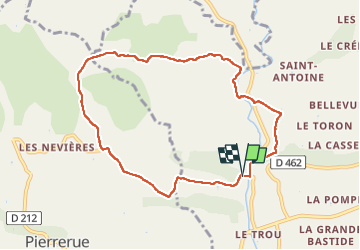
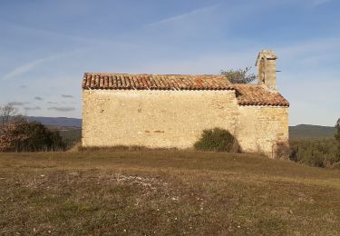
Trail Walking of 8.8 km to be discovered at Provence-Alpes-Côte d'Azur, Alpes-de-Haute-Provence, Lurs. This trail is proposed by Roger .

Description

démarrer la randonnée depuis le hameau.  on peut s arrêter au moulin à huile de ventre pour acheter ou visiter sur réservation

Elevation profile

Photos

Positioning

Country:
France
Region :
Provence-Alpes-Côte d'Azur
Department/Province :
Alpes-de-Haute-Provence
Municipality :
Lurs
Location:
Unknown
Start:(UTM)
729825 ; 4871874 (31T) N.

Trails nearby

Trail Mountain bike Lurs - Lurs/Tour de la Beaume - Photo
Mountain bike
remizzi

Mountain bike

Medium
(2)
Lurs, Provence-Alpes-Côte d'Azur, Alpes-de-Haute-Provence, France
18.5 km | 24 km-effort
2h 40min
Yes
Trail Walking Ganagobie - 2024-02-27 Ganagobie  - Photo
Walking
GUIDE
Kargil

Walking

Easy
Ganagobie, Provence-Alpes-Côte d'Azur, Alpes-de-Haute-Provence, France
10.2 km | 15.1 km-effort
3h 25min
Yes
Trail Walking Oraison - 2023-01-13 Oraison - La Baume - Photo
Walking
GUIDE
Kargil

Walking

Very easy
Oraison, Provence-Alpes-Côte d'Azur, Alpes-de-Haute-Provence, France
13.8 km | 18.6 km-effort
6h 38min
Yes
Trail On foot Ganagobie - La Forêt du Prieuré - Photo
On foot
PRO

On foot

Easy
Ganagobie, Provence-Alpes-Côte d'Azur, Alpes-de-Haute-Provence, France
10.2 km | 15.3 km-effort
3h 28min
No
Trail Walking Lurs - ganagobie - Photo
Walking
MicDul

Walking

Very difficult
Lurs, Provence-Alpes-Côte d'Azur, Alpes-de-Haute-Provence, France
15.9 km | 23 km-effort
5h 17min
Yes
Trail Walking Lurs - LURS  Visite et tour de Lurs o l m s  - Photo
Walking
RobinMicheline

Walking

Medium
(2)
Lurs, Provence-Alpes-Côte d'Azur, Alpes-de-Haute-Provence, France
11.1 km | 15.6 km-effort
3h 17min
Yes
Trail Walking Sigonce - Boucle du Grand Champ depart Sigonce 382+ - Photo
Walking
claude nier

Walking

Easy
Sigonce, Provence-Alpes-Côte d'Azur, Alpes-de-Haute-Provence, France
12.6 km | 17.7 km-effort
4h 27min
Yes
Trail Walking Ganagobie - Ganagobie - Photo
Walking
Daniel DUPONT-HAMMOND

Walking

Ganagobie, Provence-Alpes-Côte d'Azur, Alpes-de-Haute-Provence, France
13.7 km | 18.8 km-effort
4h 22min
No
Trail On foot Lurs - LURS . bois du Crepon , Notre dame du Plan , la Casse o - Photo
On foot
RobinMicheline

On foot

Medium
Lurs, Provence-Alpes-Côte d'Azur, Alpes-de-Haute-Provence, France
14.3 km | 18.6 km-effort
Unknown
Yes


Close
My subscriptions