Trail Walking Chalais - 2022 - Crêt du midi, vallon de rechy, bisse de vercorin - Photo

2022 - Crêt du midi, vallon de rechy, bisse de vercorin

© OpenStreetMap contributors
Length
Length
15.4 km
Max alt
Max alt
2321 m
Uphill gradient
Uphill gradient
223 m
Km-Effort
Km-Effort  
22 km
Min alt
Min alt
1304 m
Downhill gradient
Downhill gradient
1232 m
Boucle
Boucle
No
Creation date :
2022-07-20 07:18:32.08
Updated on :
2022-08-03 12:15:31.389

(0 Reviews)

Walking
Walking
7h36
Difficulty : Very difficult

Scan this QR Code to open this trail in the SityTrail application

FREE GPS app for hiking

Logo SityTrail SityTrail

IGN / Geographical institutes

Download SityTrail from the App Store Download SityTrail from Google Play

Logo SityTrail SityTrail World

The world is yours!

Download SityTrail from the App Store Download SityTrail from Google Play Download SityTrail on Huawei AppGallery

About

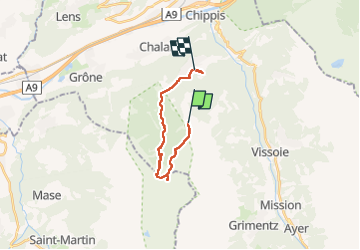
Trail Walking of 15.4 km to be discovered at Valais/Wallis, Sierre, Chalais. This trail is proposed by Celine1217.

Description

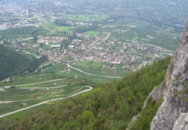
Jolie randonnée très variée. Assez long, beaucoup de descentes raides.
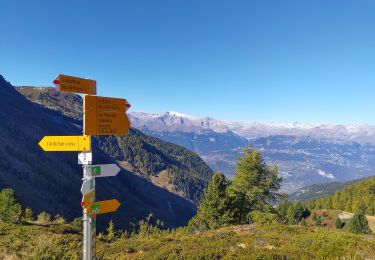
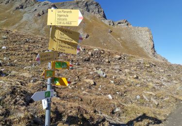
Le tracé que j'avais était très imprécis, et il n'y a pas beaucoup d'indications sur place. Après la cascade, ne pas suivre ma trace mais rester sur la rive gauche. Le sentier que j'ai pris est très mauvais et pas spécialement joli (j'ai vu une fois en bas que tout le monde arrivait par l'autre côté.. j'aurais préféré le savoir avant...)

Ok chiens mais laisse obligatoire jusqu'au bisse (réserve naturelle) et c'est ch...t, surtout en descente.
Beaucoup de points d'eau pour les toutous.

Elevation profile

Points of interest

Point of interest Grône - Sentier alternatif - Photo
Celine1217
Point of interest Grône - Buvette  - Photo
Celine1217
GRÔNE 

Positioning

Country:
Switzerland
Region :
Valais/Wallis
Department/Province :
Sierre
Municipality :
Chalais
Location:
Unknown
Start:(UTM)
386601 ; 5120571 (32T) N.

Trails nearby

Trail On foot Mont-Noble - La Combe - Nax - Photo
On foot
PRO

On foot

Easy
Mont-Noble, Valais/Wallis, Hérens, Switzerland
6.3 km | 9.8 km-effort
2h 13min
No
Trail On foot Chalais - Les Planards-L'Ar du Tsan - Photo
On foot
PRO

On foot

Easy
Chalais, Valais/Wallis, Sierre, Switzerland
4.8 km | 6.7 km-effort
1h 31min
No
Trail On foot Chalais - La Lé-refuge du Bisse - Photo
On foot
PRO

On foot

Easy
Chalais, Valais/Wallis, Sierre, Switzerland
3.2 km | 5 km-effort
1h 7min
No
Trail On foot Mont-Noble - L'Ar du Tsan - Le Louché Lac (B) - Photo
On foot
PRO

On foot

Easy
Mont-Noble, Valais/Wallis, Hérens, Switzerland
4.1 km | 8 km-effort
1h 49min
No
Trail Walking Crans-Montana - Chemin du Vignoble - Itinéraire dégustation - Photo
Walking
GUIDE+

Walking

Very easy
Crans-Montana, Valais/Wallis, Sierre, Switzerland
7 km | 10.2 km-effort
2h 45min
No
Trail Walking Chalais - Crêt du Midi - Ar du Tsan- Bisse Vercorin - Photo
Walking
vercorin

Walking

Very easy
(1)
Chalais, Valais/Wallis, Sierre, Switzerland
11.4 km | 17 km-effort
3h 46min
No
Trail On foot Anniviers - Grand Bisse de St-Jean - Photo
On foot
PRO

On foot

Easy
Anniviers, Valais/Wallis, Sierre, Switzerland
5 km | 8.4 km-effort
1h 54min
No
Trail On foot Grône - Mayens de Réchy-Brie - Photo
On foot
PRO

On foot

Easy
Grône, Valais/Wallis, Sierre, Switzerland
6.3 km | 11.2 km-effort
2h 32min
No
Trail Walking Chalais - vs_hike605e - Photo
Walking
GUIDE+

Walking

Very easy
Chalais, Valais/Wallis, Sierre, Switzerland
14.7 km | 24 km-effort
4h 23min
Yes


Close
My subscriptions