


soultzeren la Schlucht

gamille67
User
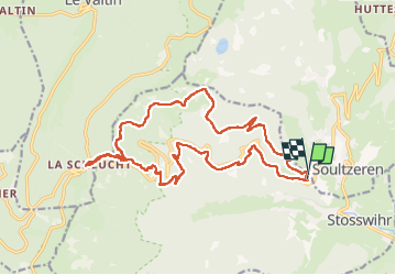

Length
21 km

Max alt
1244 m

Uphill gradient
822 m
Km-Effort
32 km

Min alt
694 m

Downhill gradient
811 m
Boucle
Yes
Creation date :
2020-10-27 09:32:08.934
Updated on :
2022-08-01 17:08:49.094
4h51
Difficulty : Medium

FREE GPS app for hiking
 SityTrail
IGN / Geographical institutes
SityTrail Plus
The world is yours!
About
Trail Walking of 21 km to be discovered at Grand Est, Haut-Rhin, Stosswihr. This trail is proposed by gamille67.
Positioning
Country:
France
Region :
Grand Est
Department/Province :
Haut-Rhin
Municipality :
Stosswihr
Location:
Unknown
Start:(Dec)
Start:(UTM)
357721 ; 5324816 (32U) N.
Comments