Trail Walking Sus - Boucle Sus - Photo
© OpenStreetMap contributors
Length
Length
13.1 km
Max alt
Max alt
257 m
Uphill gradient
Uphill gradient
258 m
Km-Effort
Km-Effort  
16.5 km
Min alt
Min alt
131 m
Downhill gradient
Downhill gradient
257 m
Boucle
Boucle
Yes
Creation date :
2022-08-14 14:35:19.0
Updated on :
2022-08-14 17:46:57.17

(0 Reviews)

Walking
Walking
2h28
Difficulty : Easy

Scan this QR Code to open this trail in the SityTrail application

FREE GPS app for hiking

Logo SityTrail SityTrail

IGN / Geographical institutes

Download SityTrail from the App Store Download SityTrail from Google Play

Logo SityTrail SityTrail World

The world is yours!

Download SityTrail from the App Store Download SityTrail from Google Play Download SityTrail on Huawei AppGallery

About

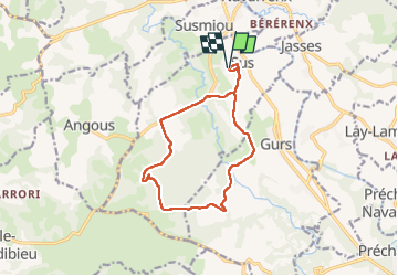
Trail Walking of 13.1 km to be discovered at New Aquitaine, Pyrénées-Atlantiques, Sus. This trail is proposed by Fabichette.

Description

Jolie randonnée dans la campagne forestière du Béarn des gaves. Aucune difficulté

Elevation profile

Photos

Positioning

Country:
France
Region :
New Aquitaine
Department/Province :
Pyrénées-Atlantiques
Municipality :
Sus
Location:
Unknown
Start:(UTM)
680923 ; 4797170 (30T) N.

Trails nearby

Trail Walking Navarrenx - NAVARRENX Terra aventura
Walking
GUIDE
marmotte65

Walking

Easy
Navarrenx, New Aquitaine, Pyrénées-Atlantiques, France
1.7 km | 1.8 km-effort
25min
Yes
Trail Walking Gurs - De Gurs à Araujuzon - Photo
Walking
tracegps

Walking

Medium
Gurs, New Aquitaine, Pyrénées-Atlantiques, France
19.9 km | 25 km-effort
4h 0min
No
Trail Walking Navarrenx - Camino 1 étape 29 - Photo
Walking
bene_dictus77

Walking

Medium
Navarrenx, New Aquitaine, Pyrénées-Atlantiques, France
21 km | 25 km-effort
7h 4min
No
Trail Walking Navarrenx - Compostelle 31 - Navarrenx -> St-Palais - Photo
Walking
uru2010

Walking

Difficult
Navarrenx, New Aquitaine, Pyrénées-Atlantiques, France
39 km | 48 km-effort
8h 18min
No
Trail Bicycle tourism Navarrenx - B - Navarrenx - Béarn des gaves Perso - Photo
Bicycle tourism
potofe

Bicycle tourism

Difficult
Navarrenx, New Aquitaine, Pyrénées-Atlantiques, France
58 km | 68 km-effort
Unknown
Yes
Trail Walking Navarrenx - St Jacques Etape 34 - Photo
Walking
Jean-MarieFaux

Walking

Easy
Navarrenx, New Aquitaine, Pyrénées-Atlantiques, France
18.7 km | 23 km-effort
4h 57min
No
Trail Walking Navarrenx - Navarrenx-Saint-Palais (Aroue) - Photo
Walking
chouk1

Walking

Medium
Navarrenx, New Aquitaine, Pyrénées-Atlantiques, France
22 km | 26 km-effort
5h 38min
No
Trail Walking Navarrenx - navarenx/lichos - Photo
Walking
puchol

Walking

Easy
Navarrenx, New Aquitaine, Pyrénées-Atlantiques, France
17.6 km | 21 km-effort
4h 35min
No
Trail Bicycle tourism Navarrenx - B - Navarrrenx - Béarn des gaves - Photo
Bicycle tourism
potofe

Bicycle tourism

Medium
Navarrenx, New Aquitaine, Pyrénées-Atlantiques, France
67 km | 81 km-effort
Unknown
Yes


Close
My subscriptions