


Doucy

91eric91
User
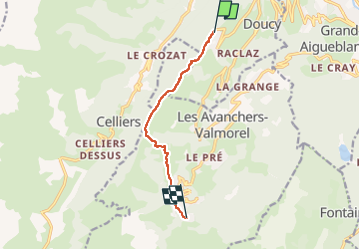

Length
6.9 km

Max alt
1563 m

Uphill gradient
409 m
Km-Effort
11.7 km

Min alt
1270 m

Downhill gradient
219 m
Boucle
No
Creation date :
2022-08-17 12:41:51.0
Updated on :
2022-08-17 14:22:32.218
1h40
Difficulty : Medium

FREE GPS app for hiking
 SityTrail
IGN / Geographical institutes
SityTrail Plus
The world is yours!
About
Trail Walking of 6.9 km to be discovered at Auvergne-Rhône-Alpes, Savoy, La Léchère. This trail is proposed by 91eric91.
Positioning
Country:
France
Region :
Auvergne-Rhône-Alpes
Department/Province :
Savoy
Municipality :
La Léchère
Location:
Doucy
Start:(Dec)
Start:(UTM)
301056 ; 5041729 (32T) N.
Comments