Trail Walking Enchastrayes - Aupillon-cabane basse 04 - Photo
© OpenStreetMap contributors
Length
Length
11.1 km
Max alt
Max alt
1936 m
Uphill gradient
Uphill gradient
521 m
Km-Effort
Km-Effort  
18 km
Min alt
Min alt
1440 m
Downhill gradient
Downhill gradient
524 m
Boucle
Boucle
Yes
Creation date :
2022-08-21 09:21:51.285
Updated on :
2022-08-21 15:40:23.17

(0 Reviews)

Walking
Walking
3h24
Difficulty : Difficult

Scan this QR Code to open this trail in the SityTrail application

FREE GPS app for hiking

Logo SityTrail SityTrail

IGN / Geographical institutes

Download SityTrail from the App Store Download SityTrail from Google Play

Logo SityTrail SityTrail World

The world is yours!

Download SityTrail from the App Store Download SityTrail from Google Play Download SityTrail on Huawei AppGallery

About

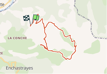
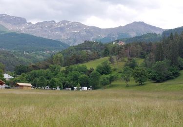
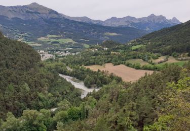
Trail Walking of 11.1 km to be discovered at Provence-Alpes-Côte d'Azur, Alpes-de-Haute-Provence, Enchastrayes. This trail is proposed by janussity.

Description

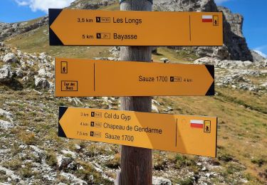
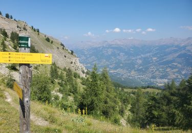
Depuis les Patigons, en groupe jusqu'à l'Aupillon et déjeuner. Ensuite à 4 jusqu'à cabane basse en marchant à travers pré et forêt. Retour chemin.

Elevation profile

Photos

Positioning

Country:
France
Region :
Provence-Alpes-Côte d'Azur
Department/Province :
Alpes-de-Haute-Provence
Municipality :
Enchastrayes
Location:
Unknown
Start:(UTM)
317033 ; 4917228 (32T) N.

Trails nearby

Trail Walking Faucon-de-Barcelonnette - Pre de RATA et St Flavie - Photo
Walking
andre06130

Walking

Difficult
(1)
Faucon-de-Barcelonnette, Provence-Alpes-Côte d'Azur, Alpes-de-Haute-Provence, France
7.8 km | 13.4 km-effort
3h 7min
Yes
Trail Mountain bike Barcelonnette - Le Bonnet Vert VTT - Photo
Mountain bike
Gouze13

Mountain bike

Medium
(1)
Barcelonnette, Provence-Alpes-Côte d'Azur, Alpes-de-Haute-Provence, France
18.7 km | 28 km-effort
2h 30min
Yes
Trail Walking Enchastrayes - chapeau de gendarme. Ubaye  - Photo
Walking
ytenag

Walking

Difficult
(1)
Enchastrayes, Provence-Alpes-Côte d'Azur, Alpes-de-Haute-Provence, France
16 km | 31 km-effort
7h 30min
Yes
Trail Mountain bike Jausiers - Espace VTT FFC Vallée de l'Ubaye - Circuit n° 01 - La Tour des Sagnes - Photo
Mountain bike
tracegps

Mountain bike

Very difficult
(1)
Jausiers, Provence-Alpes-Côte d'Azur, Alpes-de-Haute-Provence, France
31 km | 45 km-effort
4h 0min
Yes
Trail Walking Barcelonnette - La Salce/Pisse Vin/ les allemands - Photo
Walking
andre06130

Walking

Medium
(2)
Barcelonnette, Provence-Alpes-Côte d'Azur, Alpes-de-Haute-Provence, France
5.1 km | 8.2 km-effort
1h 45min
Yes
Trail Walking Enchastrayes - PETIT TOUR A BARCELONNETTE - Photo
Walking
walrou63

Walking

Medium
Enchastrayes, Provence-Alpes-Côte d'Azur, Alpes-de-Haute-Provence, France
7.3 km | 8.8 km-effort
2h 20min
Yes
Trail Walking Enchastrayes - chapeau de gendarme - Photo
Walking
gibello

Walking

Medium
Enchastrayes, Provence-Alpes-Côte d'Azur, Alpes-de-Haute-Provence, France
13.5 km | 28 km-effort
6h 51min
Yes
Trail Walking Jausiers - Petite ballade autour du pas de Grégoire  - Photo
Walking
andre06130

Walking

Medium
Jausiers, Provence-Alpes-Côte d'Azur, Alpes-de-Haute-Provence, France
4.7 km | 7.9 km-effort
1h 17min
Yes
Trail Walking Enchastrayes - col du Chapeau de gendarme et de Gyp Aller via flanc est Retour via flanc nord - Photo
Walking
cyrgab

Walking

Difficult
Enchastrayes, Provence-Alpes-Côte d'Azur, Alpes-de-Haute-Provence, France
11.4 km | 25 km-effort
4h 29min
Yes


Close
My subscriptions