


2022 Falimont Blaufels

staubalex
User
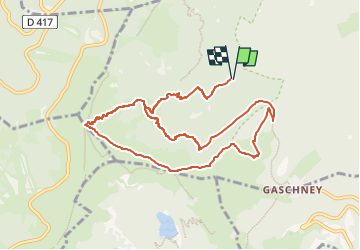

Length
10.9 km

Max alt
1341 m

Uphill gradient
623 m
Km-Effort
19.2 km

Min alt
830 m

Downhill gradient
621 m
Boucle
Yes
Creation date :
2022-09-30 07:01:41.957
Updated on :
2022-09-30 07:03:09.554
4h21
Difficulty : Very difficult

FREE GPS app for hiking
 SityTrail
IGN / Geographical institutes
SityTrail Plus
The world is yours!
About
Trail Walking of 10.9 km to be discovered at Grand Est, Haut-Rhin, Stosswihr. This trail is proposed by staubalex.
Positioning
Country:
France
Region :
Grand Est
Department/Province :
Haut-Rhin
Municipality :
Stosswihr
Location:
Unknown
Start:(Dec)
Start:(UTM)
353660 ; 5323385 (32U) N.
Comments