Trail Walking Coulommiers - TEM77 en ligne v3 - Photo

Les randos de la TEM77

© OpenStreetMap contributors
Length
Length
52 km
Max alt
Max alt
138 m
Uphill gradient
Uphill gradient
588 m
Km-Effort
Km-Effort  
60 km
Min alt
Min alt
58 m
Downhill gradient
Downhill gradient
551 m
Boucle
Boucle
No
Creation date :
2022-12-16 18:06:32.726
Updated on :
2022-12-16 18:06:32.726

(0 Reviews)

Walking
Walking
2h53
Difficulty : Difficult

Scan this QR Code to open this trail in the SityTrail application

FREE GPS app for hiking

Logo SityTrail SityTrail

IGN / Geographical institutes

Download SityTrail from the App Store Download SityTrail from Google Play

Logo SityTrail SityTrail World

The world is yours!

Download SityTrail from the App Store Download SityTrail from Google Play Download SityTrail on Huawei AppGallery

About

Trail Walking of 52 km to be discovered at Ile-de-France, Seine-et-Marne, Coulommiers. This trail is proposed by TEM77.

Elevation profile

Positioning

Country:
France
Region :
Ile-de-France
Department/Province :
Seine-et-Marne
Municipality :
Coulommiers
Location:
Unknown
Start:(UTM)
505426 ; 5406547 (31U) N.

Trails nearby

Trail Mountain bike Chailly-en-Brie - Espace VTT FFC - Les Coteaux du Morin et de l'Aubetin - Circuit n° 17 - Boucle1 - Photo
Mountain bike
tracegps

Mountain bike

Difficult
(1)
Chailly-en-Brie, Ile-de-France, Seine-et-Marne, France
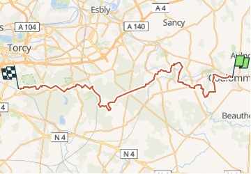
50 km | 57 km-effort
4h 30min
Yes
Trail Other activity Coulommiers - coulommiers  - Photo
Other activity
bellicaud

Other activity

Easy
(1)
Coulommiers, Ile-de-France, Seine-et-Marne, France
19 km | 23 km-effort
5h 0min
Yes
Trail Mountain bike Saint-Augustin - Espace VTT FFC - Les Coteaux du Morin et de l'Aubetin - Circuit n° 15 - Saint Augustin - Photo
Mountain bike
tracegps

Mountain bike

Medium
(1)
Saint-Augustin, Ile-de-France, Seine-et-Marne, France
12 km | 14.4 km-effort
1h 0min
Yes
Trail Walking Coulommiers - COULOMMIERS > FAREMOUTIERS 18 KM - Photo
Walking
gemau77

Walking

Very easy
(1)
Coulommiers, Ile-de-France, Seine-et-Marne, France
18.2 km | 22 km-effort
4h 40min
No
Trail Walking Coulommiers - Commanderie de COULOMMIERS - Photo
Walking
pikibangi

Walking

Medium
(3)
Coulommiers, Ile-de-France, Seine-et-Marne, France
12.9 km | 15.4 km-effort
3h 9min
Yes
Trail Walking Coulommiers - Coulommiers/Aunoy - Photo
Walking
pikibangi

Walking

Very difficult
Coulommiers, Ile-de-France, Seine-et-Marne, France
23 km | 27 km-effort
5h 21min
Yes
Trail Walking Pommeuse - balade au départ de Pommeuse - Photo
Walking
choubaka77

Walking

Easy
Pommeuse, Ile-de-France, Seine-et-Marne, France
31 km | 37 km-effort
3h 59min
No
Trail Walking Coulommiers - A l'est de Coulommiers - Photo
Walking
PatRando

Walking

Medium
Coulommiers, Ile-de-France, Seine-et-Marne, France
16.5 km | 19.1 km-effort
2h 57min
Yes
Trail Walking Coulommiers - A l'Ouest de Coulommiers  - Photo
Walking
PatRando

Walking

Easy
Coulommiers, Ile-de-France, Seine-et-Marne, France
12.8 km | 14.6 km-effort
2h 28min
Yes


Close
My subscriptions