Trail Walking Xonrupt-Longemer - Le tour du lac de longemer  - Photo

Le tour du lac de longemer

« L’heure de la fin des découvertes ne sonne jamais. » Colette GUIDE+

© OpenStreetMap contributors
Length
Length
5.2 km
Max alt
Max alt
764 m
Uphill gradient
Uphill gradient
65 m
Km-Effort
Km-Effort  
6.1 km
Min alt
Min alt
732 m
Downhill gradient
Downhill gradient
64 m
Boucle
Boucle
Yes
Creation date :
2023-01-29 21:14:16.618
Updated on :
2023-01-29 21:17:54.732

(0 Reviews)

Walking
Walking
1h22
Difficulty : Medium

Scan this QR Code to open this trail in the SityTrail application

FREE GPS app for hiking

Logo SityTrail SityTrail

IGN / Geographical institutes

Download SityTrail from the App Store Download SityTrail from Google Play

Logo SityTrail SityTrail World

The world is yours!

Download SityTrail from the App Store Download SityTrail from Google Play Download SityTrail on Huawei AppGallery

About

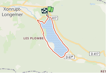
Trail Walking of 5.2 km to be discovered at Grand Est, Vosges, Xonrupt-Longemer. This trail is proposed by Au fil de nos découvertes.

Description

Quel magnifique endroit! 😱🥰

🅿️ Départ et Parking:
Route de la Plage,
88400 Xonrupt-Longemer, France

▶️ Aucune balise
🥾 Prévoir de bonnes chaussures de marche.

Le départ de cette magnifique promenade, dans le parc naturel des ballons des Vosges, vous emmène autour du lac de Longemer. 👌
Vous découvrirez la Chapelle Saint-Florent mais également de magnifiques vues donnant sur le lac. ❤️
De nombreux bancs sont présents sur le parcours. 🤗
- Petit bémol, un peu trop de route à notre goût.

Possibilités de pique-niquer. 🥪🍴
Chiens autorisés en laisse. 🐩🐶🐕
Convient pour les enfants. 👱👱‍♂️
Ne convient pas pour les poussettes et personnes à mobilité réduite. 👨‍🦽👩‍🦽👶

N'hésitez pas à aller faire un tour sur notre site internet : www.aufildenosdecouvertes.com

Instagram :
https://instagram.com/au_fil_de_nos_decouvertes…  

Elevation profile

Photos

43 photos in total. Please click on a photo to see them all in the gallery.

Positioning

Country:
France
Region :
Grand Est
Department/Province :
Vosges
Municipality :
Xonrupt-Longemer
Location:
Unknown
Start:(UTM)
347058 ; 5327185 (32U) N.

Trails nearby

Trail Walking La Bresse - Lac de Lispach et sentier Dielaine  - Photo
Walking
zazie

Walking

Medium
(1)
La Bresse, Grand Est, Vosges, France
9.7 km | 14.9 km-effort
2h 30min
Yes
Trail Walking La Bresse - Les 5 lacs autour du Hohneck - Photo
Walking
tiene

Walking

Very difficult
(1)
La Bresse, Grand Est, Vosges, France
21 km | 36 km-effort
7h 21min
Yes
Trail Walking La Bresse - lac de Lispach - Photo
Walking
fedinois1

Walking

Easy
(1)
La Bresse, Grand Est, Vosges, France
10.4 km | 14.1 km-effort
4h 6min
Yes
Trail Walking La Bresse - lac de Lispach - Photo
Walking
fedinois1

Walking

Easy
(3)
La Bresse, Grand Est, Vosges, France
10.4 km | 14.1 km-effort
4h 6min
Yes
Trail Walking Ban-sur-Meurthe-Clefcy - La vallée de Belbriette - Ban-sur-Meurthe-Clefcy - Photo
Walking
tracegps

Walking

Medium
(2)
Ban-sur-Meurthe-Clefcy, Grand Est, Vosges, France
9.8 km | 12.6 km-effort
2h 30min
Yes
Trail Walking Gérardmer - gerardmer - la mauselaine . tête grauvelin . Roche boquet . croix claudé . hautes Vannes . la mauselaine  - Photo
Walking
stef789

Walking

Very easy
(1)
Gérardmer, Grand Est, Vosges, France
11.3 km | 16.2 km-effort
3h 42min
Yes
Trail Walking Xonrupt-Longemer - 23-08-17 Lac Longemer - Lispach - Photo
Walking
annefrance70

Walking

Medium
(1)
Xonrupt-Longemer, Grand Est, Vosges, France
7 km | 12.1 km-effort
2h 13min
Yes
Trail Snowshoes Le Valtin - raquettes  - Photo
Snowshoes
vathi54

Snowshoes

Very easy
(1)
Le Valtin, Grand Est, Vosges, France
6.6 km | 9.4 km-effort
3h 8min
No
Trail Walking La Bresse - Lac de Lispach  - Photo
Walking
Bruca

Walking

Easy
(1)
La Bresse, Grand Est, Vosges, France
2.1 km | 2.4 km-effort
44min
Yes


Close
My subscriptions