Trail  Draveil - 2023-02-02_20h26m23_91rd01-23-rando-douce-draveil-port-aux-cerises-par-jean-luc (1) - Photo

2023-02-02_20h26m23_91rd01-23-rando-douce-draveil-port-aux-cerises-par-jean-luc (1)

 taran
taran

User

© OpenStreetMap contributors
Length
Length
5.3 km
Max alt
Max alt
44 m
Uphill gradient
Uphill gradient
33 m
Km-Effort
Km-Effort  
5.7 km
Min alt
Min alt
30 m
Downhill gradient
Downhill gradient
33 m
Boucle
Boucle
Yes
Creation date :
2023-02-02 19:26:24.478
Updated on :
2023-02-02 19:26:25.477

(0 Reviews)


Scan this QR Code to open this trail in the SityTrail application

FREE GPS app for hiking

Logo SityTrail SityTrail

IGN / Geographical institutes

Download SityTrail from the App Store Download SityTrail from Google Play

Logo SityTrail SityTrail World

The world is yours!

Download SityTrail from the App Store Download SityTrail from Google Play Download SityTrail on Huawei AppGallery

About

Trail of 5.3 km to be discovered at Ile-de-France, Essonne, Draveil. This trail is proposed by taran.

Description


[img]https://1.bp.blogspot.com/-sLyghmwJxsw/XX5Yo_hbmeI/AAAAAAABnyI/QZg-RxlCf6s3dFnT9w-YORgDcuU3Wb-UACNcBGAsYHQ/s1600/logo-dtour3-ConvertImage.ico[/img]   [b]Rando Club Yerrois[/b]


[img]https://1.bp.blogspot.com/-sLyghmwJxsw/XX5Yo_hbmeI/AAAAAAABnyI/QZg-RxlCf6s3dFnT9w-YORgDcuU3Wb-UACNcBGAsYHQ/s1600/logo-dtour3-ConvertImage.icoo[/img]   [b]Rando Club Yerrois[/b]

[b]Date[/b] : Jeudi 2 février 2023
[b]Animateurs[/b] : Jean Luc
[b]Effectif[/b] : 15

[b]Remarque particulière[/b] : Rando douce pratiquée sur un terrain facile.

[b]Avertissement[/b] Toutes les randonnées répertoriées dans la randothèque du [b]R[/b]ando [b]C[/b]lub [b]Y[/b]errois ont été tracées par l'un de nos animateurs, puis reconnues et enfin effectuées avec un groupe. Pour votre sécurité, regardez toujours la date à laquelle la sortie a été effectuée - Nous tachons de mentionner des conditions météos particulières ou les difficultés éventuelles. N'oubliez jamais les consignes supplémentaires de sécurité.

Elevation profile

Positioning

Country:
France
Region :
Ile-de-France
Department/Province :
Essonne
Municipality :
Draveil
Location:
Unknown
Start:(Dec)
Start:(UTM)
456692 ; 5393957 (31U) N.

Trails nearby

Trail Walking Juvisy-sur-Orge - GRP CV-IDF 2023 - Photo
Walking
clalaur

Walking

Difficult
(1)
Juvisy-sur-Orge, Ile-de-France, Essonne, France
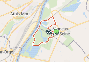
14.8 km | 17 km-effort
3h 52min
No
Trail Walking Montgeron - J 38 Montgeron la Pelouse, forêt de Sénart - Photo
Walking

Walking

Medium
(3)
Montgeron, Ile-de-France, Essonne, France
12.3 km | 13.2 km-effort
3h 9min
Yes
Trail Walking Soisy-sur-Seine - Sénart arbres remarquables 1/2 - Photo
Walking
dmatignon

Walking

Easy
(1)
Soisy-sur-Seine, Ile-de-France, Essonne, France
12.2 km | 13.1 km-effort
2h 55min
Yes
Trail Walking Draveil - Port aux Cerises - Ablon 21 km - Photo
Walking
GUIDE
jeanmarcMasson

Walking

Very difficult
(1)
Draveil, Ile-de-France, Essonne, France
22 km | 25 km-effort
4h 51min
Yes
Trail Walking Yerres - Boucle Yerres - Réveillon- Bois de la Grange - 12 km - Photo
Walking
GUIDE
jeanmarcMasson

Walking

Difficult
(1)
Yerres, Ile-de-France, Essonne, France
12.1 km | 14 km-effort
3h 11min
Yes
Trail Walking Yerres - Yerres - Montgeron - Brunoy 11,5 km - Photo
Walking
GUIDE
jeanmarcMasson

Walking

Difficult
(1)
Yerres, Ile-de-France, Essonne, France
11.2 km | 12.4 km-effort
2h 49min
Yes
Trail Walking Yerres - Bord de l'Yerres - Crosne - Bois de la Grange 10 km - Photo
Walking
GUIDE
jeanmarcMasson

Walking

Medium
(1)
Yerres, Ile-de-France, Essonne, France
9.6 km | 11 km-effort
2h 30min
Yes
Trail Walking Montgeron - 13767736-JVB 10 km - Photo
Walking
GUIDE
jeanmarcMasson

Walking

Medium
(1)
Montgeron, Ile-de-France, Essonne, France
10.3 km | 11.2 km-effort
2h 32min
Yes
Trail Walking Yerres - marathon RCY 2023 - Photo
Walking
chessyca

Walking

Very difficult
Yerres, Ile-de-France, Essonne, France
42 km | 47 km-effort
7h 59min
Yes


Close
My subscriptions