Trail Touring skiing Puy-Saint-André - rocher bouchard pente nord est  de crête de bressiere - Photo

rocher bouchard pente nord est de crête de bressiere

 tchoua
tchoua

User

© OpenStreetMap contributors
Length
Length
14.5 km
Max alt
Max alt
2575 m
Uphill gradient
Uphill gradient
970 m
Km-Effort
Km-Effort  
27 km
Min alt
Min alt
1597 m
Downhill gradient
Downhill gradient
929 m
Boucle
Boucle
No
Creation date :
2023-02-05 07:17:11.755
Updated on :
2023-02-05 14:42:49.458

(0 Reviews)

Touring skiing
Touring skiing
2h58
Difficulty : Difficult

Scan this QR Code to open this trail in the SityTrail application

FREE GPS app for hiking

Logo SityTrail SityTrail

IGN / Geographical institutes

Download SityTrail from the App Store Download SityTrail from Google Play

Logo SityTrail SityTrail World

The world is yours!

Download SityTrail from the App Store Download SityTrail from Google Play Download SityTrail on Huawei AppGallery

About

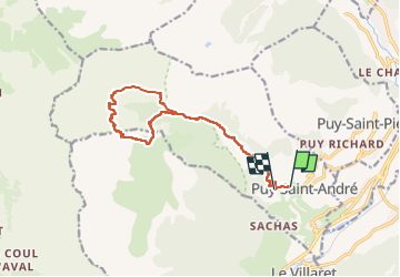
Trail Touring skiing of 14.5 km to be discovered at Provence-Alpes-Côte d'Azur, Hautes-Alpes, Puy-Saint-André. This trail is proposed by tchoua.

Description

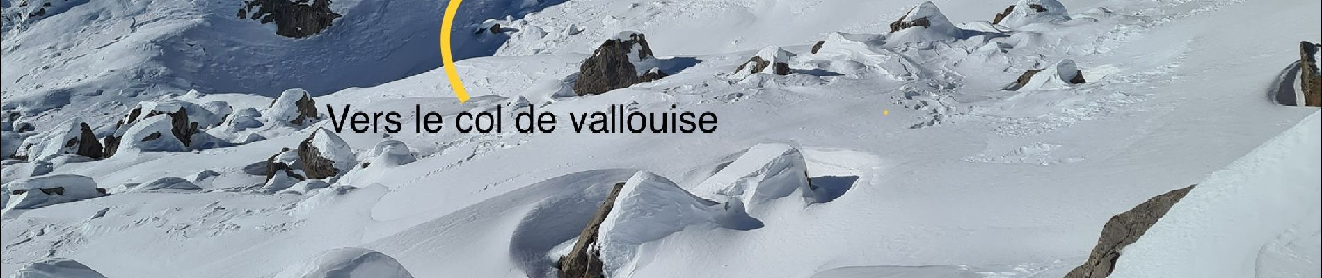
Pente nord est de crête de bressiere accès versant sud par le col de trancoulette

Elevation profile

Photos

Positioning

Country:
France
Region :
Provence-Alpes-Côte d'Azur
Department/Province :
Hautes-Alpes
Municipality :
Puy-Saint-André
Location:
Unknown
Start:(UTM)
309905 ; 4972324 (32T) N.

Trails nearby

Trail Walking Briançon - Briançon Schappe-3 têtes - Photo
Walking
Orcal37

Walking

Easy
(2)
Briançon, Provence-Alpes-Côte d'Azur, Hautes-Alpes, France
6.5 km | 11 km-effort
2h 5min
Yes
Trail Walking Saint-Chaffrey - le Prorel au départ de la Serre Chevalier - Photo
Walking
GUIDE
amiral13

Walking

Easy
Saint-Chaffrey, Provence-Alpes-Côte d'Azur, Hautes-Alpes, France
7.9 km | 13.8 km-effort
3h 41min
Yes
Trail Walking Puy-Saint-André - cime de la condamine - Photo
Walking
GUIDE
amiral13

Walking

Difficult
Puy-Saint-André, Provence-Alpes-Côte d'Azur, Hautes-Alpes, France
13.7 km | 28 km-effort
5h 59min
Yes
Trail Walking Briançon - Circuit: Fort des 3 Têtes et Fort Dauphin - Photo
Walking
GUIDE
lhomme.ph

Walking

Easy
(2)
Briançon, Provence-Alpes-Côte d'Azur, Hautes-Alpes, France
7.4 km | 11.9 km-effort
2h 40min
Yes
Trail Walking Briançon - Briancon: Fort des Trois tètes - Photo
Walking
GUIDE
lhomme.ph

Walking

Very easy
Briançon, Provence-Alpes-Côte d'Azur, Hautes-Alpes, France
5 km | 8.5 km-effort
2h 8min
Yes
Trail Walking Briançon - Briancon: Le tour du Fort des 3 Têtes   - Photo
Walking
GUIDE
lhomme.ph

Walking

Medium
(1)
Briançon, Provence-Alpes-Côte d'Azur, Hautes-Alpes, France
7.7 km | 12.7 km-effort
1h 50min
Yes
Trail Mountain bike Briançon - Montgenevre par route militaire - Photo
Mountain bike
Fred Aguesse

Mountain bike

Difficult
(1)
Briançon, Provence-Alpes-Côte d'Azur, Hautes-Alpes, France
36 km | 53 km-effort
3h 41min
No
Trail Trail Puy-Saint-André - Clos du Vas - Puy Chalvin - Photo
Trail
toutankhcarton

Trail

Medium
Puy-Saint-André, Provence-Alpes-Côte d'Azur, Hautes-Alpes, France
7.4 km | 13.4 km-effort
1h 30min
Yes
Trail Running Puy-Saint-André - Clos du Vas - St Blaise - Briançon - Villar St Pancrace (Hautes-Alpes) - Photo
Running
toutankhcarton

Running

Medium
Puy-Saint-André, Provence-Alpes-Côte d'Azur, Hautes-Alpes, France
8 km | 10 km-effort
1h 7min
Yes


Close
My subscriptions