Trail Nordic walking Vireux-Molhain - Circuit du Viroquois - Photo

Circuit du Viroquois

© OpenStreetMap contributors
Length
Length
6.1 km
Max alt
Max alt
166 m
Uphill gradient
Uphill gradient
115 m
Km-Effort
Km-Effort  
7.6 km
Min alt
Min alt
110 m
Downhill gradient
Downhill gradient
115 m
Boucle
Boucle
Yes
Creation date :
2023-02-08 13:16:23.431
Updated on :
2023-02-08 13:35:52.32

(0 Reviews)

Nordic walking
Nordic walking
1h41
Difficulty : Medium

Scan this QR Code to open this trail in the SityTrail application

FREE GPS app for hiking

Logo SityTrail SityTrail

IGN / Geographical institutes

Download SityTrail from the App Store Download SityTrail from Google Play

Logo SityTrail SityTrail World

The world is yours!

Download SityTrail from the App Store Download SityTrail from Google Play Download SityTrail on Huawei AppGallery

About

Trail Nordic walking of 6.1 km to be discovered at Grand Est, Ardennes, Vireux-Molhain. This trail is proposed by denissculier.

Description

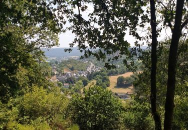
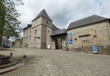
Découvrez les richesses du village de Vireux-Molhain : la Réserve Naturelle et son Mur des Douaniers, les rivières du Viroin et du Deluve serpentant au milieu de calmes pâturages, la collégiale, le Camp Romain et son point de vue…

Elevation profile

Positioning

Country:
France
Region :
Grand Est
Department/Province :
Ardennes
Municipality :
Vireux-Molhain
Location:
Unknown
Start:(UTM)
622309 ; 5549916 (31U) N.

Trails nearby

Trail Walking Viroinval - RB-Na-12 Ed4 Balade franco-belge chez Toine Culot - Photo
Walking
PRO

Walking

Medium
(2)
Viroinval, Wallonia, Namur, Belgium
14.8 km | 21 km-effort
6h 13min
Yes
Trail Walking Viroinval - Mazée, sur le sentier des Douaniers - Photo
Walking
GUIDE
Desrumaux

Walking

Very easy
(1)
Viroinval, Wallonia, Namur, Belgium
7.6 km | 10.5 km-effort
4h 2min
Yes
Trail Walking Vireux-Molhain - Balade Franco-Belge - De Vireux-Molhain à Mazée - Photo
Walking
tracegps

Walking

Medium
(1)
Vireux-Molhain, Grand Est, Ardennes, France
14.4 km | 19.2 km-effort
3h 30min
Yes
Trail Walking Vireux-Molhain - Du Mont Vireux au château de Hierges - Photo
Walking
tracegps

Walking

Difficult
(1)
Vireux-Molhain, Grand Est, Ardennes, France
12.3 km | 16.8 km-effort
4h 0min
Yes
Trail Walking Vireux-Molhain - Du Mont Vireux au château de Hierges - Photo
Walking
GUIDE
Desrumaux

Walking

Easy
(1)
Vireux-Molhain, Grand Est, Ardennes, France
12.3 km | 16.8 km-effort
3h 0min
Yes
Trail Walking Doische - Enregistré le 1 mars 2023 10:37:39 - Photo
Walking
GUIDE
Desrumaux

Walking

Medium
Doische, Wallonia, Namur, Belgium
6.7 km | 8.7 km-effort
1h 58min
Yes
Trail On foot Viroinval - La Villa Gallo-Romaine - Photo
On foot
PRO

On foot

Easy
Viroinval, Wallonia, Namur, Belgium
3.7 km | 4.5 km-effort
1h 1min
Yes
Trail On foot Viroinval - Pré Aigret - Photo
On foot
PRO

On foot

Easy
Viroinval, Wallonia, Namur, Belgium
7.7 km | 10.8 km-effort
2h 26min
Yes
Trail On foot Viroinval - Les Rivelottes - Photo
On foot
PRO

On foot

Easy
Viroinval, Wallonia, Namur, Belgium
3.6 km | 4.8 km-effort
1h 5min
Yes


Close
My subscriptions