Trail Walking Montagrier - 2023-03-10_16h37m21_joyeux-randonneurs-a-montagrier-2 - Photo

2023-03-10_16h37m21_joyeux-randonneurs-a-montagrier-2

 swp648
swp648

User

© OpenStreetMap contributors
Length
Length
10.7 km
Max alt
Max alt
205 m
Uphill gradient
Uphill gradient
284 m
Km-Effort
Km-Effort  
14.5 km
Min alt
Min alt
120 m
Downhill gradient
Downhill gradient
283 m
Boucle
Boucle
Yes
Creation date :
2023-03-10 15:37:22.489
Updated on :
2023-03-10 15:40:33.085

(1 Reviews)

Walking
Walking
3h18
Difficulty : Difficult

Scan this QR Code to open this trail in the SityTrail application

FREE GPS app for hiking

Logo SityTrail SityTrail

IGN / Geographical institutes

Download SityTrail from the App Store Download SityTrail from Google Play

Logo SityTrail SityTrail World

The world is yours!

Download SityTrail from the App Store Download SityTrail from Google Play Download SityTrail on Huawei AppGallery

About

Trail Walking of 10.7 km to be discovered at New Aquitaine, Dordogne, Montagrier. This trail is proposed by swp648.

Description

Randonnée accessible à tous. Il existe pratiquement toujours des possibilités  pour raccourcir le circuit à environ  6km.

Elevation profile

Positioning

Country:
France
Region :
New Aquitaine
Department/Province :
Dordogne
Municipality :
Montagrier
Location:
Unknown
Start:(Dec)
Start:(UTM)
302258 ; 5015860 (31T) N.

Comments

Please log in to post a review or rate the element


Trails nearby

Trail Walking Saint-Victor - 24 Boucle de Saint-Victor  - Photo
Walking
Patxito

Walking

Easy
(1)
Saint-Victor, New Aquitaine, Dordogne, France
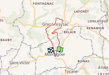
11.7 km | 16.1 km-effort
3h 24min
Yes
Trail Walking Grand-Brassac - Mardi 06-06-2023 Grand Brassac via Montagrier - Photo
Walking
CASAURANCQ

Walking

Difficult
Grand-Brassac, New Aquitaine, Dordogne, France
10.1 km | 13.8 km-effort
3h 7min
Yes
Trail Walking Montagrier - montagrier - Photo
Walking
ANNIEXAVE

Walking

Medium
Montagrier, New Aquitaine, Dordogne, France
10.5 km | 14.2 km-effort
2h 33min
Yes
Trail Walking Tocane-Saint-Apre - Tocane Sud-Est - Photo
Walking
swp648

Walking

Very easy
Tocane-Saint-Apre, New Aquitaine, Dordogne, France
12.4 km | 14.6 km-effort
3h 11min
Yes
Trail Walking Saint-Méard-de-Drône - boucle saint meard sur dronne - Photo
Walking
fab0202

Walking

Easy
Saint-Méard-de-Drône, New Aquitaine, Dordogne, France
10.5 km | 13.5 km-effort
2h 38min
Yes
Trail Walking Saint-Méard-de-Drône - St Méard de Drône - Photo
Walking
swp648

Walking

Very easy
Saint-Méard-de-Drône, New Aquitaine, Dordogne, France
10.6 km | 13.5 km-effort
2h 55min
Yes
Trail Walking Grand-Brassac - grand brassac - Photo
Walking
descardm

Walking

Difficult
Grand-Brassac, New Aquitaine, Dordogne, France
10.6 km | 14.2 km-effort
2h 36min
Yes
Trail Walking Douchapt - boucle des fontaines - Photo
Walking
descardm

Walking

Difficult
Douchapt, New Aquitaine, Dordogne, France
10.6 km | 13.7 km-effort
2h 54min
Yes
Trail Walking Tocane-Saint-Apre - boucle de Tocane - Photo
Walking
ANNIEXAVE

Walking

Easy
Tocane-Saint-Apre, New Aquitaine, Dordogne, France
8.4 km | 9.8 km-effort
2h 0min
Yes


Close
My subscriptions