Trail Walking Saint-Victor - 24 Boucle de Saint-Victor  - Photo

24 Boucle de Saint-Victor

 Patxito
Patxito

User

© OpenStreetMap contributors
Length
Length
11.7 km
Max alt
Max alt
176 m
Uphill gradient
Uphill gradient
332 m
Km-Effort
Km-Effort  
16.1 km
Min alt
Min alt
72 m
Downhill gradient
Downhill gradient
332 m
Boucle
Boucle
Yes
Creation date :
2017-04-17 00:00:00.0
Updated on :
2017-04-17 00:00:00.0

(1 Reviews)

Walking
Walking
3h24
Difficulty : Easy

Scan this QR Code to open this trail in the SityTrail application

FREE GPS app for hiking

Logo SityTrail SityTrail

IGN / Geographical institutes

Download SityTrail from the App Store Download SityTrail from Google Play

Logo SityTrail SityTrail World

The world is yours!

Download SityTrail from the App Store Download SityTrail from Google Play Download SityTrail on Huawei AppGallery

About

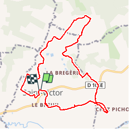
Trail Walking of 11.7 km to be discovered at New Aquitaine, Dordogne, Saint-Victor. This trail is proposed by Patxito.

Elevation profile

Photos

Points of interest

Point of interest Saint-Victor - Point 1 - Photo
Patxito
SAINT-VICTOR 
Point of interest Saint-Victor - Point 3 - Photo
Patxito
SAINT-VICTOR 
Point of interest Saint-Méard-de-Drône - Point 4 - Photo
Patxito
SAINT-MÉARD-DE-DRÔNE 
Point of interest Saint-Victor - Point 5 - Photo
Patxito
SAINT-VICTOR 
Point of interest Montagrier - Point 6 - Photo
Patxito
MONTAGRIER 
Point of interest Saint-Victor - Point 7 - Photo
Patxito
SAINT-VICTOR 
Point of interest Grand-Brassac - Point 8 - Photo
Patxito
GRAND-BRASSAC 
Point of interest Saint-Victor - Point 10 - Photo
Patxito
SAINT-VICTOR 
Point of interest Saint-Victor - Point 11 - Photo
Patxito
SAINT-VICTOR 
Point of interest Montagrier - Point 12 - Photo
Patxito
MONTAGRIER 
Point of interest Saint-Victor - Point 13 - Photo
Patxito
SAINT-VICTOR 
Point of interest Montagrier - Point 15 - Photo
Patxito
MONTAGRIER 
Point of interest Montagrier - Point 16 - Photo
Patxito
MONTAGRIER 
Point of interest Saint-Victor - Point 19 - Photo
Patxito
SAINT-VICTOR 

Positioning

Country:
France
Region :
New Aquitaine
Department/Province :
Dordogne
Municipality :
Saint-Victor
Location:
Unknown
Start:(UTM)
298971 ; 5015461 (31T) N.

Comments

Please log in to post a review or rate the element


Trails nearby

Trail Walking Celles - Boucle de Celles - Photo
Walking
swp648

Walking

Easy
Celles, New Aquitaine, Dordogne, France
12.8 km | 16.4 km-effort
3h 10min
Yes
Trail Walking Celles - boucle celles - Photo
Walking
fab0202

Walking

Easy
Celles, New Aquitaine, Dordogne, France
13 km | 16.7 km-effort
3h 6min
Yes
Trail Walking Celles - 24 Celles  - Photo
Walking
Patxito

Walking

Easy
Celles, New Aquitaine, Dordogne, France
13.2 km | 16.8 km-effort
3h 34min
Yes
Trail Walking Grand-Brassac - Mardi 06-06-2023 Grand Brassac via Montagrier - Photo
Walking
CASAURANCQ

Walking

Difficult
Grand-Brassac, New Aquitaine, Dordogne, France
10.1 km | 13.8 km-effort
3h 7min
Yes
Trail Walking Montagrier - 2023-03-10_16h37m21_joyeux-randonneurs-a-montagrier-2 - Photo
Walking
swp648

Walking

Difficult
(1)
Montagrier, New Aquitaine, Dordogne, France
10.7 km | 14.5 km-effort
3h 18min
Yes
Trail Walking Montagrier - montagrier - Photo
Walking
ANNIEXAVE

Walking

Medium
Montagrier, New Aquitaine, Dordogne, France
10.5 km | 14.2 km-effort
2h 33min
Yes
Trail Walking Tocane-Saint-Apre - Tocane Sud-Est - Photo
Walking
swp648

Walking

Very easy
Tocane-Saint-Apre, New Aquitaine, Dordogne, France
12.4 km | 14.6 km-effort
3h 11min
Yes
Trail Walking Saint-Méard-de-Drône - boucle saint meard sur dronne - Photo
Walking
fab0202

Walking

Easy
Saint-Méard-de-Drône, New Aquitaine, Dordogne, France
10.5 km | 13.5 km-effort
2h 38min
Yes
Trail Walking Saint-Méard-de-Drône - St Méard de Drône - Photo
Walking
swp648

Walking

Very easy
Saint-Méard-de-Drône, New Aquitaine, Dordogne, France
10.6 km | 13.5 km-effort
2h 55min
Yes


Close
My subscriptions