Trail Walking Lugon-et-l'Île-du-Carnay - langon - Photo
 turbo33
turbo33

User

© OpenStreetMap contributors
Length
Length
13.4 km
Max alt
Max alt
77 m
Uphill gradient
Uphill gradient
159 m
Km-Effort
Km-Effort  
15.5 km
Min alt
Min alt
6 m
Downhill gradient
Downhill gradient
157 m
Boucle
Boucle
Yes
Creation date :
2023-03-30 06:18:11.26
Updated on :
2023-03-30 09:30:32.604

(0 Reviews)

Walking
Walking
2h58
Difficulty : Medium

Scan this QR Code to open this trail in the SityTrail application

FREE GPS app for hiking

Logo SityTrail SityTrail

IGN / Geographical institutes

Download SityTrail from the App Store Download SityTrail from Google Play

Logo SityTrail SityTrail World

The world is yours!

Download SityTrail from the App Store Download SityTrail from Google Play Download SityTrail on Huawei AppGallery

About

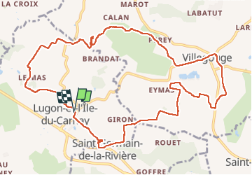
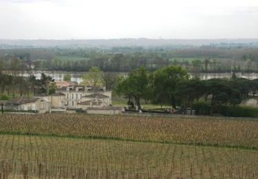
Trail Walking of 13.4 km to be discovered at New Aquitaine, Gironde, Lugon-et-l'Île-du-Carnay. This trail is proposed by turbo33.

Elevation profile

Positioning

Country:
France
Region :
New Aquitaine
Department/Province :
Gironde
Municipality :
Lugon-et-l'Île-du-Carnay
Location:
Unknown
Start:(UTM)
709712 ; 4981657 (30T) N.

Trails nearby

Trail Walking Saint-Romain-la-Virvée - Asques - Photo
Walking
bedous

Walking

Difficult
Saint-Romain-la-Virvée, New Aquitaine, Gironde, France
13.5 km | 16.1 km-effort
3h 39min
Yes
Trail Walking Saint-Germain-de-la-Rivière - St Germain  la rivière  9 4 2024 - Photo
Walking
gerardbarreau

Walking

Difficult
Saint-Germain-de-la-Rivière, New Aquitaine, Gironde, France
11 km | 13.4 km-effort
3h 2min
Yes
Trail Walking Saint-Michel-de-Fronsac -  Saint-Michel de fronsac - Photo
Walking
clbolb7

Walking

Very easy
Saint-Michel-de-Fronsac, New Aquitaine, Gironde, France
6.4 km | 8.4 km-effort
2h 46min
Yes
Trail Running Saint-Michel-de-Fronsac - Trail à Saint Michel de Fronsac - Photo
Running
tracegps

Running

Difficult
Saint-Michel-de-Fronsac, New Aquitaine, Gironde, France
34 km | 46 km-effort
5h 0min
Yes
Trail Mountain bike Vérac - Fronsadais - De Vérac à Fronsac - Photo
Mountain bike
tracegps

Mountain bike

Medium
Vérac, New Aquitaine, Gironde, France
40 km | 48 km-effort
3h 0min
Yes
Trail Walking Vérac - Fronsadais - De Vérac à Fronsac - Photo
Walking
tracegps

Walking

Difficult
Vérac, New Aquitaine, Gironde, France
40 km | 48 km-effort
8h 0min
Yes
Trail Walking Saint-Romain-la-Virvée - Saint Romain de Virvee - Photo
Walking
20LTh

Walking

Medium
Saint-Romain-la-Virvée, New Aquitaine, Gironde, France
12.3 km | 13.8 km-effort
3h 24min
Yes
Trail Walking Saint-Germain-de-la-Rivière - St Germain la Rivière  - Photo
Walking
plavengut

Walking

Medium
Saint-Germain-de-la-Rivière, New Aquitaine, Gironde, France
12.5 km | 15.1 km-effort
3h 30min
Yes
Trail Walking Tarnès - Tarnés - Photo
Walking
JACQUOU

Walking

Medium
Tarnès, New Aquitaine, Gironde, France
22 km | 25 km-effort
5h 44min
Yes


Close
My subscriptions