Trail Walking Voreppe - Aiguille de Chalais - Photo
 flip38
flip38

User

© OpenStreetMap contributors
Length
Length
17.5 km
Max alt
Max alt
1076 m
Uphill gradient
Uphill gradient
1168 m
Km-Effort
Km-Effort  
33 km
Min alt
Min alt
199 m
Downhill gradient
Downhill gradient
1169 m
Boucle
Boucle
Yes
Creation date :
2023-04-23 07:43:08.685
Updated on :
2023-04-24 17:10:06.575

(0 Reviews)

Walking
Walking
5h31
Difficulty : Difficult

Scan this QR Code to open this trail in the SityTrail application

FREE GPS app for hiking

Logo SityTrail SityTrail

IGN / Geographical institutes

Download SityTrail from the App Store Download SityTrail from Google Play

Logo SityTrail SityTrail World

The world is yours!

Download SityTrail from the App Store Download SityTrail from Google Play Download SityTrail on Huawei AppGallery

About

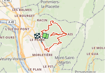
Trail Walking of 17.5 km to be discovered at Auvergne-Rhône-Alpes, Isère, Voreppe. This trail is proposed by flip38.

Description

Belle boucle mais exigeante vers ce joli petit sommet de Chartreuse : l'Aiguille de Chalais (1089m).
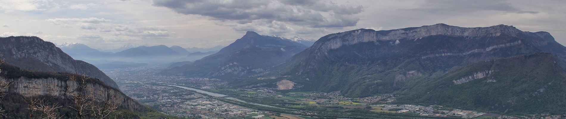
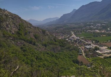
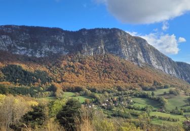
Principalement en forêt, vous bénéficierez de quelques jolis belvédères sur la vallée au dessus de Voreppe.
A noter : n'hésitez pas à visiter la boutique du monastère, vous y trouverez de bons produits, dont les fameux et excellents biscuits de Chalais fabriqués sur place par les sœurs.

Elevation profile

Photos

Positioning

Country:
France
Region :
Auvergne-Rhône-Alpes
Department/Province :
Isère
Municipality :
Voreppe
Location:
Unknown
Start:(UTM)
707578 ; 5018098 (31T) N.

Trails nearby

Trail Walking Voreppe - Le Rocher de Lorzier, 1838m - Photo
Walking
tracegps

Walking

Medium
(2)
Voreppe, Auvergne-Rhône-Alpes, Isère, France
12.3 km | 25 km-effort
4h 45min
Yes
Trail Electric bike Voreppe - voreppe saint julien le grand raz voreppe - Photo
Electric bike
gaille38

Electric bike

Difficult
(1)
Voreppe, Auvergne-Rhône-Alpes, Isère, France
35 km | 50 km-effort
Unknown
Yes
Trail Walking Proveysieux - le rocher de l'Eglise en traversee - Photo
Walking
cmarit

Walking

Difficult
(1)
Proveysieux, Auvergne-Rhône-Alpes, Isère, France
10.5 km | 22 km-effort
8h 16min
Yes
Trail Walking Voreppe - le trou au loup  - Photo
Walking
cousam

Walking

Difficult
Voreppe, Auvergne-Rhône-Alpes, Isère, France
8.5 km | 16.5 km-effort
6h 29min
Yes
Trail Walking Voreppe - 38 voreppe - Photo
Walking
himba26100

Walking

Medium
Voreppe, Auvergne-Rhône-Alpes, Isère, France
8.7 km | 16.8 km-effort
6h 25min
Yes
Trail Walking Mont-Saint-Martin - la Meulière des Dauphins par Mont St Martin - Photo
Walking
Ak38

Walking

Medium
Mont-Saint-Martin, Auvergne-Rhône-Alpes, Isère, France
6.3 km | 11.1 km-effort
1h 52min
Yes
Trail Walking Mont-Saint-Martin - 111123 - Photo
Walking
mzonzon05

Walking

Medium
Mont-Saint-Martin, Auvergne-Rhône-Alpes, Isère, France
4.2 km | 9.3 km-effort
1h 54min
Yes
Trail Walking Voreppe - vire de l'aiguille de Chalais  - Photo
Walking
cmarit

Walking

Difficult
Voreppe, Auvergne-Rhône-Alpes, Isère, France
3.4 km | 6.8 km-effort
6h 26min
No
Trail Walking La Buisse - Le trou noir de la buisse - Photo
Walking
cmarit

Walking

Difficult
La Buisse, Auvergne-Rhône-Alpes, Isère, France
4.1 km | 5.9 km-effort
5h 38min
Yes


Close
My subscriptions