


hohneck

adubarry
User
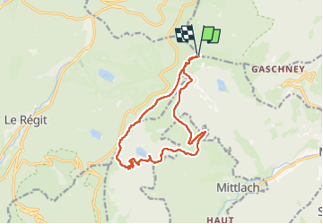

Length
14 km

Max alt
1355 m

Uphill gradient
591 m
Km-Effort
22 km

Min alt
921 m

Downhill gradient
588 m
Boucle
Yes
Creation date :
2023-04-29 08:58:44.932
Updated on :
2023-04-29 16:43:51.006
4h57
Difficulty : Very difficult

FREE GPS app for hiking
 SityTrail
IGN / Geographical institutes
SityTrail Plus
The world is yours!
About
Trail Walking of 14 km to be discovered at Grand Est, Haut-Rhin, Stosswihr. This trail is proposed by adubarry.
Positioning
Country:
France
Region :
Grand Est
Department/Province :
Haut-Rhin
Municipality :
Stosswihr
Location:
Unknown
Start:(Dec)
Start:(UTM)
352122 ; 5322414 (32U) N.
Comments