Trail Walking Échalas - échalas teel - Photo
 6ARVAL7
6ARVAL7

User

© OpenStreetMap contributors
Length
Length
10.8 km
Max alt
Max alt
478 m
Uphill gradient
Uphill gradient
229 m
Km-Effort
Km-Effort  
13.9 km
Min alt
Min alt
281 m
Downhill gradient
Downhill gradient
230 m
Boucle
Boucle
Yes
Creation date :
2023-05-10 12:08:08.407
Updated on :
2023-05-10 15:33:45.211

(0 Reviews)

Walking
Walking
2h46
Difficulty : Easy

Scan this QR Code to open this trail in the SityTrail application

FREE GPS app for hiking

Logo SityTrail SityTrail

IGN / Geographical institutes

Download SityTrail from the App Store Download SityTrail from Google Play

Logo SityTrail SityTrail World

The world is yours!

Download SityTrail from the App Store Download SityTrail from Google Play Download SityTrail on Huawei AppGallery

About

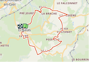
Trail Walking of 10.8 km to be discovered at Auvergne-Rhône-Alpes, Rhône, Échalas. This trail is proposed by 6ARVAL7.

Description

un peu de route mais de jolis passages et de beaux panoramas

Elevation profile

Positioning

Country:
France
Region :
Auvergne-Rhône-Alpes
Department/Province :
Rhône
Municipality :
Échalas
Location:
Unknown
Start:(UTM)
633907 ; 5045675 (31T) N.

Trails nearby

Trail Walking Trèves - Chemin de Fer à Trèves - Photo
Walking
tracegps

Walking

Medium
(1)
Trèves, Auvergne-Rhône-Alpes, Rhône, France
4.5 km | 6.8 km-effort
1h 30min
Yes
Trail Walking Échalas - 69-echalas-17km-450m - Photo
Walking
SyMA

Walking

Difficult
Échalas, Auvergne-Rhône-Alpes, Rhône, France
17.4 km | 23 km-effort
5h 17min
Yes
Trail Walking Échalas - Rando à Echalas - Photo
Walking
tracegps

Walking

Medium
(1)
Échalas, Auvergne-Rhône-Alpes, Rhône, France
21 km | 29 km-effort
5h 0min
Yes
Trail Walking Trèves - Randonnée de Trèves à Dizimieux - Photo
Walking
tracegps

Walking

Medium
Trèves, Auvergne-Rhône-Alpes, Rhône, France
7.2 km | 10.3 km-effort
2h 0min
Yes
Trail Walking Mornant - Bellevue - Photo
Walking
Zebulon699

Walking

Medium
Mornant, Auvergne-Rhône-Alpes, Rhône, France
7.9 km | 9.4 km-effort
2h 16min
Yes
Trail Walking Échalas - cx régis reco 01 08 23 - 8km a 218 g0.5  - Photo
Walking
jtraverse

Walking

Medium
Échalas, Auvergne-Rhône-Alpes, Rhône, France
7.9 km | 10.8 km-effort
2h 43min
Yes
Trail Walking Beauvallon - toulas 8.8 - Photo
Walking
cacrhone

Walking

Medium
(1)
Beauvallon, Auvergne-Rhône-Alpes, Rhône, France
8.4 km | 10 km-effort
2h 54min
No
Trail Walking Trèves - 2022 07 17 - Photo
Walking
lr80

Walking

Medium
Trèves, Auvergne-Rhône-Alpes, Rhône, France
15.3 km | 22 km-effort
3h 0min
Yes
Trail Walking Les Haies - Croix Régis - circuit du Croizat - 9,7 km - 272 m de dénivelé - 3h - Photo
Walking
Clubléorando

Walking

Easy
Les Haies, Auvergne-Rhône-Alpes, Rhône, France
9.7 km | 13.3 km-effort
3h 0min
Yes


Close
My subscriptions