Trail Walking Céret - roure - Photo
© OpenStreetMap contributors
Length
Length
16.5 km
Max alt
Max alt
420 m
Uphill gradient
Uphill gradient
578 m
Km-Effort
Km-Effort  
24 km
Min alt
Min alt
142 m
Downhill gradient
Downhill gradient
576 m
Boucle
Boucle
Yes
Creation date :
2014-12-10 00:00:00.0
Updated on :
2014-12-10 00:00:00.0

(0 Reviews)

Walking
Walking
5h05
Difficulty : Medium

Scan this QR Code to open this trail in the SityTrail application

FREE GPS app for hiking

Logo SityTrail SityTrail

IGN / Geographical institutes

Download SityTrail from the App Store Download SityTrail from Google Play

Logo SityTrail SityTrail World

The world is yours!

Download SityTrail from the App Store Download SityTrail from Google Play Download SityTrail on Huawei AppGallery

About

Trail Walking of 16.5 km to be discovered at Occitania, Pyrénées-Orientales, Céret. This trail is proposed by rosemarie.

Description

pont de ceret- chapelle st paul - ND Roure - retur par Reuros

Elevation profile

Points of interest

Point of interest Céret - 010 - Photo
rosemarie
CÉRET 
Point of interest Céret - 009 - Photo
rosemarie
CÉRET 
Point of interest Taillet - 006 - Photo
rosemarie
TAILLET 

Positioning

Country:
France
Region :
Occitania
Department/Province :
Pyrénées-Orientales
Municipality :
Céret
Location:
Unknown
Start:(UTM)
478982 ; 4704921 (31T) N.

Trails nearby

Trail Walking Vivès - Le sentier de Vinés - Photo
Walking
bernarb

Walking

Easy
(2)
Vivès, Occitania, Pyrénées-Orientales, France
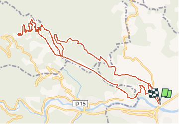
9.9 km | 13 km-effort
2h 54min
Yes
Trail Walking Saint-Jean-Pla-de-Corts - 66 ST-JEAN-PLA-DE-CORTS, promenade autour du Tech, jusqu'au BOULOU  - Photo
Walking
jeff66

Walking

Easy
(1)
Saint-Jean-Pla-de-Corts, Occitania, Pyrénées-Orientales, France
7.9 km | 8.8 km-effort
1h 18min
Yes
Trail Walking Maureillas-las-Illas - CERET 66 - les hauts de CERET - ballade en bas Vallespir - dolmen de la Siureda torre Bel Ull  - Photo
Walking
jeff66

Walking

Medium
(1)
Maureillas-las-Illas, Occitania, Pyrénées-Orientales, France
6.5 km | 9.9 km-effort
1h 24min
Yes
Trail Walking Vivès - Vives llauro  - Photo
Walking
GUIDE
antignacs

Walking

Very easy
Vivès, Occitania, Pyrénées-Orientales, France
8.2 km | 11.7 km-effort
2h 15min
Yes
Trail Walking Céret - Ermitage de saint ferreol - Photo
Walking
philippe66

Walking

Medium
(1)
Céret, Occitania, Pyrénées-Orientales, France
7.6 km | 10.4 km-effort
1h 59min
Yes
Trail Walking Céret - blacon de ceret via la cascade - Photo
Walking
philippe66

Walking

Medium
(3)
Céret, Occitania, Pyrénées-Orientales, France
10.1 km | 14.4 km-effort
3h 9min
Yes
Trail Walking Saint-Jean-Pla-de-Corts - st jean St fereol - Photo
Walking
66Gribouille83

Walking

Difficult
Saint-Jean-Pla-de-Corts, Occitania, Pyrénées-Orientales, France
13.5 km | 17.6 km-effort
6h 44min
Yes
Trail Walking Maureillas-las-Illas - Maureillas  - Photo
Walking
francineposkin

Walking

Difficult
Maureillas-las-Illas, Occitania, Pyrénées-Orientales, France
12.8 km | 16.9 km-effort
4h 34min
No
Trail Other activity Reynès - Reynes mine de talc+ cascade - Photo
Other activity
robertperello

Other activity

Difficult
(1)
Reynès, Occitania, Pyrénées-Orientales, France
8.5 km | 14.4 km-effort
2h 50min
Yes


Close
My subscriptions