


tour du gashney

claudel
User
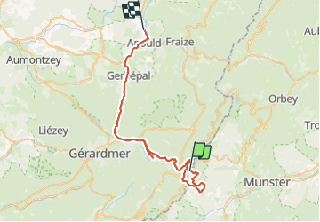

Length
45 km

Max alt
1355 m

Uphill gradient
819 m
Km-Effort
58 km

Min alt
439 m

Downhill gradient
1610 m
Boucle
No
Creation date :
2023-06-09 06:48:02.075
Updated on :
2023-06-10 09:18:41.155
3h47
Difficulty : Very difficult

FREE GPS app for hiking
 SityTrail
IGN / Geographical institutes
SityTrail Plus
The world is yours!
About
Trail Walking of 45 km to be discovered at Grand Est, Haut-Rhin, Stosswihr. This trail is proposed by claudel.
Positioning
Country:
France
Region :
Grand Est
Department/Province :
Haut-Rhin
Municipality :
Stosswihr
Location:
Unknown
Start:(Dec)
Start:(UTM)
352259 ; 5323953 (32U) N.
Comments