Trail Walking Mont-Saint-Jean - 1= Mont St Jean ~ Sillé le Guillaume - Photo

1= Mont St Jean ~ Sillé le Guillaume

© OpenStreetMap contributors
Length
Length
9.1 km
Max alt
Max alt
247 m
Uphill gradient
Uphill gradient
206 m
Km-Effort
Km-Effort  
11.7 km
Min alt
Min alt
149 m
Downhill gradient
Downhill gradient
165 m
Boucle
Boucle
No
Creation date :
2023-06-26 11:10:21.603
Updated on :
2023-06-30 17:47:30.279

(0 Reviews)

Walking
Walking
1h52
Difficulty : Very easy

Scan this QR Code to open this trail in the SityTrail application

FREE GPS app for hiking

Logo SityTrail SityTrail

IGN / Geographical institutes

Download SityTrail from the App Store Download SityTrail from Google Play

Logo SityTrail SityTrail World

The world is yours!

Download SityTrail from the App Store Download SityTrail from Google Play Download SityTrail on Huawei AppGallery

About

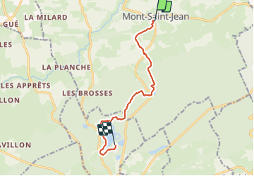
Trail Walking of 9.1 km to be discovered at Pays de la Loire, Sarthe, Mont-Saint-Jean. This trail is proposed by meunier.ph..

Description

Départ de l'étape 1 de mon tour des Alpes Mancelles = Mont St Jean à Sillé le Guillaume.

Elevation profile

Photos

Positioning

Country:
France
Region :
Pays de la Loire
Department/Province :
Sarthe
Municipality :
Mont-Saint-Jean
Location:
Unknown
Start:(UTM)
714775 ; 5347625 (30U) N.

Trails nearby

Trail On foot Sillé-le-Guillaume - Tour du Grand Étang - Photo
On foot
PRO

On foot

Easy
Sillé-le-Guillaume, Pays de la Loire, Sarthe, France
3.8 km | 4.4 km-effort
1h 0min
Yes
Trail Walking Sillé-le-Guillaume - adal_stesuzanne 20160530 m - Photo
Walking
VVerley

Walking

Medium
(1)
Sillé-le-Guillaume, Pays de la Loire, Sarthe, France
14.1 km | 17.1 km-effort
3h 42min
Yes
Trail Walking Sillé-le-Guillaume - 2 = Sillé le Guillaume - Fresnay sur Sarthe  - Photo
Walking
meunier.ph.

Walking

Easy
Sillé-le-Guillaume, Pays de la Loire, Sarthe, France
28 km | 34 km-effort
5h 50min
No
Trail On foot Saint-Germain-de-Coulamer - Sentier de Bel Air (a) - Photo
On foot
PRO

On foot

Easy
Saint-Germain-de-Coulamer, Pays de la Loire, Mayenne, France
6.5 km | 8 km-effort
1h 49min
Yes
Trail On foot Saint-Germain-de-Coulamer - Sentier de Bel Air - Photo
On foot
PRO

On foot

Easy
Saint-Germain-de-Coulamer, Pays de la Loire, Mayenne, France
10.6 km | 13.2 km-effort
3h 0min
Yes
Trail On foot Saint-Georges-le-Gaultier - La Croix aux Coquillages - Photo
On foot
PRO

On foot

Easy
Saint-Georges-le-Gaultier, Pays de la Loire, Sarthe, France
7.5 km | 9.5 km-effort
2h 9min
Yes
Trail Mountain bike Sillé-le-Guillaume - Autour du lac de Sillé le Guillaume - Photo
Mountain bike
tracegps

Mountain bike

Difficult
Sillé-le-Guillaume, Pays de la Loire, Sarthe, France
33 km | 41 km-effort
3h 0min
Yes
Trail Mountain bike Sillé-le-Guillaume - Autour de Sillé le Guillaume - Photo
Mountain bike
tracegps

Mountain bike

Difficult
Sillé-le-Guillaume, Pays de la Loire, Sarthe, France
43 km | 51 km-effort
4h 0min
Yes
Trail Walking Mont-Saint-Jean - Tour des Alpes Mancelles en 4 jours - Photo
Walking
meunier.ph.

Walking

Easy
Mont-Saint-Jean, Pays de la Loire, Sarthe, France
87 km | 108 km-effort
17h 0min
Yes


Close
My subscriptions