Trail Walking Xonrupt-Longemer - Tour des lacs de Longemer et Retournemer et cascades - Photo

Tour des lacs de Longemer et Retournemer et cascades

 mdieu
mdieu

User

© OpenStreetMap contributors
Length
Length
12.3 km
Max alt
Max alt
847 m
Uphill gradient
Uphill gradient
259 m
Km-Effort
Km-Effort  
15.8 km
Min alt
Min alt
732 m
Downhill gradient
Downhill gradient
258 m
Boucle
Boucle
Yes
Creation date :
2023-07-25 08:33:27.769
Updated on :
2023-07-27 06:39:06.684

(1 Reviews)

Walking
Walking
2h57
Difficulty : Easy

Scan this QR Code to open this trail in the SityTrail application

FREE GPS app for hiking

Logo SityTrail SityTrail

IGN / Geographical institutes

Download SityTrail from the App Store Download SityTrail from Google Play

Logo SityTrail SityTrail World

The world is yours!

Download SityTrail from the App Store Download SityTrail from Google Play Download SityTrail on Huawei AppGallery

About

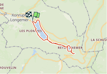
Trail Walking of 12.3 km to be discovered at Grand Est, Vosges, Xonrupt-Longemer. This trail is proposed by mdieu.

Description

Promenade familiale autour des 2 lacs et visite des  cascades dont celle de Charlemagne. Plusieurs points de restauration. Nous avons privilégié un retour du lac de Retournemer par le même GR de pays que pour l'aller afin d'éviter le danger de la route. une partie suit la départementale au retour de Longemer mais le trajet est bien protégé et peu de circulation.  La balade Peut-être réalisée beaucoup plus rapidement que le temps indiqué.

Elevation profile

Photos

Positioning

Country:
France
Region :
Grand Est
Department/Province :
Vosges
Municipality :
Xonrupt-Longemer
Location:
Unknown
Start:(UTM)
346693 ; 5327010 (32U) N.

Comments

Please log in to post a review or rate the element


Trails nearby

Trail Walking La Bresse - Lac de Lispach et sentier Dielaine  - Photo
Walking
zazie

Walking

Medium
(1)
La Bresse, Grand Est, Vosges, France
9.7 km | 14.9 km-effort
2h 30min
Yes
Trail Walking La Bresse - Les 5 lacs autour du Hohneck - Photo
Walking
tiene

Walking

Very difficult
(1)
La Bresse, Grand Est, Vosges, France
21 km | 36 km-effort
7h 21min
Yes
Trail Walking La Bresse - lac de Lispach - Photo
Walking
fedinois1

Walking

Easy
(1)
La Bresse, Grand Est, Vosges, France
10.4 km | 14.1 km-effort
4h 6min
Yes
Trail Walking La Bresse - lac de Lispach - Photo
Walking
fedinois1

Walking

Easy
(3)
La Bresse, Grand Est, Vosges, France
10.4 km | 14.1 km-effort
4h 6min
Yes
Trail Walking Ban-sur-Meurthe-Clefcy - La vallée de Belbriette - Ban-sur-Meurthe-Clefcy - Photo
Walking
tracegps

Walking

Medium
(2)
Ban-sur-Meurthe-Clefcy, Grand Est, Vosges, France
9.8 km | 12.6 km-effort
2h 30min
Yes
Trail Walking Gérardmer - gerardmer - la mauselaine . tête grauvelin . Roche boquet . croix claudé . hautes Vannes . la mauselaine  - Photo
Walking
stef789

Walking

Very easy
(1)
Gérardmer, Grand Est, Vosges, France
11.3 km | 16.2 km-effort
3h 42min
Yes
Trail Walking Xonrupt-Longemer - 23-08-17 Lac Longemer - Lispach - Photo
Walking
annefrance70

Walking

Medium
(1)
Xonrupt-Longemer, Grand Est, Vosges, France
7 km | 12.1 km-effort
2h 13min
Yes
Trail Walking La Bresse - Lac de Lispach  - Photo
Walking
Bruca

Walking

Easy
(1)
La Bresse, Grand Est, Vosges, France
2.1 km | 2.4 km-effort
44min
Yes
Trail Walking Xonrupt-Longemer - Le Hohneck et le sentier des roches - Du lac de Longemer au lac de Schiessrothried - Photo
Walking
tracegps

Walking

Difficult
(1)
Xonrupt-Longemer, Grand Est, Vosges, France
15.7 km | 28 km-effort
7h 0min
No


Close
My subscriptions