Trail Walking Briançon - Hameau de la Seyte au pied du Fort de l'Infernet - Photo

Hameau de la Seyte au pied du Fort de l'Infernet

© OpenStreetMap contributors
Length
Length
14.1 km
Max alt
Max alt
2152 m
Uphill gradient
Uphill gradient
777 m
Km-Effort
Km-Effort  
24 km
Min alt
Min alt
1381 m
Downhill gradient
Downhill gradient
777 m
Boucle
Boucle
Yes
Creation date :
2023-07-29 07:47:30.999
Updated on :
2023-08-07 15:24:33.132

(0 Reviews)

Walking
Walking
5h33
Difficulty : Very difficult

Scan this QR Code to open this trail in the SityTrail application

FREE GPS app for hiking

Logo SityTrail SityTrail

IGN / Geographical institutes

Download SityTrail from the App Store Download SityTrail from Google Play

Logo SityTrail SityTrail World

The world is yours!

Download SityTrail from the App Store Download SityTrail from Google Play Download SityTrail on Huawei AppGallery

About

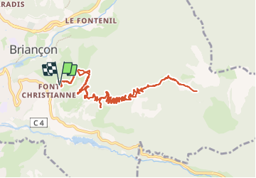
Trail Walking of 14.1 km to be discovered at Provence-Alpes-Côte d'Azur, Hautes-Alpes, Briançon. This trail is proposed by GuyVachet.

Description

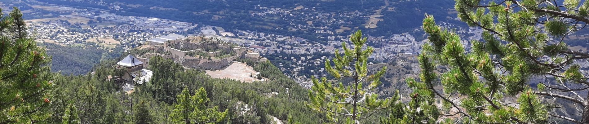
Aller-Retour à travers les anciennes fortifications de Briançon (et de la forêt de pins -ce qui présente un intérêt non négligeable ;-) pour atteindre les ruines de La Seyte. Le parcours commence au pied du fort des Trois Têtes, bel ouvrage dont il est un peu difficile d'embrasser toute l’étendue. Puis la montée emprunte la route empierrée qui alimentait le Fort du Randouillet, route qui devient sentier pour continuer en passant au Fort d'Anjou et de la Redoute (désormais privée) du Point du Jour. Les lacets se succèdent en frisant la crête du même nom et la pente s'adoucit pour l'approche de La Seyte au pied du Fort de l'Infernet. La descente s'effectue par le même itinéraire.

Elevation profile

Photos

Positioning

Country:
France
Region :
Provence-Alpes-Côte d'Azur
Department/Province :
Hautes-Alpes
Municipality :
Briançon
Location:
Unknown
Start:(UTM)
314458 ; 4973660 (32T) N.

Trails nearby

Trail Walking Briançon - Briançon Schappe-3 têtes - Photo
Walking
Orcal37

Walking

Easy
(2)
Briançon, Provence-Alpes-Côte d'Azur, Hautes-Alpes, France
6.5 km | 11 km-effort
2h 5min
Yes
Trail Mountain bike Val-des-Prés - Montgenèvre et col de la Lauze - Photo
Mountain bike
tracegps

Mountain bike

Very difficult
(1)
Val-des-Prés, Provence-Alpes-Côte d'Azur, Hautes-Alpes, France
38 km | 57 km-effort
3h 30min
Yes
Trail Walking Briançon - Circuit: Fort des 3 Têtes et Fort Dauphin - Photo
Walking
GUIDE
lhomme.ph

Walking

Easy
(2)
Briançon, Provence-Alpes-Côte d'Azur, Hautes-Alpes, France
7.4 km | 11.9 km-effort
2h 40min
Yes
Trail Walking Briançon - Briancon: Fort des Trois tètes - Photo
Walking
GUIDE
lhomme.ph

Walking

Very easy
Briançon, Provence-Alpes-Côte d'Azur, Hautes-Alpes, France
5 km | 8.5 km-effort
2h 8min
Yes
Trail Walking Briançon - Briancon: Le tour du Fort des 3 Têtes   - Photo
Walking
GUIDE
lhomme.ph

Walking

Medium
(1)
Briançon, Provence-Alpes-Côte d'Azur, Hautes-Alpes, France
7.7 km | 12.7 km-effort
1h 50min
Yes
Trail Mountain bike Montgenèvre - tour de montgenevre - Photo
Mountain bike
Vincentetourmy

Mountain bike

Very difficult
(1)
Montgenèvre, Provence-Alpes-Côte d'Azur, Hautes-Alpes, France
32 km | 50 km-effort
3h 15min
Yes
Trail Mountain bike Briançon - Briançon -Fort Gondran -Montgenevre  - Photo
Mountain bike
delalex

Mountain bike

Difficult
Briançon, Provence-Alpes-Côte d'Azur, Hautes-Alpes, France
24 km | 33 km-effort
2h 16min
No
Trail Mountain bike Briançon - Montgenevre par route militaire - Photo
Mountain bike
Fred Aguesse

Mountain bike

Difficult
(1)
Briançon, Provence-Alpes-Côte d'Azur, Hautes-Alpes, France
36 km | 53 km-effort
3h 41min
No
Trail Trail Puy-Saint-André - Clos du Vas - Puy Chalvin - Photo
Trail
toutankhcarton

Trail

Medium
Puy-Saint-André, Provence-Alpes-Côte d'Azur, Hautes-Alpes, France
7.4 km | 13.4 km-effort
1h 30min
Yes


Close
My subscriptions