Trail Mountain bike Briançon - Briançon -Fort Gondran -Montgenevre  - Photo

Briançon -Fort Gondran -Montgenevre

 delalex
delalex

User

© OpenStreetMap contributors
Length
Length
24 km
Max alt
Max alt
2449 m
Uphill gradient
Uphill gradient
481 m
Km-Effort
Km-Effort  
33 km
Min alt
Min alt
1311 m
Downhill gradient
Downhill gradient
1224 m
Boucle
Boucle
No
Creation date :
2023-10-10 10:04:40.0
Updated on :
2023-12-03 22:16:49.456

(0 Reviews)

Mountain bike
Mountain bike
2h16
Difficulty : Difficult

Scan this QR Code to open this trail in the SityTrail application

FREE GPS app for hiking

Logo SityTrail SityTrail

IGN / Geographical institutes

Download SityTrail from the App Store Download SityTrail from Google Play

Logo SityTrail SityTrail World

The world is yours!

Download SityTrail from the App Store Download SityTrail from Google Play Download SityTrail on Huawei AppGallery

About

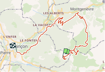
Trail Mountain bike of 24 km to be discovered at Provence-Alpes-Côte d'Azur, Hautes-Alpes, Briançon. This trail is proposed by delalex.

Description

Le départ de Briançon , de Maison Crénelée  à Poêt Morand ,  n'a pas été enregistré  .

Elevation profile

Photos

Positioning

Country:
France
Region :
Provence-Alpes-Côte d'Azur
Department/Province :
Hautes-Alpes
Municipality :
Briançon
Location:
Unknown
Start:(UTM)
318022 ; 4973176 (32T) N.

Trails nearby

Trail Walking Briançon - Briançon Schappe-3 têtes - Photo
Walking
Orcal37

Walking

Easy
(2)
Briançon, Provence-Alpes-Côte d'Azur, Hautes-Alpes, France
6.5 km | 11 km-effort
2h 5min
Yes
Trail Mountain bike Val-des-Prés - Montgenèvre et col de la Lauze - Photo
Mountain bike
tracegps

Mountain bike

Very difficult
(1)
Val-des-Prés, Provence-Alpes-Côte d'Azur, Hautes-Alpes, France
38 km | 57 km-effort
3h 30min
Yes
Trail Walking Val-des-Prés - le Chenaillet et le grand charvia - Photo
Walking
GUIDE
amiral13

Walking

Medium
Val-des-Prés, Provence-Alpes-Côte d'Azur, Hautes-Alpes, France
11.3 km | 19.5 km-effort
4h 17min
No
Trail Snowshoes Cervières - Le Laus - Vers Izoard par le sentier de la Mule - Photo
Snowshoes
Pek56

Snowshoes

Difficult
(3)
Cervières, Provence-Alpes-Côte d'Azur, Hautes-Alpes, France
12.3 km | 20 km-effort
5h 18min
Yes
Trail Walking Briançon - Circuit: Fort des 3 Têtes et Fort Dauphin - Photo
Walking
GUIDE
lhomme.ph

Walking

Easy
(2)
Briançon, Provence-Alpes-Côte d'Azur, Hautes-Alpes, France
7.4 km | 11.9 km-effort
2h 40min
Yes
Trail Walking Briançon - Briancon: Fort des Trois tètes - Photo
Walking
GUIDE
lhomme.ph

Walking

Very easy
Briançon, Provence-Alpes-Côte d'Azur, Hautes-Alpes, France
5 km | 8.5 km-effort
2h 8min
Yes
Trail Walking Briançon - Briancon: Le tour du Fort des 3 Têtes   - Photo
Walking
GUIDE
lhomme.ph

Walking

Medium
(1)
Briançon, Provence-Alpes-Côte d'Azur, Hautes-Alpes, France
7.7 km | 12.7 km-effort
1h 50min
Yes
Trail Mountain bike Montgenèvre - tour de montgenevre - Photo
Mountain bike
Vincentetourmy

Mountain bike

Very difficult
(1)
Montgenèvre, Provence-Alpes-Côte d'Azur, Hautes-Alpes, France
32 km | 50 km-effort
3h 15min
Yes
Trail Touring skiing Cervières - bas de Rochebrune - Photo
Touring skiing
nadd73

Touring skiing

Medium
Cervières, Provence-Alpes-Côte d'Azur, Hautes-Alpes, France
15.1 km | 29 km-effort
4h 5min
No


Close
My subscriptions