Trail Walking Lauzerte - lauzerte moissac - Photo
 fab0202
fab0202

User

© OpenStreetMap contributors
Length
Length
29 km
Max alt
Max alt
231 m
Uphill gradient
Uphill gradient
626 m
Km-Effort
Km-Effort  
38 km
Min alt
Min alt
73 m
Downhill gradient
Downhill gradient
746 m
Boucle
Boucle
No
Creation date :
2023-08-06 05:43:25.799
Updated on :
2023-08-06 14:24:03.054

(0 Reviews)

Walking
Walking
7h39
Difficulty : Medium

Scan this QR Code to open this trail in the SityTrail application

FREE GPS app for hiking

Logo SityTrail SityTrail

IGN / Geographical institutes

Download SityTrail from the App Store Download SityTrail from Google Play

Logo SityTrail SityTrail World

The world is yours!

Download SityTrail from the App Store Download SityTrail from Google Play Download SityTrail on Huawei AppGallery

About

Trail Walking of 29 km to be discovered at Occitania, Tarn-et-Garonne, Lauzerte. This trail is proposed by fab0202.

Description

belle rando avec campagne chapelle et pigeonnier. En fin de randonnée beaucoup de route.

Elevation profile

Photos

Positioning

Country:
France
Region :
Occitania
Department/Province :
Tarn-et-Garonne
Municipality :
Lauzerte
Location:
Unknown
Start:(UTM)
351524 ; 4902297 (31T) N.

Trails nearby

Trail Walking Lauzerte - Laurzerte ses alentours  - Photo
Walking
Curbelie

Walking

Medium
Lauzerte, Occitania, Tarn-et-Garonne, France
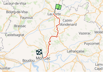
17.6 km | 23 km-effort
5h 7min
Yes
Trail Walking Lauzerte - Tronçon St Jacques Lauzerte Moissac  - Photo
Walking
choubaka77

Walking

Very difficult
Lauzerte, Occitania, Tarn-et-Garonne, France
29 km | 39 km-effort
7h 31min
No
Trail Walking Lauzerte - CC_Velay_EA_17_Lauzerte_Moissac_20080817 - Photo
Walking
patrickdanilo

Walking

Medium
Lauzerte, Occitania, Tarn-et-Garonne, France
26 km | 33 km-effort
7h 6min
No
Trail Walking Lauzerte - Lauzerte Rouille Lauzerte  - Photo
Walking
jgu5108

Walking

Medium
Lauzerte, Occitania, Tarn-et-Garonne, France
23 km | 32 km-effort
6h 4min
Yes
Trail Walking Lauzerte - La chapelle de Saint Sernin du Bosc - Lauzerte - Photo
Walking
tracegps

Walking

Medium
Lauzerte, Occitania, Tarn-et-Garonne, France
10.7 km | 15.2 km-effort
3h 0min
Yes
Trail Walking Montlauzun - Montlauzun - St Martin - Chemin de Compostelle - Photo
Walking
tracegps

Walking

Very difficult
Montlauzun, Occitania, Lot, France
23 km | 31 km-effort
9h 49min
No
Trail Walking Lauzerte - lauzerte-moissac 9.7.2017 - Photo
Walking
mota.filipe

Walking

Very easy
Lauzerte, Occitania, Tarn-et-Garonne, France
26 km | 34 km-effort
7h 59min
No
Trail Cycle Lauzerte - 2012-05-15 etape 6 - Photo
Cycle
FERAUD

Cycle

Easy
Lauzerte, Occitania, Tarn-et-Garonne, France
82 km | 96 km-effort
5h 57min
No
Trail Walking Lauzerte - Lauzerte - Photo
Walking
JujuDelfio

Walking

Medium
Lauzerte, Occitania, Tarn-et-Garonne, France
11.6 km | 16.7 km-effort
3h 0min
Yes


Close
My subscriptions