Trail Walking Briançon - Briançon - Cité Vauban - Photo
 astro45
astro45

User

© OpenStreetMap contributors
Length
Length
7 km
Max alt
Max alt
1459 m
Uphill gradient
Uphill gradient
327 m
Km-Effort
Km-Effort  
11.4 km
Min alt
Min alt
1222 m
Downhill gradient
Downhill gradient
327 m
Boucle
Boucle
Yes
Creation date :
2023-08-13 16:19:06.014
Updated on :
2023-08-13 19:01:19.372

(0 Reviews)

Walking
Walking
2h35
Difficulty : Medium

Scan this QR Code to open this trail in the SityTrail application

FREE GPS app for hiking

Logo SityTrail SityTrail

IGN / Geographical institutes

Download SityTrail from the App Store Download SityTrail from Google Play

Logo SityTrail SityTrail World

The world is yours!

Download SityTrail from the App Store Download SityTrail from Google Play Download SityTrail on Huawei AppGallery

About

Trail Walking of 7 km to be discovered at Provence-Alpes-Côte d'Azur, Hautes-Alpes, Briançon. This trail is proposed by astro45.

Description

Départ depuis la cité Vauban, descente de la Grande Rue. Prendre le chemin du Pont d'Asfeld. Monter à l'ancien Fort des Trois Têtes par le chemin. Contourner le fort et descendre vers le Parc de la Schappe par le chemin en forêt. Retour à la cité Vauban par le chemin et les rues.

Elevation profile

Photos

Positioning

Country:
France
Region :
Provence-Alpes-Côte d'Azur
Department/Province :
Hautes-Alpes
Municipality :
Briançon
Location:
Unknown
Start:(UTM)
313978 ; 4974689 (32T) N.

Trails nearby

Trail Walking Briançon - Briançon Schappe-3 têtes - Photo
Walking
Orcal37

Walking

Easy
(2)
Briançon, Provence-Alpes-Côte d'Azur, Hautes-Alpes, France
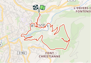
6.5 km | 11 km-effort
2h 5min
Yes
Trail Mountain bike Val-des-Prés - Montgenèvre et col de la Lauze - Photo
Mountain bike
tracegps

Mountain bike

Very difficult
(1)
Val-des-Prés, Provence-Alpes-Côte d'Azur, Hautes-Alpes, France
38 km | 57 km-effort
3h 30min
Yes
Trail Walking Briançon - Circuit: Fort des 3 Têtes et Fort Dauphin - Photo
Walking
GUIDE
lhomme.ph

Walking

Easy
(2)
Briançon, Provence-Alpes-Côte d'Azur, Hautes-Alpes, France
7.4 km | 11.9 km-effort
2h 40min
Yes
Trail Walking Briançon - Briancon: Fort des Trois tètes - Photo
Walking
GUIDE
lhomme.ph

Walking

Very easy
Briançon, Provence-Alpes-Côte d'Azur, Hautes-Alpes, France
5 km | 8.5 km-effort
2h 8min
Yes
Trail Walking Briançon - Briancon: Le tour du Fort des 3 Têtes   - Photo
Walking
GUIDE
lhomme.ph

Walking

Medium
(1)
Briançon, Provence-Alpes-Côte d'Azur, Hautes-Alpes, France
7.7 km | 12.7 km-effort
1h 50min
Yes
Trail Mountain bike Briançon - Briançon -Fort Gondran -Montgenevre  - Photo
Mountain bike
delalex

Mountain bike

Difficult
Briançon, Provence-Alpes-Côte d'Azur, Hautes-Alpes, France
24 km | 33 km-effort
2h 16min
No
Trail Mountain bike Briançon - Montgenevre par route militaire - Photo
Mountain bike
Fred Aguesse

Mountain bike

Difficult
(1)
Briançon, Provence-Alpes-Côte d'Azur, Hautes-Alpes, France
36 km | 53 km-effort
3h 41min
No
Trail Trail Puy-Saint-André - Clos du Vas - Puy Chalvin - Photo
Trail
toutankhcarton

Trail

Medium
Puy-Saint-André, Provence-Alpes-Côte d'Azur, Hautes-Alpes, France
7.4 km | 13.4 km-effort
1h 30min
Yes
Trail Running Puy-Saint-André - Clos du Vas - St Blaise - Briançon - Villar St Pancrace (Hautes-Alpes) - Photo
Running
toutankhcarton

Running

Medium
Puy-Saint-André, Provence-Alpes-Côte d'Azur, Hautes-Alpes, France
8 km | 10 km-effort
1h 7min
Yes


Close
My subscriptions