Trail Mountain bike Traubach-le-Haut - Traubach le haut  - Photo
© OpenStreetMap contributors
Length
Length
27 km
Max alt
Max alt
385 m
Uphill gradient
Uphill gradient
490 m
Km-Effort
Km-Effort  
34 km
Min alt
Min alt
287 m
Downhill gradient
Downhill gradient
490 m
Boucle
Boucle
Yes
Creation date :
2023-08-19 09:39:28.0
Updated on :
2023-08-19 11:28:25.944

(0 Reviews)

Mountain bike
Mountain bike
1h48
Difficulty : Easy

Scan this QR Code to open this trail in the SityTrail application

FREE GPS app for hiking

Logo SityTrail SityTrail

IGN / Geographical institutes

Download SityTrail from the App Store Download SityTrail from Google Play

Logo SityTrail SityTrail World

The world is yours!

Download SityTrail from the App Store Download SityTrail from Google Play Download SityTrail on Huawei AppGallery

About

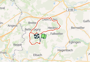
Trail Mountain bike of 27 km to be discovered at Grand Est, Haut-Rhin, Traubach-le-Haut. This trail is proposed by Alex Schlienger.

Description

Parcours de 28 kms brechaumont st cosme guevenaten hecken

Elevation profile

Positioning

Country:
France
Region :
Grand Est
Department/Province :
Haut-Rhin
Municipality :
Traubach-le-Haut
Location:
Unknown
Start:(UTM)
356470 ; 5280964 (32T) N.

Trails nearby

Trail Walking Burnhaupt-le-Bas - GR531 Diefmaten Gildwiller - Photo
Walking
helmut68

Walking

Easy
Burnhaupt-le-Bas, Grand Est, Haut-Rhin, France
6.1 km | 7.9 km-effort
1h 14min
No
Trail Walking Bellemagny - SityTrail - SityTrail - Bellemagny Vauthiermont - Photo
Walking
E.BURCK

Walking

Easy
Bellemagny, Grand Est, Haut-Rhin, France
12.2 km | 14.6 km-effort
3h 19min
Yes
Trail 4x4 Hecken - Alsace mardi 02 après midi - Photo
4x4
eldingue

4x4

Hecken, Grand Est, Haut-Rhin, France
87 km | 107 km-effort
3h 45min
No
Trail On foot Dannemarie - Chemins de traverses - Photo
On foot
patlog68

On foot

Easy
Dannemarie, Grand Est, Haut-Rhin, France
4 km | 4.8 km-effort
1h 4min
Yes
Trail Mountain bike Traubach-le-Haut - Traubach-le-haut / sternenberg - Photo
Mountain bike
Alex Schlienger

Mountain bike

Medium
Traubach-le-Haut, Grand Est, Haut-Rhin, France
29 km | 36 km-effort
1h 48min
Yes
Trail On foot Sternenberg - TL 02/20 - Sternenberg - Croix St Eloi - Bellemagny - St Cosme - Guevenatten - et retour par Hecken - Photo
On foot
patrickbeyrath

On foot

Very easy
Sternenberg, Grand Est, Haut-Rhin, France
13.1 km | 16.3 km-effort
Unknown
Yes
Trail On foot Guevenatten - TL 02/19 Guevenattenn - Vauthiermont - Photo
On foot
patrickbeyrath

On foot

Easy
Guevenatten, Grand Est, Haut-Rhin, France
14.9 km | 18.3 km-effort
Unknown
Yes
Trail Walking Guevenatten - 19.02.28.Guewenatten  - Photo
Walking
ROPPJP

Walking

Very easy
Guevenatten, Grand Est, Haut-Rhin, France
15.4 km | 18.8 km-effort
4h 20min
Yes
Trail Motor Traubach-le-Haut - a-frankrijk-frankrijk-en-zwitserland-doubs-en-jura - Photo
Motor
gpstracks

Motor

Very easy
Traubach-le-Haut, Grand Est, Haut-Rhin, France
208 km | 327 km-effort
Unknown
Yes


Close
My subscriptions