Trail Walking Estavar - Estavar - Sant-Vicenç- Estavar - Photo

Estavar - Sant-Vicenç- Estavar

© OpenStreetMap contributors
Length
Length
12.1 km
Max alt
Max alt
1515 m
Uphill gradient
Uphill gradient
398 m
Km-Effort
Km-Effort  
17.4 km
Min alt
Min alt
1221 m
Downhill gradient
Downhill gradient
399 m
Boucle
Boucle
Yes
Creation date :
2023-09-03 14:55:23.679
Updated on :
2023-09-03 15:14:18.26

(0 Reviews)

Walking
Walking
3h57
Difficulty : Difficult

Scan this QR Code to open this trail in the SityTrail application

FREE GPS app for hiking

Logo SityTrail SityTrail

IGN / Geographical institutes

Download SityTrail from the App Store Download SityTrail from Google Play

Logo SityTrail SityTrail World

The world is yours!

Download SityTrail from the App Store Download SityTrail from Google Play Download SityTrail on Huawei AppGallery

About

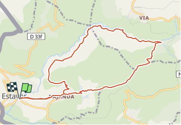
Trail Walking of 12.1 km to be discovered at Occitania, Pyrénées-Orientales, Estavar. This trail is proposed by rene091957.

Description

Estavar, Bajande, corniche Rec de Bajande, Sant Vicenç de Portoles, descente sur Bajande, Estavar.

Elevation profile

Positioning

Country:
France
Region :
Occitania
Department/Province :
Pyrénées-Orientales
Municipality :
Estavar
Location:
Unknown
Start:(UTM)
417631 ; 4702219 (31T) N.

Trails nearby

Trail Walking Nahuja - boucle de Nahuja - Photo
Walking
crijack

Walking

Medium
(1)
Nahuja, Occitania, Pyrénées-Orientales, France
11.8 km | 18.2 km-effort
2h 44min
Yes
Trail Snowshoes Font-Romeu-Odeillo-Via - pic dels moros - Photo
Snowshoes
jpipacific

Snowshoes

Medium
(1)
Font-Romeu-Odeillo-Via, Occitania, Pyrénées-Orientales, France
12.6 km | 19.4 km-effort
4h 46min
Yes
Trail Walking Font-Romeu-Odeillo-Via - Font Romeu Egat - Photo
Walking
crijack

Walking

Medium
(2)
Font-Romeu-Odeillo-Via, Occitania, Pyrénées-Orientales, France
2.5 km | 3.4 km-effort
44min
Yes
Trail Snowshoes Font-Romeu-Odeillo-Via - Pic dels Moros avec Pierre - Photo
Snowshoes
jpipacific

Snowshoes

Medium
(1)
Font-Romeu-Odeillo-Via, Occitania, Pyrénées-Orientales, France
10.5 km | 15.9 km-effort
4h 4min
Yes
Trail Walking Égat - Egat  Puig  Moro - Photo
Walking
ohelluin

Walking

Medium
(1)
Égat, Occitania, Pyrénées-Orientales, France
13.4 km | 19.3 km-effort
4h 51min
Yes
Trail Walking Égat - La croix d'Egat - Photo
Walking
ochamley

Walking

Easy
(1)
Égat, Occitania, Pyrénées-Orientales, France
7.1 km | 10.4 km-effort
2h 2min
Yes
Trail Walking Égat - Le Pic dels Moros - Photo
Walking
tracegps

Walking

Difficult
(2)
Égat, Occitania, Pyrénées-Orientales, France
12.1 km | 18.8 km-effort
5h 30min
Yes
Trail Mountain bike Font-Romeu-Odeillo-Via - Espace VTT FFC Pyrénées Catalanes - Circuit n° 6 - Forêt d'Egat - Photo
Mountain bike
tracegps

Mountain bike

Medium
(2)
Font-Romeu-Odeillo-Via, Occitania, Pyrénées-Orientales, France
7.6 km | 10.1 km-effort
1h 0min
Yes
Trail Walking Estavar - 20220328 Estavar-Tartassonne(?) - Photo
Walking
ThonyM

Walking

Medium
Estavar, Occitania, Pyrénées-Orientales, France
14.8 km | 22 km-effort
3h 16min
Yes


Close
My subscriptions