Trail Mountain bike Font-Romeu-Odeillo-Via - Espace VTT FFC Pyrénées Catalanes - Circuit n° 6 - Forêt d'Egat - Photo

Espace VTT FFC Pyrénées Catalanes - Circuit n° 6 - Forêt d'Egat

 tracegps
tracegps

User

© OpenStreetMap contributors
Length
Length
7.6 km
Max alt
Max alt
1877 m
Uphill gradient
Uphill gradient
187 m
Km-Effort
Km-Effort  
10.1 km
Min alt
Min alt
1745 m
Downhill gradient
Downhill gradient
188 m
Boucle
Boucle
Yes
Creation date :
2014-12-10 00:00:00.0
Updated on :
2014-12-10 00:00:00.0

(2 Reviews)

Mountain bike
Mountain bike
1h00
Difficulty : Medium

Scan this QR Code to open this trail in the SityTrail application

FREE GPS app for hiking

Logo SityTrail SityTrail

IGN / Geographical institutes

Download SityTrail from the App Store Download SityTrail from Google Play

Logo SityTrail SityTrail World

The world is yours!

Download SityTrail from the App Store Download SityTrail from Google Play Download SityTrail on Huawei AppGallery

About

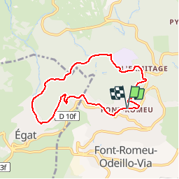
Trail Mountain bike of 7.6 km to be discovered at Occitania, Pyrénées-Orientales, Font-Romeu-Odeillo-Via. This trail is proposed by tracegps.

Description

Espace VTT FFC Pyrénées Catalanes Circuit labellisé par la Fédération Française de Cyclisme. Passage à proximité de l'incontournable chapelle de l'Ermitage. Agréable descente dans la forêt d'Egat. Sentier de la Soulane emprunté depuis des millénaires par les pèlerins. Sentier en sous-bois sur pistes roulantes agrémenté de portions de routes.

Elevation profile

Photos

Positioning

Country:
France
Region :
Occitania
Department/Province :
Pyrénées-Orientales
Municipality :
Font-Romeu-Odeillo-Via
Location:
Unknown
Start:(UTM)
421301 ; 4706325 (31T) N.

Comments

Please log in to post a review or rate the element


Cet outils est très pratique et approprié aux activités sportives. Qualité des cartes irréprochable. J'ai testé cette année Sity Trail Espagne gratuit quand on est déjà abonné, les cartes sont nettement moins précises


Trails nearby

Trail Walking Font-Romeu-Odeillo-Via - Coll del Pam lac des  Bouillouses - Photo
Walking
jcmartin

Walking

Medium
(2)
Font-Romeu-Odeillo-Via, Occitania, Pyrénées-Orientales, France
13.3 km | 19.3 km-effort
4h 10min
Yes
Trail Walking Eyne - Eyne,col de Nuria,pic d'Eyne,Torre d'Eyne,Eyne. - Photo
Walking
Machaon6

Walking

Very difficult
(1)
Eyne, Occitania, Pyrénées-Orientales, France
24 km | 43 km-effort
8h 44min
Yes
Trail Snowshoes Font-Romeu-Odeillo-Via - pic dels moros - Photo
Snowshoes
jpipacific

Snowshoes

Medium
(1)
Font-Romeu-Odeillo-Via, Occitania, Pyrénées-Orientales, France
12.6 km | 19.4 km-effort
4h 46min
Yes
Trail Walking Font-Romeu-Odeillo-Via - Font Romeu Egat - Photo
Walking
crijack

Walking

Medium
(2)
Font-Romeu-Odeillo-Via, Occitania, Pyrénées-Orientales, France
2.5 km | 3.4 km-effort
44min
Yes
Trail Snowshoes Font-Romeu-Odeillo-Via - Pic dels Moros avec Pierre - Photo
Snowshoes
jpipacific

Snowshoes

Medium
(1)
Font-Romeu-Odeillo-Via, Occitania, Pyrénées-Orientales, France
10.5 km | 15.9 km-effort
4h 4min
Yes
Trail Walking Égat - Egat  Puig  Moro - Photo
Walking
ohelluin

Walking

Medium
(1)
Égat, Occitania, Pyrénées-Orientales, France
13.4 km | 19.3 km-effort
4h 51min
Yes
Trail Walking Égat - La croix d'Egat - Photo
Walking
ochamley

Walking

Easy
(1)
Égat, Occitania, Pyrénées-Orientales, France
7.1 km | 10.4 km-effort
2h 2min
Yes
Trail Walking Égat - Le Pic dels Moros - Photo
Walking
tracegps

Walking

Difficult
(2)
Égat, Occitania, Pyrénées-Orientales, France
12.1 km | 18.8 km-effort
5h 30min
Yes
Trail Walking Eyne - Vallée d'Eyne - Photo
Walking
GUIDE
nadinebondoux

Walking

Medium
Eyne, Occitania, Pyrénées-Orientales, France
10.7 km | 17.6 km-effort
4h 40min
Yes


Close
My subscriptions