Trail Walking Saint-Bonnet-en-Champsaur - Les infournas  -  Lac des Barbeyroux 22/09/23 - Photo

Les infournas - Lac des Barbeyroux 22/09/23

 R@ph
R@ph

User GUIDE

© OpenStreetMap contributors
Length
Length
10.1 km
Max alt
Max alt
1713 m
Uphill gradient
Uphill gradient
446 m
Km-Effort
Km-Effort  
16 km
Min alt
Min alt
1307 m
Downhill gradient
Downhill gradient
454 m
Boucle
Boucle
Yes
Creation date :
2023-09-22 12:55:27.893
Updated on :
2023-09-22 13:24:59.169

(0 Reviews)

Walking
Walking
3h38
Difficulty : Difficult

Scan this QR Code to open this trail in the SityTrail application

FREE GPS app for hiking

Logo SityTrail SityTrail

IGN / Geographical institutes

Download SityTrail from the App Store Download SityTrail from Google Play

Logo SityTrail SityTrail World

The world is yours!

Download SityTrail from the App Store Download SityTrail from Google Play Download SityTrail on Huawei AppGallery

About

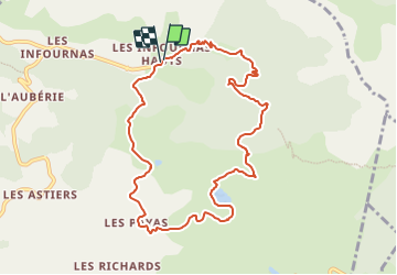
Trail Walking of 10.1 km to be discovered at Provence-Alpes-Côte d'Azur, Hautes-Alpes, Saint-Bonnet-en-Champsaur. This trail is proposed by R@ph.

Description

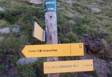
Un parking est disponible au départ des Infournas Hauts dirigez vous vers la maison forestière de Subeyrannes, suivez ensuite le chemin pour arriver au Serre du Moulin. Une barrière est présente sur le chemin de droite prenez à gauche, après une légère montée, vous redescendez ensuite vers le lac des Barbeyroux.

Elevation profile

Photos

Positioning

Country:
France
Region :
Provence-Alpes-Côte d'Azur
Department/Province :
Hautes-Alpes
Municipality :
Saint-Bonnet-en-Champsaur
Location:
Les Infournas
Start:(UTM)
271125 ; 4955145 (32T) N.

Trails nearby

Trail Walking Saint-Michel-de-Chaillol - Tête ouest de Mal Cros 11/08/18 - Photo
Walking
GUIDE
R@ph

Walking

Very difficult
Saint-Michel-de-Chaillol, Provence-Alpes-Côte d'Azur, Hautes-Alpes, France
21 km | 40 km-effort
8h 2min
Yes
Trail Walking La Motte-en-Champsaur - Jas de Jartier - Photo
Walking
Marco05

Walking

Difficult
La Motte-en-Champsaur, Provence-Alpes-Côte d'Azur, Hautes-Alpes, France
13.7 km | 24 km-effort
5h 22min
Yes
Trail Walking Saint-Michel-de-Chaillol - Col de l'Escalier - Photo
Walking
Marco05

Walking

Difficult
Saint-Michel-de-Chaillol, Provence-Alpes-Côte d'Azur, Hautes-Alpes, France
16 km | 27 km-effort
6h 13min
Yes
Trail Walking Saint-Michel-de-Chaillol - Pic Queyrel - Photo
Walking
Marco05

Walking

Difficult
Saint-Michel-de-Chaillol, Provence-Alpes-Côte d'Azur, Hautes-Alpes, France
10.4 km | 19.8 km-effort
4h 29min
Yes
Trail Walking Saint-Michel-de-Chaillol - Pic du Tourond - Photo
Walking
Marco05

Walking

Very difficult
Saint-Michel-de-Chaillol, Provence-Alpes-Côte d'Azur, Hautes-Alpes, France
13.7 km | 27 km-effort
6h 14min
Yes
Trail Walking Saint-Michel-de-Chaillol - Lac de Malcros - Photo
Walking
Marco05

Walking

Very difficult
Saint-Michel-de-Chaillol, Provence-Alpes-Côte d'Azur, Hautes-Alpes, France
18.7 km | 34 km-effort
7h 43min
Yes
Trail Walking Saint-Bonnet-en-Champsaur - Col de l'Escalier - Photo
Walking
flip38

Walking

Medium
Saint-Bonnet-en-Champsaur, Provence-Alpes-Côte d'Azur, Hautes-Alpes, France
19.6 km | 33 km-effort
6h 3min
Yes
Trail Walking Saint-Michel-de-Chaillol - pic de queyrel - Photo
Walking
nadd73

Walking

Very difficult
Saint-Michel-de-Chaillol, Provence-Alpes-Côte d'Azur, Hautes-Alpes, France
10.8 km | 21 km-effort
5h 40min
Yes
Trail Walking Saint-Michel-de-Chaillol - Chaillol - Photo
Walking
rarnaud

Walking

Easy
Saint-Michel-de-Chaillol, Provence-Alpes-Côte d'Azur, Hautes-Alpes, France
13.1 km | 19.2 km-effort
4h 19min
Yes


Close
My subscriptions