Trail Walking Saint-Michel-de-Chaillol - Pic Queyrel - Photo
 Marco05
Marco05

User

© OpenStreetMap contributors
Length
Length
10.4 km
Max alt
Max alt
2414 m
Uphill gradient
Uphill gradient
699 m
Km-Effort
Km-Effort  
19.8 km
Min alt
Min alt
1701 m
Downhill gradient
Downhill gradient
699 m
Boucle
Boucle
Yes
Creation date :
2022-04-01 12:02:48.974
Updated on :
2022-12-15 12:43:20.867

(0 Reviews)

Walking
Walking
4h29
Difficulty : Difficult

Scan this QR Code to open this trail in the SityTrail application

FREE GPS app for hiking

Logo SityTrail SityTrail

IGN / Geographical institutes

Download SityTrail from the App Store Download SityTrail from Google Play

Logo SityTrail SityTrail World

The world is yours!

Download SityTrail from the App Store Download SityTrail from Google Play Download SityTrail on Huawei AppGallery

About

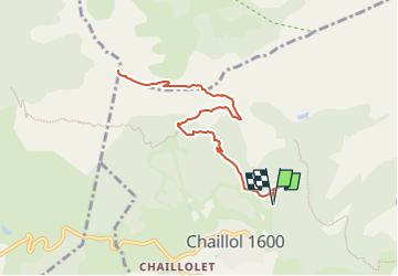
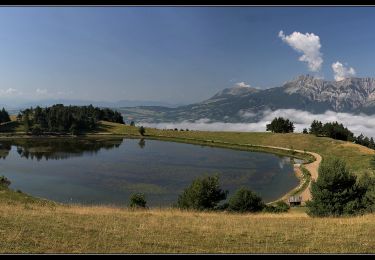
Trail Walking of 10.4 km to be discovered at Provence-Alpes-Côte d'Azur, Hautes-Alpes, Saint-Michel-de-Chaillol. This trail is proposed by Marco05.

Description

Départ de la station Chaillol 1600.
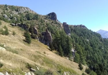
On peut monter la voiture à 1700m par la piste qui n'est pas en très bon état.
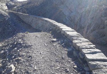
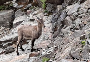
Deux passages dans lesquels on doit mettre les mains.
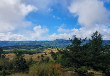
Donc, une randonnée qui demande un peu de souplesse et de ne pas avoir trops peur du vide.

Elevation profile

Photos

Positioning

Country:
France
Region :
Provence-Alpes-Côte d'Azur
Department/Province :
Hautes-Alpes
Municipality :
Saint-Michel-de-Chaillol
Location:
Unknown
Start:(UTM)
275701 ; 4952690 (32T) N.

Trails nearby

Trail Walking Saint-Jean-Saint-Nicolas - Circuit de Costebelle - Photo
Walking
Dervalmarc

Walking

Very easy
(2)
Saint-Jean-Saint-Nicolas, Provence-Alpes-Côte d'Azur, Hautes-Alpes, France
7.4 km | 12.1 km-effort
2h 16min
Yes
Trail Walking Saint-Bonnet-en-Champsaur - Les infournas  -  Lac des Barbeyroux 22/09/23 - Photo
Walking
GUIDE
R@ph

Walking

Difficult
Saint-Bonnet-en-Champsaur, Provence-Alpes-Côte d'Azur, Hautes-Alpes, France
10.1 km | 16 km-effort
3h 38min
Yes
Trail Walking Saint-Michel-de-Chaillol - Tête ouest de Mal Cros 11/08/18 - Photo
Walking
GUIDE
R@ph

Walking

Very difficult
Saint-Michel-de-Chaillol, Provence-Alpes-Côte d'Azur, Hautes-Alpes, France
21 km | 40 km-effort
8h 2min
Yes
Trail Walking Saint-Jean-Saint-Nicolas - Pont Ricous Pelissier Coste Belle Pont du Fossé - Photo
Walking
Orage

Walking

Easy
(2)
Saint-Jean-Saint-Nicolas, Provence-Alpes-Côte d'Azur, Hautes-Alpes, France
11.3 km | 21 km-effort
1h 57min
Yes
Trail Walking Saint-Michel-de-Chaillol - Col de l'Escalier - Photo
Walking
Marco05

Walking

Difficult
Saint-Michel-de-Chaillol, Provence-Alpes-Côte d'Azur, Hautes-Alpes, France
16 km | 27 km-effort
6h 13min
Yes
Trail Walking Saint-Michel-de-Chaillol - Pic du Tourond - Photo
Walking
Marco05

Walking

Very difficult
Saint-Michel-de-Chaillol, Provence-Alpes-Côte d'Azur, Hautes-Alpes, France
13.7 km | 27 km-effort
6h 14min
Yes
Trail Walking Saint-Michel-de-Chaillol - Lac de Malcros - Photo
Walking
Marco05

Walking

Very difficult
Saint-Michel-de-Chaillol, Provence-Alpes-Côte d'Azur, Hautes-Alpes, France
18.7 km | 34 km-effort
7h 43min
Yes
Trail Walking Saint-Bonnet-en-Champsaur - Col de l'Escalier - Photo
Walking
flip38

Walking

Medium
Saint-Bonnet-en-Champsaur, Provence-Alpes-Côte d'Azur, Hautes-Alpes, France
19.6 km | 33 km-effort
6h 3min
Yes
Trail Walking Saint-Michel-de-Chaillol - pic de queyrel - Photo
Walking
nadd73

Walking

Very difficult
Saint-Michel-de-Chaillol, Provence-Alpes-Côte d'Azur, Hautes-Alpes, France
10.8 km | 21 km-effort
5h 40min
Yes


Close
My subscriptions