![](/images/other/stat-length.png)
![Trail Walking Tías - LZ4 - Lanzarote 2 - Photo](https://media.geolcdn.com/t/1900/400/ext.pjpeg?maxdim=2&url=https%3A%2F%2Fmedia.geolcdn.com%2Ff%2F1647facf-eedd-4713-a3c6-df042040e1d4.jpg)
LZ4 - Lanzarote 2
patjobou
User
![Length](/images/other/stat-length.png)
Length
2.8 km
![Max alt](https://static1.geolcdn.com/siteimages/upload/files/1508320355ic_sort_altitude_max_24dp.png)
Max alt
45 m
![Uphill gradient](https://static1.geolcdn.com/siteimages/upload/files/1508320355ic_sort_den_pos_24dp.png)
Uphill gradient
51 m
![Km-Effort](/images/other/stat-length.png)
Km-Effort
3.4 km
![Min alt](https://static1.geolcdn.com/siteimages/upload/files/1508320355ic_sort_altitude_min_24dp.png)
Min alt
9 m
![Downhill gradient](https://static1.geolcdn.com/siteimages/upload/files/1508320355ic_sort_den_neg_24dp.png)
Downhill gradient
51 m
![Boucle](https://static1.geolcdn.com/siteimages/upload/files/16400158638029165_repeat_loop_refresh_sync_direction_icon.png)
Boucle
Yes
Creation date :
2023-09-20 17:10:29.511
Updated on :
2023-09-30 20:34:41.5
![Walking](https://static1.geolcdn.com/sitytour/trail-icons/101.png)
50m
Difficulty : Easy
![Scan this QR Code to open this trail in the SityTrail application](https://capi.geolives.com/qq0zvz2zws4bq2lad0pu/sitytour/trails/3814952/qr.png?size=200)
FREE GPS app for hiking
About
Trail Walking of 2.8 km to be discovered at Canary Islands, Las Palmas, Tías. This trail is proposed by patjobou.
Description
De Puerto del Carmen a Puerto Calero au coucher de soleil. Belle boucle, beaux paysages. Aller jusqu'au port ne présente pas beaucoup d'intérêt après cette belle traverser sauvage , à moins d'y boire un coup avant de revenir . Itinéraire facile par beau temps.
Positioning
Country:
Spain
Region :
Canary Islands
Department/Province :
Las Palmas
Municipality :
Tías
Location:
Unknown
Start:(Dec)
Start:(UTM)
629036 ; 3200078 (28R) N.
Comments
Trails nearby
![Trail Walking - la Asomada - la Geria - Montana de Guardilama - Photo](https://media.geolcdn.com/t/375/260/ext.jpg?maxdim=2&url=https%3A%2F%2Fmedia.geolcdn.com%2Ff%2Fa40db8e8-51bd-4bdb-86cb-b0ae83ea96d6.jpg)
![Walking Walking](https://static1.geolcdn.com/sitytour/trail-icons/101.png)
la Asomada - la Geria - Montana de Guardilama
Walking
Medium
(2)
,
Canary Islands,
Las Palmas,
Spain
![](/images/other/stat-length.png)
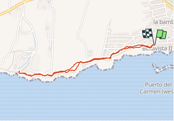
6.2 km | 10 km-effort
2h 30min
![](https://static1.geolcdn.com/siteimages/upload/files/16400158638029165_repeat_loop_refresh_sync_direction_icon.png)
Yes
![Trail Other activity Tías - gffgh - Photo](https://media.geolcdn.com/t/375/260/ext.jpg?maxdim=2&url=https%3A%2F%2Fstatic1.geolcdn.com%2Fsiteimages%2Fupload%2Ffiles%2F1545311037marcheuse_200dpi.jpg)
![Other activity Other activity](https://static1.geolcdn.com/sitytour/trail-icons/900.png)
gffgh
Other activity
Very easy
Tías,
Canary Islands,
Las Palmas,
Spain
![](/images/other/stat-length.png)
12.4 km | 14.7 km-effort
1h 14min
![](https://static1.geolcdn.com/siteimages/upload/files/16400158638029165_repeat_loop_refresh_sync_direction_icon.png)
No
![Trail Walking Tías - puerto del carmen arecif - Photo](https://media.geolcdn.com/t/375/260/ext.jpg?maxdim=2&url=https%3A%2F%2Fstatic1.geolcdn.com%2Fsiteimages%2Fupload%2Ffiles%2F1553511878bg_sport_marche.png)
![Walking Walking](https://static1.geolcdn.com/sitytour/trail-icons/101.png)
puerto del carmen arecif
Walking
Very easy
Tías,
Canary Islands,
Las Palmas,
Spain
![](/images/other/stat-length.png)
23 km | 27 km-effort
6h 13min
![](https://static1.geolcdn.com/siteimages/upload/files/16400158638029165_repeat_loop_refresh_sync_direction_icon.png)
No
![Trail Walking Tías - xc Carmen 210227 Lanzarote - Photo](https://media.geolcdn.com/t/375/260/ext.jpg?maxdim=2&url=https%3A%2F%2Fstatic1.geolcdn.com%2Fsiteimages%2Fupload%2Ffiles%2F1553511878bg_sport_marche.png)
![Walking Walking](https://static1.geolcdn.com/sitytour/trail-icons/101.png)
xc Carmen 210227 Lanzarote
Walking
Very easy
Tías,
Canary Islands,
Las Palmas,
Spain
![](/images/other/stat-length.png)
4 km | 4.8 km-effort
1h 24min
![](https://static1.geolcdn.com/siteimages/upload/files/16400158638029165_repeat_loop_refresh_sync_direction_icon.png)
Yes
![Trail Mountain bike Tías - Tías - Photo](https://media.geolcdn.com/t/375/260/ext.jpg?maxdim=2&url=https%3A%2F%2Fstatic1.geolcdn.com%2Fsiteimages%2Fupload%2Ffiles%2F1524743154velo.jpg)
![Mountain bike Mountain bike](https://static1.geolcdn.com/sitytour/trail-icons/202.png)
![Trail Other activity Tías - puerto del Carmen - Photo](https://media.geolcdn.com/t/375/260/ext.jpg?maxdim=2&url=https%3A%2F%2Fstatic1.geolcdn.com%2Fsiteimages%2Fupload%2Ffiles%2F1545311037marcheuse_200dpi.jpg)
![Other activity Other activity](https://static1.geolcdn.com/sitytour/trail-icons/900.png)
puerto del Carmen
Other activity
Very easy
Tías,
Canary Islands,
Las Palmas,
Spain
![](/images/other/stat-length.png)
1.1 km | 1.3 km-effort
Unknown
![](https://static1.geolcdn.com/siteimages/upload/files/16400158638029165_repeat_loop_refresh_sync_direction_icon.png)
No