Trail Mountain bike Belfort - Transterritoire VTT 2023 - 50 kms  - Belfort - Brognard - Héricourt - Photo

Transterritoire VTT 2023 - 50 kms - Belfort - Brognard - Héricourt

 Bart2015
Bart2015

User

© OpenStreetMap contributors
Length
Length
49 km
Max alt
Max alt
445 m
Uphill gradient
Uphill gradient
769 m
Km-Effort
Km-Effort  
59 km
Min alt
Min alt
320 m
Downhill gradient
Downhill gradient
768 m
Boucle
Boucle
Yes
Creation date :
2023-10-01 06:37:56.63
Updated on :
2023-10-17 10:59:56.713

(0 Reviews)

Mountain bike
Mountain bike
4h07
Difficulty : Very difficult

Scan this QR Code to open this trail in the SityTrail application

FREE GPS app for hiking

Logo SityTrail SityTrail

IGN / Geographical institutes

Download SityTrail from the App Store Download SityTrail from Google Play

Logo SityTrail SityTrail World

The world is yours!

Download SityTrail from the App Store Download SityTrail from Google Play Download SityTrail on Huawei AppGallery

About

Trail Mountain bike of 49 km to be discovered at Bourgogne-Franche-Comté, Territoire-de-Belfort, Belfort. This trail is proposed by Bart2015.

Description

Circuit 50 kms Transterritoire 2023
Bonne balade, soyez prudents ...

Elevation profile

Positioning

Country:
France
Region :
Bourgogne-Franche-Comté
Department/Province :
Territoire-de-Belfort
Municipality :
Belfort
Location:
Unknown
Start:(UTM)
338125 ; 5278861 (32T) N.

Trails nearby

Trail Mountain bike Andelnans - Tour d'Essert - Photo
Mountain bike
qlqin

Mountain bike

Easy
(2)
Andelnans, Bourgogne-Franche-Comté, Territoire-de-Belfort, France
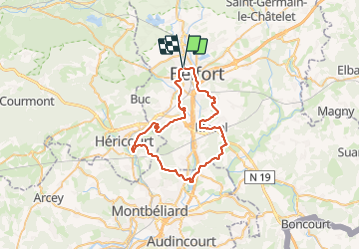
29 km | 36 km-effort
2h 12min
Yes
Trail Walking Belfort - Offemont - La ballade des Champs Cerisiers - Photo
Walking
bmorel@orange.fr

Walking

Easy
(1)
Belfort, Bourgogne-Franche-Comté, Territoire-de-Belfort, France
8.8 km | 10.8 km-effort
Unknown
Yes
Trail Walking Sermamagny - Veronne PC - Photo
Walking
Papamoju

Walking

Very easy
(2)
Sermamagny, Bourgogne-Franche-Comté, Territoire-de-Belfort, France
8.1 km | 9 km-effort
1h 59min
Yes
Trail Walking Châlonvillars - Châlonvillars - Fort du Salbert - Evette-Salbert - Photo
Walking
Bart2015

Walking

Difficult
(1)
Châlonvillars, Bourgogne-Franche-Comté, Haute-Saône, France
11 km | 15.8 km-effort
3h 36min
Yes
Trail Mountain bike Châlonvillars - Châlonvillars - Fort Giromagny en passant au milieu des étangs - Photo
Mountain bike
Bart2015

Mountain bike

Very difficult
Châlonvillars, Bourgogne-Franche-Comté, Haute-Saône, France
40 km | 51 km-effort
3h 31min
Yes
Trail Mountain bike Châlonvillars - Châlonvillars - Menhir - Mandrevillars - Fort Essert et du Salbert - Photo
Mountain bike
Bart2015

Mountain bike

Very difficult
Châlonvillars, Bourgogne-Franche-Comté, Haute-Saône, France
31 km | 42 km-effort
2h 53min
Yes
Trail Walking Châlonvillars - Châlonvillars - le mehnir - Mandrevillars - Photo
Walking
Bart2015

Walking

Medium
Châlonvillars, Bourgogne-Franche-Comté, Haute-Saône, France
13.4 km | 17.1 km-effort
2h 39min
Yes
Trail Walking Châlonvillars - Châlonvillars - Mandrevillars - Photo
Walking
Bart2015

Walking

Easy
Châlonvillars, Bourgogne-Franche-Comté, Haute-Saône, France
9.5 km | 11.9 km-effort
1h 33min
Yes
Trail On foot Offemont - Sentier de la Roselière - Photo
On foot
PRO

On foot

Easy
Offemont, Bourgogne-Franche-Comté, Territoire-de-Belfort, France
3.9 km | 4.3 km-effort
58min
Yes


Close
My subscriptions