Trail Walking Saint-Astier - St Astier Puy-Ferrat 10km - Photo

St Astier Puy-Ferrat 10km

 YV24
YV24

User

© OpenStreetMap contributors
Length
Length
10.3 km
Max alt
Max alt
195 m
Uphill gradient
Uphill gradient
207 m
Km-Effort
Km-Effort  
13 km
Min alt
Min alt
76 m
Downhill gradient
Downhill gradient
208 m
Boucle
Boucle
Yes
Creation date :
2015-02-07 00:00:00.0
Updated on :
2015-02-07 00:00:00.0

(0 Reviews)

Walking
Walking
2h53
Difficulty : Easy

Scan this QR Code to open this trail in the SityTrail application

FREE GPS app for hiking

Logo SityTrail SityTrail

IGN / Geographical institutes

Download SityTrail from the App Store Download SityTrail from Google Play

Logo SityTrail SityTrail World

The world is yours!

Download SityTrail from the App Store Download SityTrail from Google Play Download SityTrail on Huawei AppGallery

About

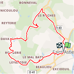
Trail Walking of 10.3 km to be discovered at New Aquitaine, Dordogne, Saint-Astier. This trail is proposed by YV24.

Description

Selon PDIPR n°2 carte St Astier. Circuit bien tracé, vallonné, praticable en tout temps. Petite "Chapelle des Bois" à l'origine du nom de St Astier.

Elevation profile

Positioning

Country:
France
Region :
New Aquitaine
Department/Province :
Dordogne
Municipality :
Saint-Astier
Location:
Unknown
Start:(UTM)
305664 ; 5002053 (31T) N.

Trails nearby

Trail Walking Saint-Astier - 24 Saint-Astier  - Photo
Walking
Patxito

Walking

Easy
(1)
Saint-Astier, New Aquitaine, Dordogne, France
11.4 km | 14.3 km-effort
2h 42min
Yes
Trail Walking Saint-Astier - GR654 ST ASTIER BERGERAC PINEL - Photo
Walking
kmedone

Walking

Difficult
(3)
Saint-Astier, New Aquitaine, Dordogne, France
122 km | 150 km-effort
31h 13min
No
Trail On foot Saint-Aquilin - Boucle des Châteaux - Photo
On foot
PRO

On foot

Easy
Saint-Aquilin, New Aquitaine, Dordogne, France
11.3 km | 15.4 km-effort
3h 29min
No
Trail Walking Saint-Aquilin - St Aquilin Chateaux 12km - Photo
Walking
YV24

Walking

Easy
(1)
Saint-Aquilin, New Aquitaine, Dordogne, France
11.9 km | 16.3 km-effort
3h 33min
Yes
Trail On foot Saint-Aquilin - Promenade de Charroux - Photo
On foot
PRO

On foot

Easy
Saint-Aquilin, New Aquitaine, Dordogne, France
4.2 km | 5.8 km-effort
1h 19min
Yes
Trail Walking Annesse-et-Beaulieu - Boucle de Gravelle - Photo
Walking
CC.RIDER

Walking

Difficult
Annesse-et-Beaulieu, New Aquitaine, Dordogne, France
13.1 km | 16.2 km-effort
3h 40min
Yes
Trail Walking Saint-Astier - Boucle de Saint Astier - Photo
Walking
CC.RIDER

Walking

Difficult
Saint-Astier, New Aquitaine, Dordogne, France
12.6 km | 16.3 km-effort
3h 42min
Yes
Trail Walking Léguillac-de-l'Auche - Leguillac 12km - Photo
Walking
amelie14

Walking

Medium
Léguillac-de-l'Auche, New Aquitaine, Dordogne, France
12.1 km | 16.1 km-effort
2h 45min
Yes
Trail Walking Léguillac-de-l'Auche - 24 Léguillac de l'Auche - Photo
Walking
Patxito

Walking

Easy
Léguillac-de-l'Auche, New Aquitaine, Dordogne, France
13.8 km | 18 km-effort
3h 57min
Yes


Close
My subscriptions