Trail Walking Saint-Hippolyte - St-Hippolyte - Rorschwihr - Grasberg - Bergheim - Reichenberg - Rodern - Photo

St-Hippolyte - Rorschwihr - Grasberg - Bergheim - Reichenberg - Rodern

© OpenStreetMap contributors
Length
Length
17.3 km
Max alt
Max alt
381 m
Uphill gradient
Uphill gradient
353 m
Km-Effort
Km-Effort  
22 km
Min alt
Min alt
202 m
Downhill gradient
Downhill gradient
353 m
Boucle
Boucle
Yes
Creation date :
2024-04-14 07:49:02.745
Updated on :
2024-04-15 15:38:10.55

(0 Reviews)

Walking
Walking
4h28
Difficulty : Medium

Scan this QR Code to open this trail in the SityTrail application

FREE GPS app for hiking

Logo SityTrail SityTrail

IGN / Geographical institutes

Download SityTrail from the App Store Download SityTrail from Google Play

Logo SityTrail SityTrail World

The world is yours!

Download SityTrail from the App Store Download SityTrail from Google Play Download SityTrail on Huawei AppGallery

About

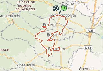
Trail Walking of 17.3 km to be discovered at Grand Est, Haut-Rhin, Saint-Hippolyte. This trail is proposed by VacheKiri67.

Description

Faite le 14/04/2024. Le départ peut aussi se faire de Bergheim.

Elevation profile

Photos

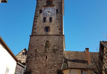
34 photos in total. Please click on a photo to see them all in the gallery.

Positioning

Country:
France
Region :
Grand Est
Department/Province :
Haut-Rhin
Municipality :
Saint-Hippolyte
Location:
Unknown
Start:(UTM)
378682 ; 5343485 (32U) N.

Trails nearby

Trail Walking Châtenois - Le Hahnenberg et les balcons Sélestat - Photo
Walking
VacheKiri67

Walking

Medium
(2)
Châtenois, Grand Est, Bas-Rhin, France
12 km | 17.2 km-effort
4h 29min
Yes
Trail Mountain bike Ribeauvillé - Ribeauvillé Riquewihr - Photo
Mountain bike
tracegps

Mountain bike

Medium
(1)
Ribeauvillé, Grand Est, Haut-Rhin, France
19.3 km | 24 km-effort
1h 30min
Yes
Trail Walking Kintzheim - suuntoapp-Hiking-2023-10-15T07-53-44Z - Photo
Walking
GUIDE
holtzv

Walking

Medium
Kintzheim, Grand Est, Bas-Rhin, France
18.5 km | 28 km-effort
6h 16min
Yes
Trail Walking Saint-Hippolyte - St hippolyte ht koenigsbourg - Photo
Walking
legereric

Walking

Medium
(2)
Saint-Hippolyte, Grand Est, Haut-Rhin, France
12 km | 18.7 km-effort
3h 27min
Yes
Trail Mountain bike Bergheim - 1 ère sortie - Photo
Mountain bike
Jeje Seuil

Mountain bike

Easy
Bergheim, Grand Est, Haut-Rhin, France
12.6 km | 19.1 km-effort
1h 53min
Yes
Trail Walking Rorschwihr - rorschwihr ac3 - Photo
Walking
colsonandre

Walking

Medium
Rorschwihr, Grand Est, Haut-Rhin, France
6.8 km | 9.2 km-effort
3h 54min
Yes
Trail Walking Thannenkirch - Taennchel par Thannenkirch - Photo
Walking
Mich&Agnès

Walking

Medium
(2)
Thannenkirch, Grand Est, Haut-Rhin, France
15.5 km | 23 km-effort
5h 19min
Yes
Trail Walking Ribeauvillé - Ribeauvillé et ses 3 châteaux - Monastère ND de Dusenbach - Photo
Walking
Bart2015

Walking

Difficult
Ribeauvillé, Grand Est, Haut-Rhin, France
12.1 km | 22 km-effort
3h 9min
No
Trail Walking Saint-Hippolyte - St Hippolyte - Bergheim - château Reichenberg - Photo
Walking
Bart2015

Walking

Medium
Saint-Hippolyte, Grand Est, Haut-Rhin, France
12.9 km | 16.5 km-effort
3h 14min
Yes


Close
My subscriptions